
Category Archives: Stormwater
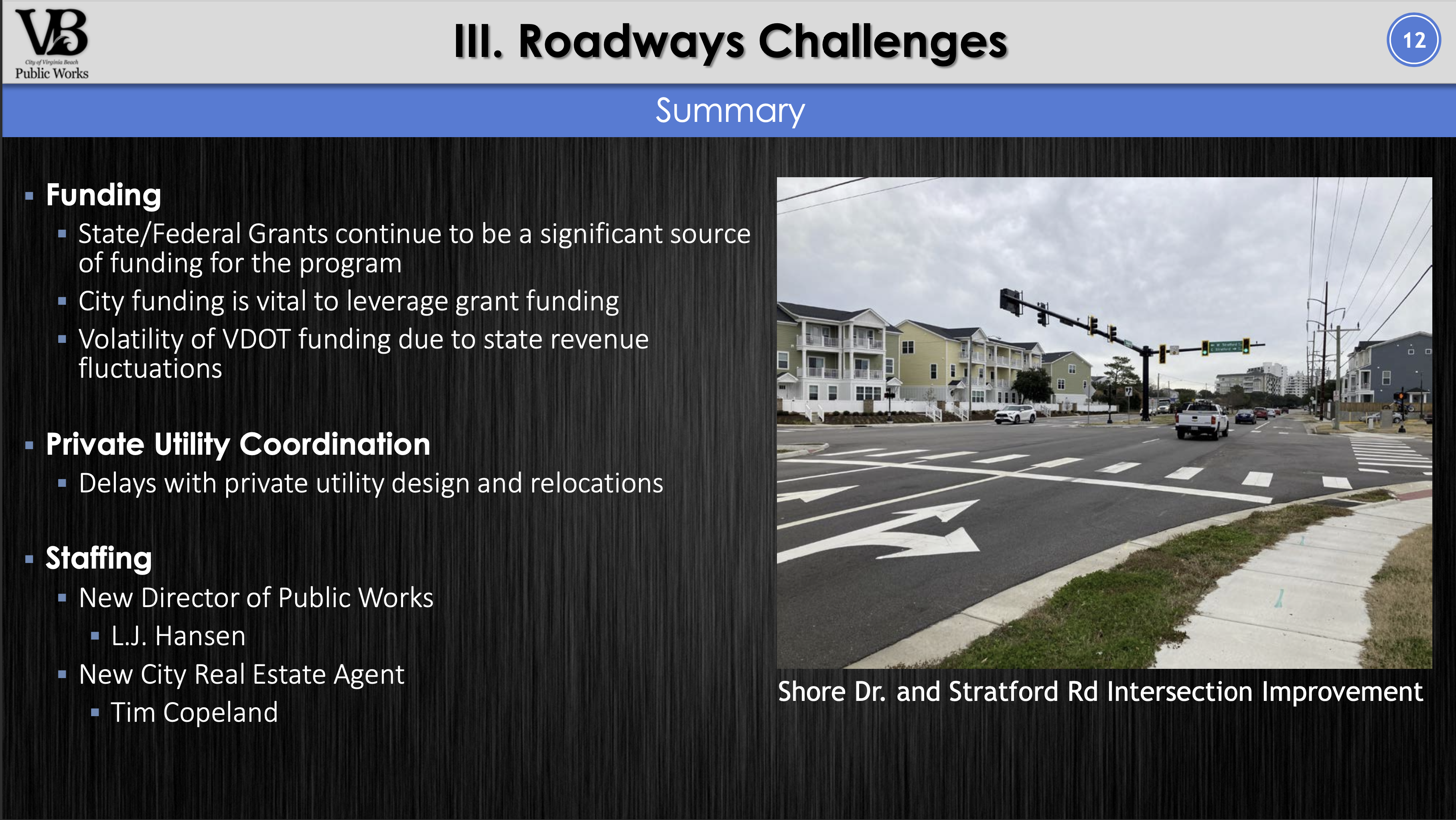
Public Works roadway work update at BAC
Terrific discussion and Q&A at BAC meeting yesterday about storm water work being done from Lesner Bridge to Great Neck Road plus updates on infrastructure improvements to Pleasure House Road and Shore Drive Phase 3 and Phase 4 timelines.

BAYFRONT ADVISORY COMMISSION May 20, 2021 DELTA VIRGINIA BEACH BAYFRONT CONFERENCE CENTER, 2800 SHORE DRIVE
Agenda:
TOUR OF HOTEL – 2:30
CALL TO ORDER OF MEETING – 3:30
APPROVAL OF MINUTES
Review and Approval of Minutes from 4/15/2021
CHAIRMAN’S REPORT
Welcome Guests and Introductions – Phil Davenport, Chair
STAFF REPORTS & UPDATES
Mark Shea and Nina Goodale
COMMITTEE REPORTS & UPDATES
Design – Bob Magoon, Joe Bovee (volunteer)
Communications – Vacant
Public Safety, Transit, Parking & Pedestrian Access – Charles Malbon
PRESENTATIONS
1) Beach Building Group, Inc., 2332 Pleasure House Road, Conditional Change of Zoning from R-7.5 Residential to A-16 Apartment District
2) Bubba’s, 3323 Shore Drive, Conditional Use Permit for marina decking
3) Design by Eleni, Inc., 2416 Seaview Avenue, Change in Conformity
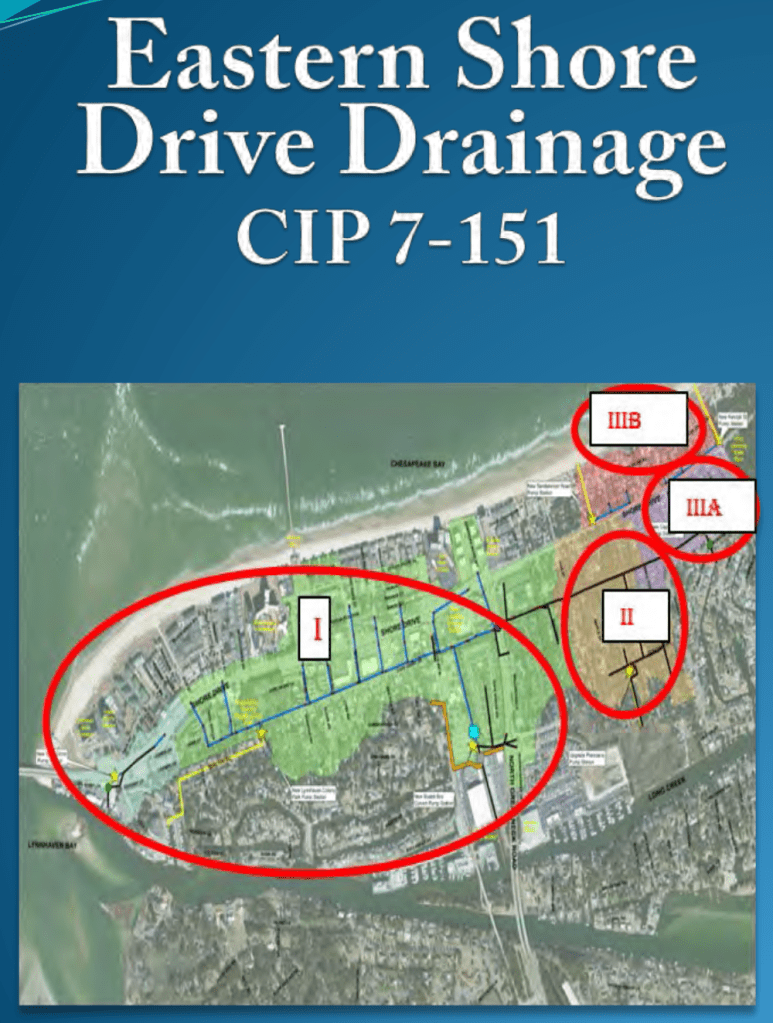
4) Eastern Shore Drive Drainage, Bradley Vanderwarker, Dept. of Public Works
OLD BUSINESS
NEW BUSINESS
COMMUNITY REPORTS & UPDATES
ADJOURN

You have questions about SeeClickFix abrupt switch to VB Works? We don’t have answers.
We’ve been patiently waiting for feedback about the abrupt switch that happened last week. We’ve reached out to several people & added a Request using the Guest feature of VB Works and haven’t heard back yet.
A few of our questions are:
Will SeeClickFix Account be automatically migrated to VB Works?
Will custom maps created in SeeClickFix be automatically migrated to VB Works?
Will current open SeeClickFix issues be automatically migrated to VB Works?
What should SeeClickFix users do and when?
Will your office put out guidance about the switch?
We also have some questions about Privacy as the new company behind VB Works – Incapsulate, which is a subsidiary of Sales Force, asks for what appears to be an enormous amount of information to use VB Works. We could find no info about ThreeOneOneCapsule.

We’ve also asked about the details for each item Sales Force is requesting to use the VB Works app system.
We sincerely hope VB Works becomes as popular as SeeClickFix was!


If you have any feedback about the switch, please let us know!
May 24th 730 OPVRS SDCC Meeting save the date!
We’ll be safely meeting in Ocean Park Volunteer Rescue Squad May 24th at 730pm.
Join us!
Brad Vanderwarker & team from Public Works Stormwater Engineering will be providing an update on what’s happening east of Lesner Bridge.
They’ll be answering your questions too,
Join us! More details to follow.
Curious about Phase 3? It’s start has apparently been pushed back to late 2022 and Phase 4 has also been pushed back several years.
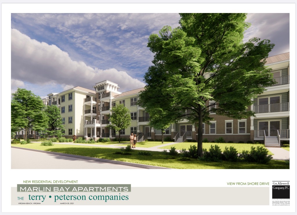
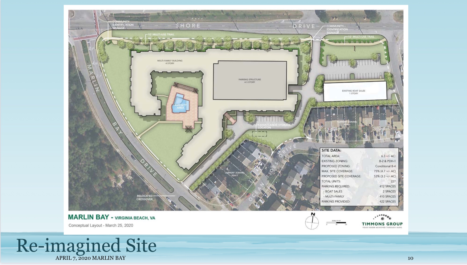
Marlin Bay development reduced from 227 units to 197.
Recently presented at Bayfront Advisory Committee meeting and also available here.
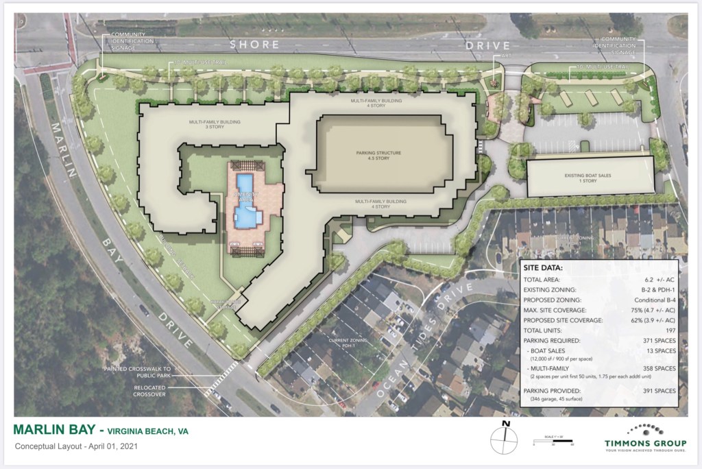
Planning Commission will vote on their recommendation concerning the proposed 197 unit Marlin Bay Apartment Complex on June 9th after the public hearing at the Virginia Beach Convention Center.
The Staff Report will be posted with the recommendation of the City Planning Department by noon on June 3rd.
Contact City Planner Hoa N. Dao, Planner III
- hDao@VBGov.com
- 757.385.4298
SeeClickFix no more. Use new mobile app VB Works.
In the works since August ‘20, view Press Release, VB Works is new system to alert COVB of issues in your neighborhood.
We’ve been curious since last Thursday when apparently the switch from SeeClickFix was made.
Questions we have include if SeeClickFix issues will migrate to new system or if the data is gone. Do SeeClickFix accounts get migrated to new VB Works and if custom maps & automated alerts for certain locations can be customized. We’ll of course let you know when we know.


“More Virginians could receive discounts soon on flood insurance as part of an expansion of a little-known federal program. The Community Rating System, or CRS, reduces peoples’ flood insurance premiums if they live in cities that take steps to mitigate flooding.”
People in less vulnerable areas receive limited discounts. Residents who are not required to have flood insurance but still do are not eligible for any discount.
Starting in October, that will change. The Federal Emergency Management Agency, which oversees the rating system, says all policy holders in a locality will receive the maximum flood insurance discount regardless of their flood risk or type of policy.

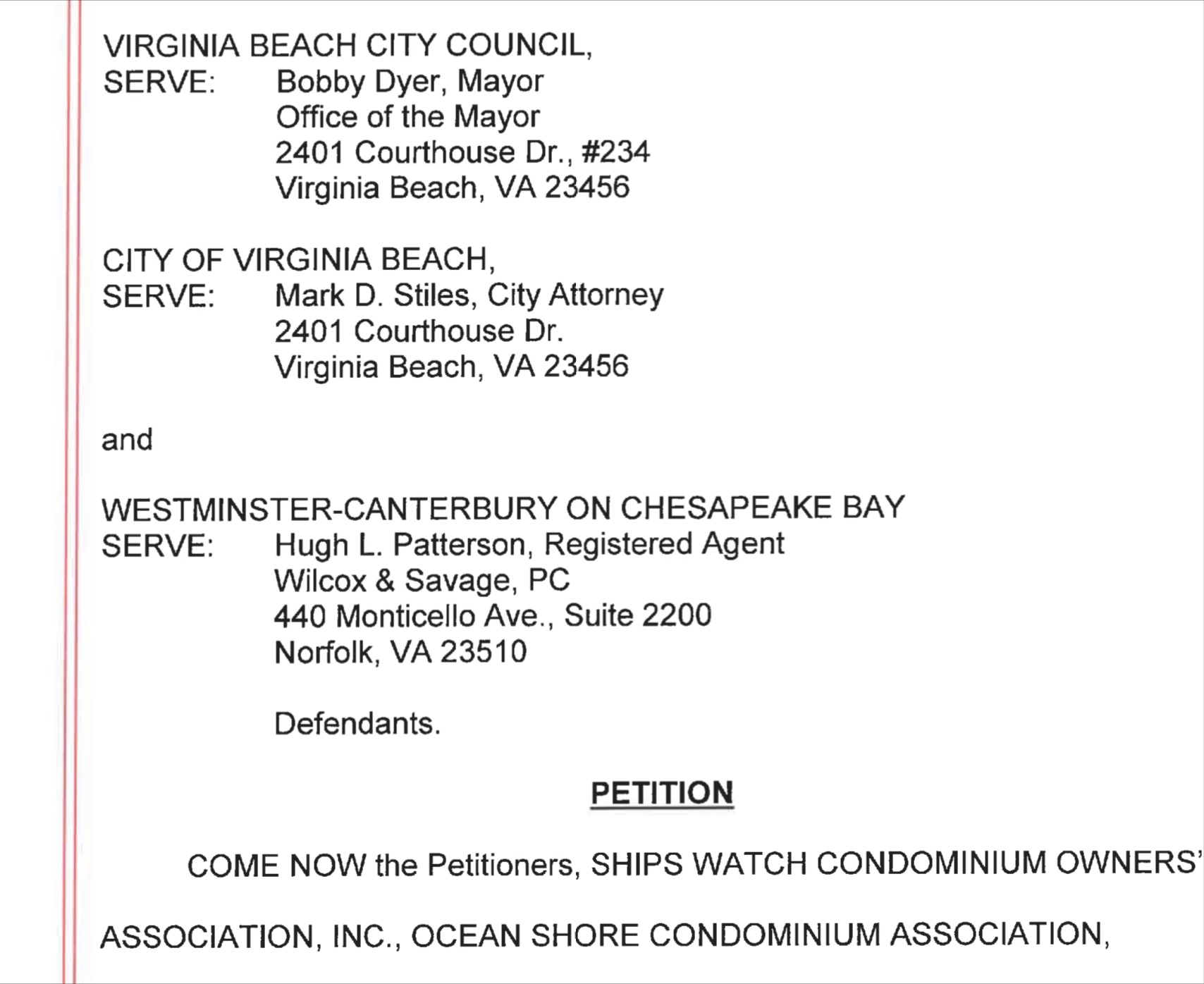
LAWSUIT against VIRGINIA BEACH CITY COUNCIL APRIL 29 2021 re: WCCB
Ocean Shore Condominium Association v. Virginia Beach City Council
Case # CL20006718-00
April 29 Thursday 2:15PM
Virginia Beach Circuit Court
WCCB Category at SDCC.info here.
Commonwealth of Virginia Selects Dewberry to Assist in Developing Coastal Resilience Master Plan
Among its many achievements in the coastal adaptation and protection space, the Dewberry team has played a significant role in developing the Louisiana Coastal Protection and Restoration Master Plans, and was the lead consultant on the City of Virginia Beach’s recently completed Sea Level Wise planning project.
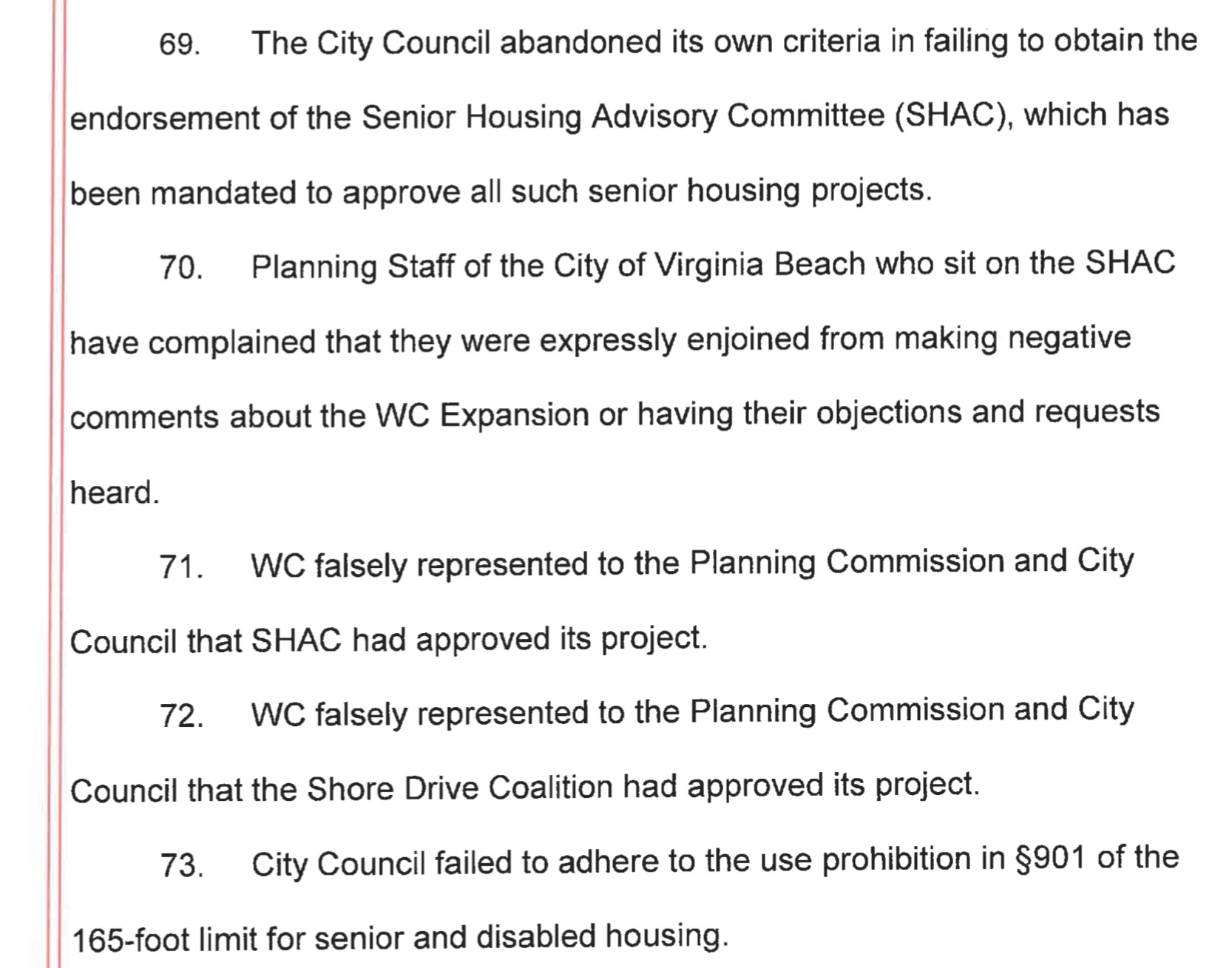
Planning Commission sets another negative precedent expanding use of A-24 & A-36 Zoning in Shore Drive Community
“At the last general membership meeting, the OPCL voted to match Ocean Park residents’ contributions to the Stop Westminster Canterbury legal fund.”
If you would like to make a matched contribution, use the link below and forward your email confirmation to the OPCL Treasurer or board member by Jan 31.
OPCL is matching up to $1,000.
Learn more about The Lawsuit & GoFundMe info here.

$19,505 has been raised so far.
Public Works – Stormwater Engineering has scheduled a virtual open house meeting for the Lake Bradford / Chubb Lake (CIP 7-053) project on Thursday, November 12, 2020 between 6 p.m. and 7:30 p.m.
Email update:
Folks/Bradford-Chubb Project Followers:
The City of Virginia Beach’s Public Works – Stormwater Engineering has scheduled a virtual open house meeting for the Lake Bradford / Chubb Lake (CIP 7-053) project on Thursday, November 12, 2020 between 6 p.m. and 7:30 p.m. For information to join the meeting virtually, please visit the project website: http://www.vbgov.com/LakeBradford.
Due to the Covid-19 public health crisis this meeting will not be held in-person and instead we will utilize a virtual platform to host this meeting and continue providing project updates and introduce the upcoming construction projects.
As most of you know, we held an open house/public meeting in November 2019 to hear from residents in the area regarding their flooding concerns and to assist in developing a program of drainage improvements. We received valuable input and feedback from the community and are looking forward to our continued coordination.
Since we met last November, the City and RK&K have made progress on the drainage study and develop a concept of improvements to help mitigate flooding. This concept requires further analysis and the drainage study is anticipated to be completed by the end of next summer.
This will be an informal open house public meeting and will begin with a 30 minute presentation providing an update on the Lake Bradford/Chubb Lake Drainage Study as well as introduce the upcoming Lake Pleasure House Outfall and Lake Bradford Dredging construction projects. Public Works representatives from the City of Virginia Beach will be available to answer questions via the virtual platform following the presentation.
After the presentation, we request attendees complete an online survey to provide feedback on the presentation as well as any comments or concerns for the upcoming construction projects. A link to this online survey will be provided on the project website. Our previous survey was very successful and provided valuable input on flooding concerns in the area.
Again, we want to thank each and every one of you who have participated in some way: attending the meeting, marking maps, taking the survey, emailing us your thoughts and comments, and all the other ways you have contributed. We feel strongly that this can be a very successful project with your suggestions and feedback.
Please contact us at lakebradford@vbgov.com with your comments and questions. Also, go to our website at http://www.vbgov.com/lakebradford for updated information.
If you have any pictures of flooding, please email them to stormpics@vbgov.com. Please include the location, date, and time the picture was taken.
Again, thank you for your participation in this project and we look forward to continue working with all of you. Please stay safe during this difficult time.
Matthew Richardson, Project Manager
Lake Bradford / Chubb Lake Drainage Study (CIP #7-053).
Public Works – Engineering
757-385 -4131
Multiple Shore Drive Condominium Associations has organized a GoFundMe FUNDRAISER & LAWSUIT vs City of Virginia Beach & WCCB to stop precedent setting high rise in Shore Drive community subjectively approved by 5 City Council members
Westminster Canterbury Expansion-Stop City Council GoFundMe FUNDRAISER link:
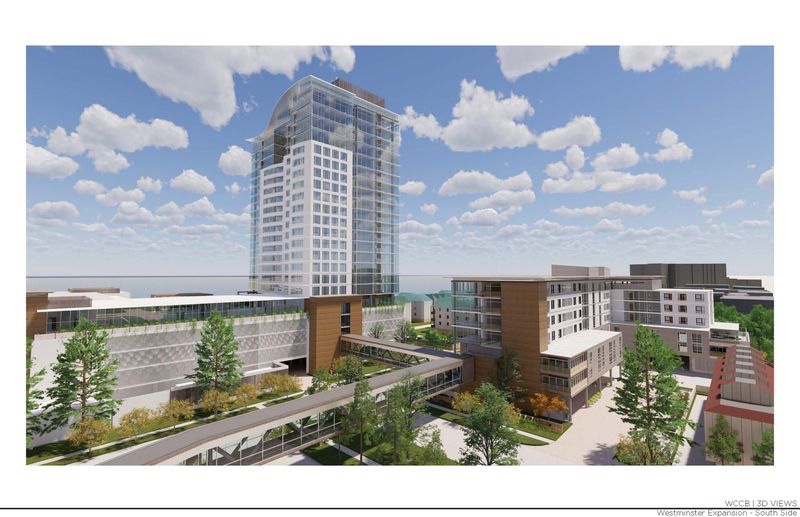
Virginia Beach City Council has approved plans to allow a 22 story building expansion of Westminster Canterbury. This will create a structure rivaling Town Center and potentially supporting other high rise development in the Bayfront neighborhoods along Shore Drive. This precedent setting decision was based solely on the opinions of 5 Council Members and not based on quantifiable City codes or requirements.
VIEW LAWSUIT v. VIRGINIA BEACH CITY COUNCIL, CITY of VIRGINIA BEACH, WESTMINSTER-CANTERBURY on Chesapeake Bay ( 29 page PDF )
Over $11,000 has been raised in just a couple days.
Join us & many others who don’t want to see the Shore Drive community & potentially other areas of Virginia Beach have an explosion of density & high rises due to this arbitrary decision made by 5 people.
Westminster Canterbury Expansion-Stop City Council GoFundMe FUNDRAISER link:
Virginia Beach City Council has approved plans to allow a 22 story building expansion of Westminster Canterbury. This will create a structure rivaling Town Center and potentially supporting other high rise development in the Bayfront neighborhoods along Shore Drive. This precedent setting decision was based solely on the opinions of 5 Council Members and not based on quantifiable City codes or requirements.
“It’s so tiny that it’s going to immediately diffuse into the environment. And plastics last, depending on the plastic, hundreds or thousands of years. That’s why we say it’s effectively permanent”
“It was horrible. It was all bunched into all of the grasses, getting into the water. Just clearly a detriment to the animals around here. So, it was upsetting, to say the least.”
“Subsequent to the Planning Commission Public Hearing The Applicant has provided Staff with a New submittal…” ~ Planning Director July 28 2020
Is it more appropriate to DEFER the Public Hearing scheduled for City Council Meeting August 4th 2020 to allow the City to hold the necessary public forum and reach an acceptable compromise rather than try to work a solution during a Public Hearing that also includes very real health risks for its participants considering:
The unknown recent changes Large opposition to publicly seen proposed development 3 Councilpersons needing to recuse themselves Inconsistencies throughout the entire process to date The complexity of the precedent setting “iconic building” WCCB will have in the Shore Drive Community for decades
Recent FOIA documents available below.
Note: Attachments mentioned in many emails were not included for the public to view.
R-F008829-072120_-_Mayors_Office_Responsive_Documents
Affects of the Westminster-Canterbury Expansion
Re Westminster Canterbury potential expansion
RE Westminster Canterbury Expansion concern
RE Shore Drive Community Coalition Position Statement – Westminster Canterbury Expansion
Westminster Canterbury Expansion concern
Shore Drive Communtiy Coaltion Position Statement – Westminster Canterbury Expansion
“We have 2 presentations coming up now because of the complexity . . .” ~ Mayor Dyer July 28th 2020
It seems everyone understands how complex the proposed development is. What’s the rush to attempt to push it through with incomplete information & lack of public input on an unseen “new submittal”.

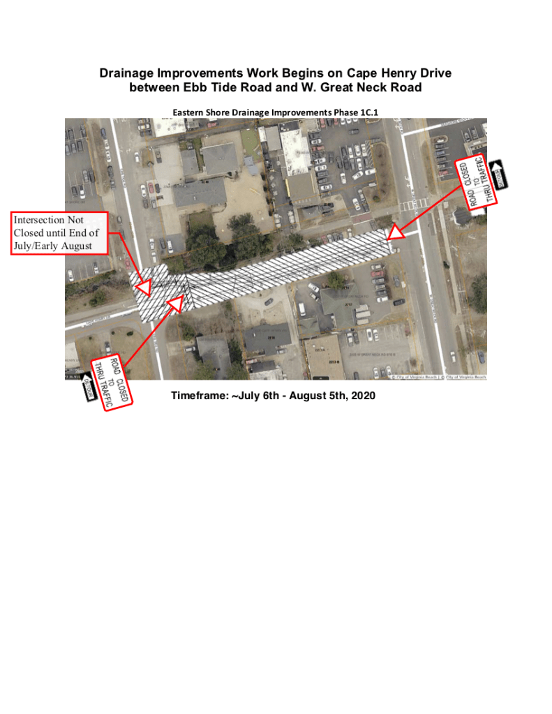
The contractor has finished work at N. Great Neck Road, Starfish Rd, the new culvert pipe behind the Fire Station in the Cape Henry Canal (CHC), and the associated overlay to the CHC Trail, and is approximately 90% complete at Red Tide Road.
Update from email:
Virginia Beach Public Works is providing an update for the Eastern Shore Drive Drainage Improvements Project Phase 1C.1 currently underway.
The contractor has finished work at N. Great Neck Road, Starfish Rd, the new culvert pipe behind the Fire Station in the Cape Henry Canal (CHC), and the associated overlay to the CHC Trail, and is approximately 90% complete at Red Tide Road.
On July 6th 2020, work will progress to Cape Henry Drive between Ebb Tide Road and W. Great Neck Road. This work is the first stage of utility relocations of smaller-scale water and sanitary sewer utilities between these end points. It’s important to note that this work will not interfere with the normal traffic at W. Great Neck Road. The intersection of Ebb Tide Rd/Cape Henry Drive will not be shut-down until the end of this work in late July/early August. Contractor will continue to provide access to driveways and the Citrus delivery area.
The anticipated schedule is:
Complete closure of Cape Henry Drive between Ebb Tide Road and W. Great Neck Road. Contractor will provide access to driveways and the Citrus delivery area.July 6th, 2020 – August 5th, 2020.
The contractor for the job is Tidewater Utility Construction Inc.
For additional information, please contact Shannon Bruce, Project Manager with Tidewater Utility Construction at (757) 944-0795, or Public Works Engineering at (757) 385-4131.
Road Resurfacing Planned for Repair of Work Areas at Starfish Rd, N. Great Neck Rd, Red Tide Rd and the Cape Henry Trail

Hello Shore Drive Community,
The following emails are updates from our friendly neighborhood Project Engineer regarding the repaving of areas that have recently had stormwater improvements completed. It looks like paving of these areas is scheduled to be finished by the end of July.
Stay safe and stay healthy,
Todd
Dear SDCC,
An update for you on the some of the “rough-rides” you may be experiencing at Starfish Rd and N. Great Neck Rd.
Good news for these asphalt issues. We are trying to be fair to the contractor and limit his mobilization of final Asphalt surface course construction to two occurrences. The reason it is riding a little rough is because intermediate course has been placed on top for now, and yes, there are noticeable differences in elevation at the edge points that create a bump. The contractor is working at Red Tide Rd right now, and after he completes the storm sewer construction, we will then be milling (pavement planning) the asphalt down at Starfish Road, North Great Neck Road, the Cape Henry canal Trail and Red Tide Road. Then a complete overlay of surface course asphalt will be placed back in accordance with the Contract Documents.
At N. Great Neck Road, we are going to slightly beyond the limits of the trench excavation to make sure there is “no bump” and mill out the asphalt to only the right turn lane (northbound) and merging lane (southbound). But the future Shore Drive Phase III roadway project in a couple years (100% design) will be providing a complete intersection pavement rebuild along with that project. For Starfish Rd and Red Tide Rd, it will be complete face-of-curb (edge-of-pavement)) to the other face-of-curb (edge-of-pavement).
All This work will be completed by July.
The second mobilization of asphalt surface course will occur after the heavy construction at West Great Neck Road and Cape Henry Drive in the summer and fall.
Best Regards,
Brad
Bradley W. Vanderwarker, P.E.
Project Manager
City of Virginia Beach
PW/Stormwater Eng. Center
2473 N. Landing Road, Building 23, Room 139
Virginia Beach, VA 23456
(757) 385-4131 (main)
(757) 385-8556 (direct)
(757) 705-7507 (cellular)
bvanderwarker@vbgov.com
Additional details of the work being done on the Cape Henry Trail. A plan of the work location can be seen by clicking here Cape Henry Trail Milling & Surface Course Overlay
Todd/Tim,
The milling and resurfacing of the Cape Henry Trail between W. Great Neck Road and N. Great Neck Road is graphically displayed in the attached.
This will provide a nice smooth trail system from the major construction at W. Great Neck Road over and through where the large 76”x48” Culvert behind the Fire Station was recently constructed. It ends just west of Sunstate Ct. where shown. It was not in the scope of this project to repair and resurface the trail to the east over to Beech Street.
Even with the localized construction at N. Great Neck Road, we are only repairing a localized section of the stamped brick area on the west side of N. Great Neck Road.
Further questions relative to the Cape Henry Trail program may be directed to Elaine Linn elinn@vbgov.com with Parks & Rec.
“I’m not for it and I’m not against it. I’m for working with the developers and the city and other stakeholders because the developers own property on Pleasure House Point that’s not preserved yet, so I think the smart thing would be to work with them,” he said.
There’s a plan to build more than 200 apartments on Shore Drive. The planned development would be located where an old boat and RV storage yard currently sits at the intersection of Marlin Bay and Shore Drive.
While people said there is a need for more housing in the area, some neighbors are pushing back on the plans.

Note the amount of trees and vital habitat that is at risk for destruction. Birds, including those migrating in the Atlantic Flyway, depend on Pleasure House Point and it’s open space to survive.
Lake Bradford – Chubb Lake Stormwater Improvement Projects – City Update #1

The following is the first City update for the Lake Bradford-Chubb Lake Stormwater Improvement Project. Lots of good information, sign up with the City for direct email if you are interested in following this topic. SDCC will also post future updates on our website, so you can keep informed that way as well.
Click here to see the survey results document. Lake Bradford – Chubb Lake – Survey Results – January 2020
Folks/Bradford-Chubb Project Followers:
For those of you who are somewhat new to following Public Works projects, you will find that we at VBPW believe very strongly in keeping the public informed and allowing 2-way communications. That means keeping you informed of how our projects are progressing, letting you know when we hit a snag or there is a change in plans, and whenever there will be traffic delays or traffic pattern changes. It’s robust work, but someone has to do it . . . and I volunteered because my boss told me to.
I can’t stress enough our belief in this concept, particularly in terms of hearing from you. We’ve learned from experience that the better-informed we keep you, the less chance there is of misinformation being passed around or needless anxiety. That’s why we have set up this specific email address for your questions and concerns. As Mr. Richardson, stormwater engineering savant and project manager for this explains below – you can contact us through this email address, you can go to our web page, or you can contact me. One way or another, we will get you an answer and the information you seek.
You’ll find as we continue to send out these updates that we try and keep it light as well as informative. We want you to have the information you need and the answers you seek . . . otherwise I have a lot of explaining to do to my boss.
As you can see, the email address to use is: lakebradford@vbgov.com. The esteemed Mr. Richardson has attached additional information in his section. Once we establish some social media contacts, I will pass them along to you as well.
Lastly . . . . as in this is the last thing I will mention – if you know of someone who should be included in these updates, or WANTS to be included, please pass this along to them, or send me their information and I will add them to the list.
We hope to set these up on a regular basis and I will let you know as we go along. I hope you will find the information helpful, and don’t hesitate to contact us if needed.
Enjoy what looks to be a great weekend weather wise and if possible, don’t cough on each other.
Stay safe!
Drew Lankford
Media and Communications
Department of Public Works
City of Virginia Beach
dlankfor@vbgov.com
(O) 757.385.8062
(C) 757.409.4353
*********************************************************************************************************************
Folks:
As most of you know, Public Works – Stormwater Engineering held an open house/public meeting at the Bayside Recreation Center last November.
We organized the meeting because we wanted to hear from the residents as to what their concerns were and to get their help in identifying flooding locations in their neighborhood.
The meeting began with a presentation that provided some background and history of the Lake Bradford/Chubb Lake Drainage Study, along with reasons for the flooding and potential types of solutions.
After the presentation, attendees were directed to visit five stations that were set up around the room to gather different information. Of particular interest to the engineers was the station, “Flooding Locations/Surveys.” At this station, we encouraged everyone to mark areas of concern or known flooding on a map. They were also given a comment card to describe those concerns and the impact from the flooding in greater detail.
Prior to the meeting, we had developed an online survey for the public to take. We produced post cards with the survey link on the card to send to anyone who could not attend the meeting. That information was also given to the attendees, as well as the project’s web address – project’s webpage – where a link to the survey was available. Hard copies of the survey were also available at the meeting for those who preferred that method of input.
Much to our surprise – AND pleasure – we had over 100 people who participated in the survey. Thank you one and all who did – your input was very valuable in helping us understand your concerns about flooding and the impact on you. That kind of information is invaluable when developing our plans.
With the flooding locations map and the survey results, we were able to identify the problem areas and places of concern within the project area.
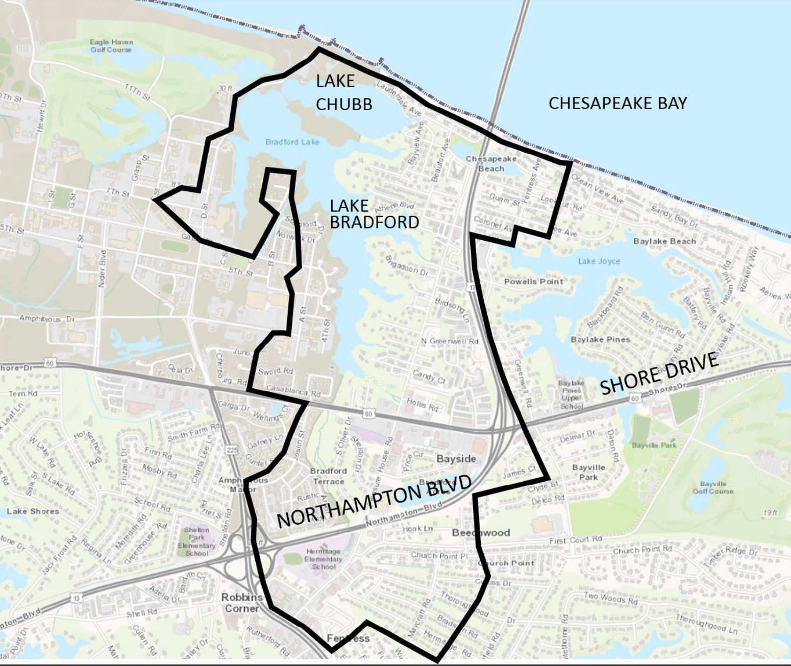
They included areas with known flooding problems in the neighborhoods of:
Bayville Gardens
Chesapeake Beach
Chubb Lake Terrace
Church Point
Thoroughgood neighborhoods
Some of the roads identified as areas of concern or flooding during the survey include:
Beaufort Avenue
Brigadoon Drive
Chubb Lake Avenue
Hermitage Road
Independence Boulevard (near the entrance to JEB LC)
Lauderdale Avenue
Lee Court
Lookout Road
Maycraft Road
Northampton Boulevard
Pleasure House Road
Shore Drive
Not surprisingly, these areas and roads align almost perfectly with the areas we had identified in our stormwater model.
The results from the survey and the flooding locations map are attached, and a copy of the map is at the bottom of this email. You can also find a Summary of the Public Survey and Comments on our project’s webpage.
Since we met in November, the City and RK&K have continued to analyze the project area and develop a recommendation to help mitigate flooding. The analysis includes:
Analyzing stormwater pipes and ditch capacities
Rainfall and tide joint probabilities
Sea level rise
One of our tasks now is to analyze each area within the project area with each of these possible scenarios.
As we all know, the public health crisis due to Covid-19 has scrambled all schedules, but IF things can work out, we hope to have another public meeting sometime this fall. If it doesn’t work out that we can meet as a group, we will look into some electronic options that may be possible.
Again, we want to thank each and every one of you who have participated in some way: attending the meeting, marking maps, taking the survey, emailing us your thoughts and comments, and all the other ways you have contributed. We feel strongly that this can be a very successful project with your suggestions and feedback.
Please contact us at lakebradford@vbgov.com with your comments and questions. Also, go to our website at http://www.vbgov.com/lakebradford for updated information.
If you have any pictures of flooding, please email them to stormpics@vbgov.com. Please include the location, date, and time the picture was taken.
Again, thank you for your participation in this project and we look forward to continue working with all of you. Please stay safe during this difficult time.
Matthew Richardson, Project Manager
Lake Bradford / Chubb Lake Drainage Study (CIP #7-053).
Public Works – Engineering
757-385 -4131
