The following update was provided by the City’s Public Works Department. The spreadsheet identifies all of the current projects in the Bayfront Area. Updates are identified in RED.
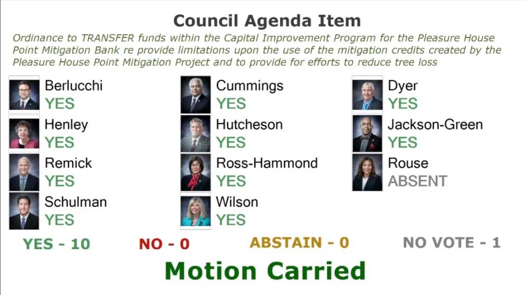
In Tree City USA, the PHP WMB plantings are complete including the 703 saplings listed in contract as $30,520. Less than the tree mulch cost of $34,240.
About WCCB “[m]entioned in [Thursday’s BAC] meeting that the City will not be accepting the beach access ramp from the private developer until it is made ADA compliant. Once the ramp is ADA compliant, the City will accept the ramp and take over maintenance.”
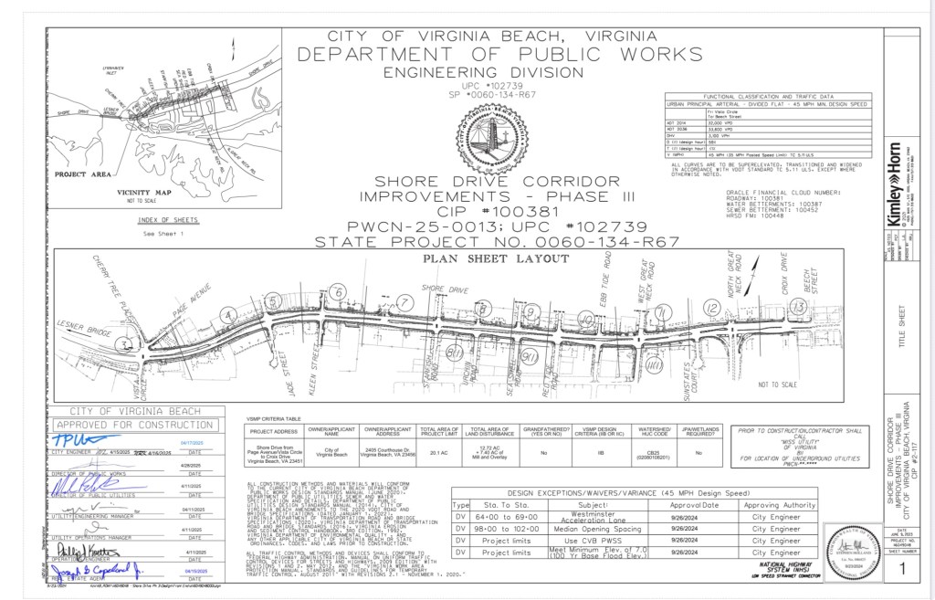
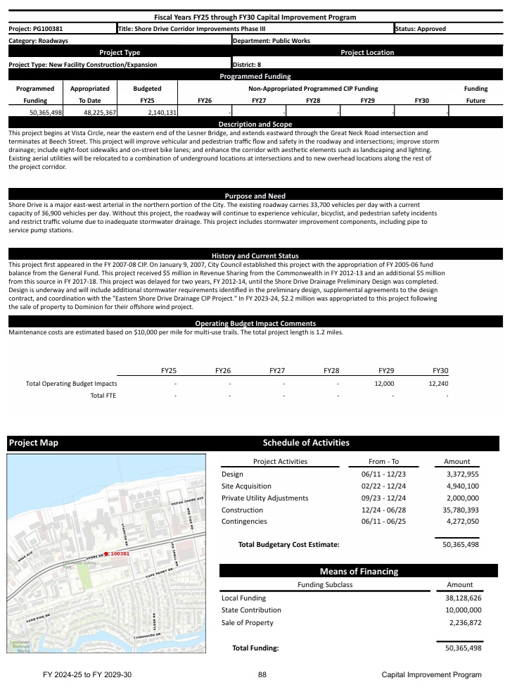
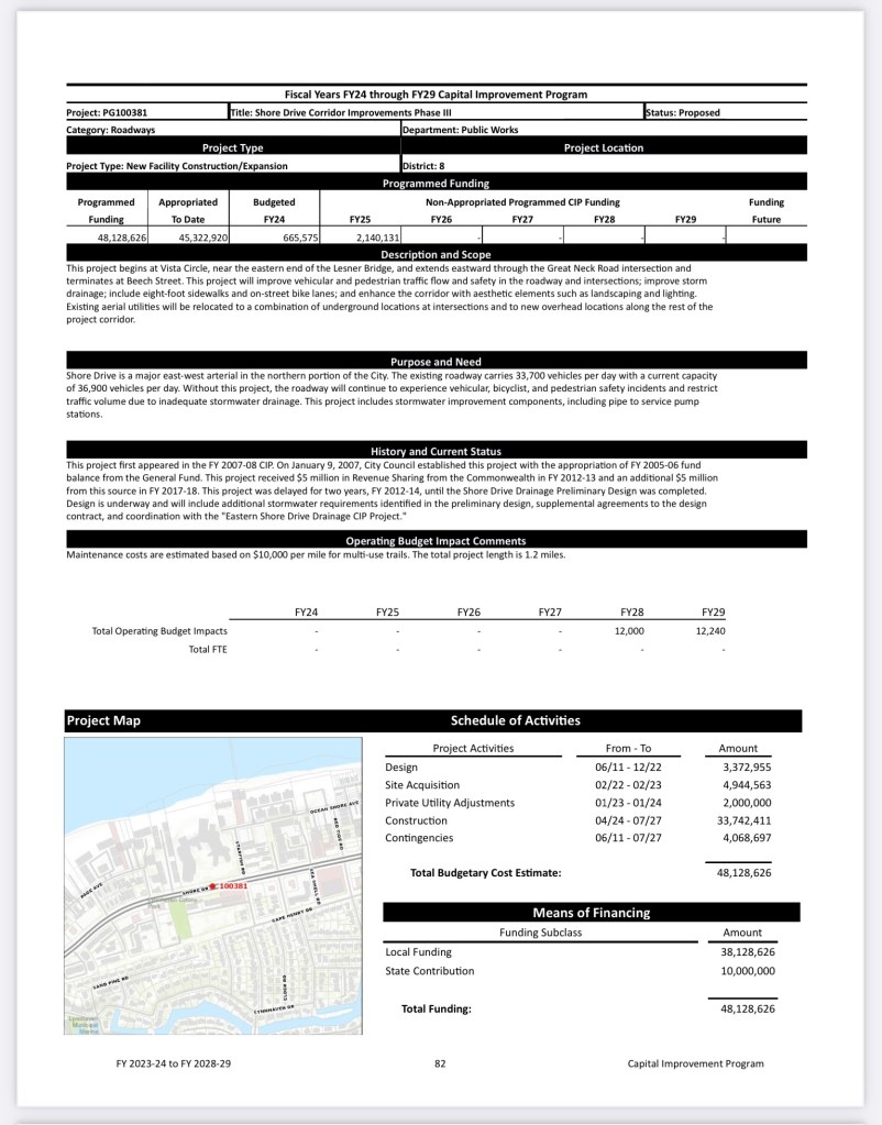
The Shore Drive Phase 3 Improvement Project(SDP3), first identified as a City Capital Improvement Project (CIP) in 2007, is finally getting ready to happen. This 3 year long construction project will improve the section of Shore Drive between the Lesner Bridge and North Great Neck Road, making the road safer for pedestrians and vehicles. Construction will take place over the next 3 years and will definitely have an impact on our Bayfront area in the process.
In an effort to help provide as much information to the residents as possible, we have been working with the City and Councilman Cummings to gather as many details as possible to help answer questions regarding this project. Thanks to the City’s Public Works and Councilman Cummings, we are able to provide the following detailed drawings for construction, traffic management and storm water plans. Please see below for a link to our project page for the SDP3 project.
We understand that this data is a lot to digest and we plan to help by posting drawing analysis reviews and City provided updates as best possible. Similar to the Lesner Bridge 3 year project, we can make it through the pain to get to the well deserved benefits and information will be a critical factor.
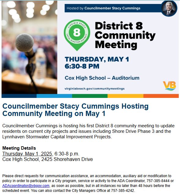
On Thursday May 1st, there will also be an opportunity to learn more about the upcoming construction project at the District 8 Councilman Cummings Community Meeting. More information on this meeting can be found below.
The duties of the Stormwater Management Implementation Advisory Group shall be to:
Further review the topic of stormwater management and its impact and consequences on land use and redevelopment issues.
Identify whether there are any opportunities, advantages, or disadvantages to strengthening regulation alignment and specificity based on the City’s varied drainage basins, and a property’s land use and zoning characteristics.
Formalize a cost-sharing program relative to stormwater infrastructure and policy to include developing criteria for cost-sharing eligibility.
Determine whether there are any opportunities to …
SUBJECT: City of Virginia Beach Public Works VMRC #2024-2851 The application for permit, referenced above, will be heard by the Marine Resources Commission at their public hearing scheduled for Tuesday, February 25, 2025, beginning at 9:30 a.m., at 380 Fenwick Road, Building 96, Fort Monroe, Virginia.
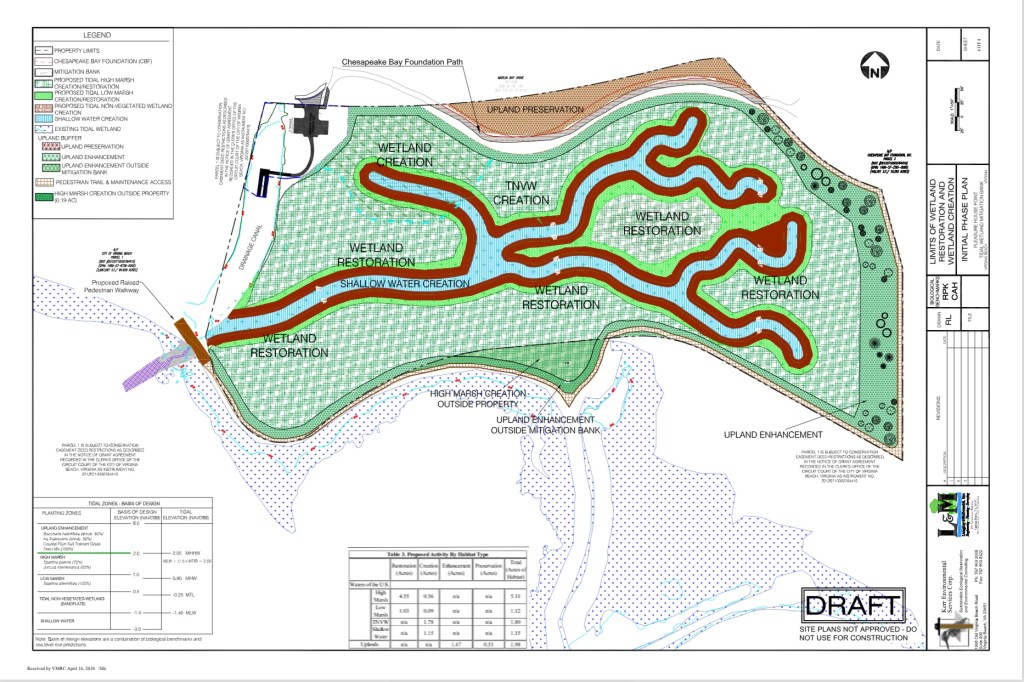
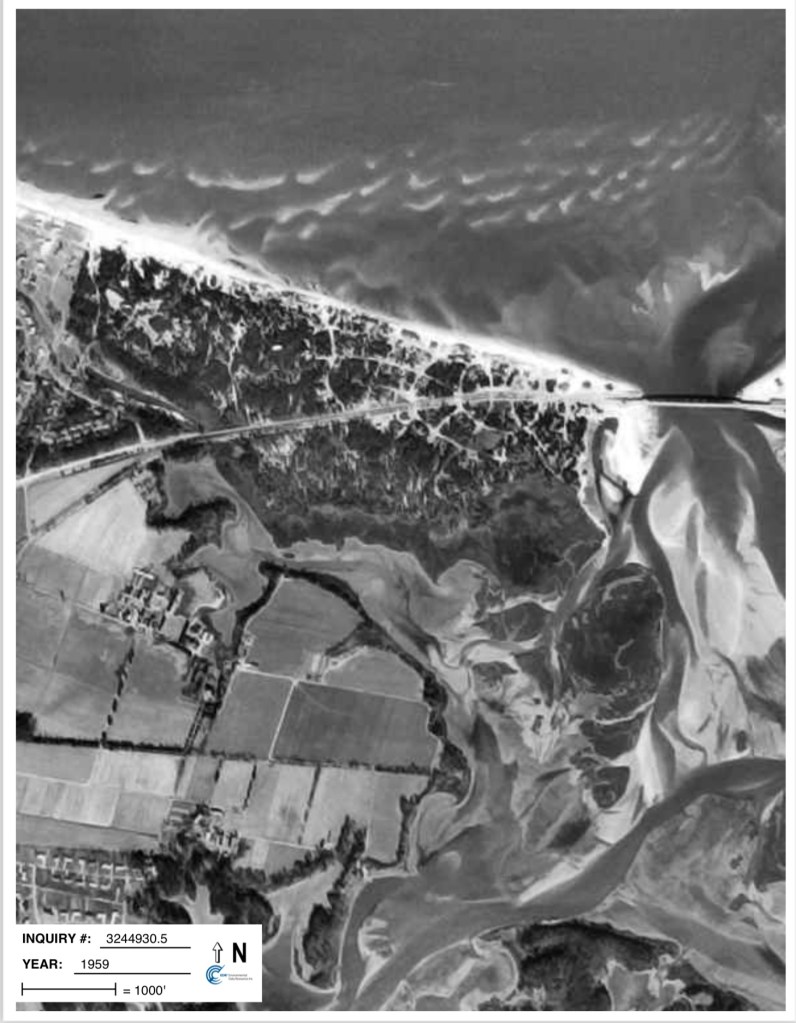
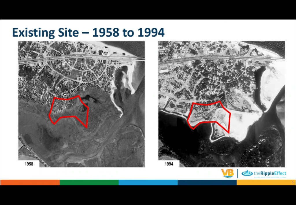
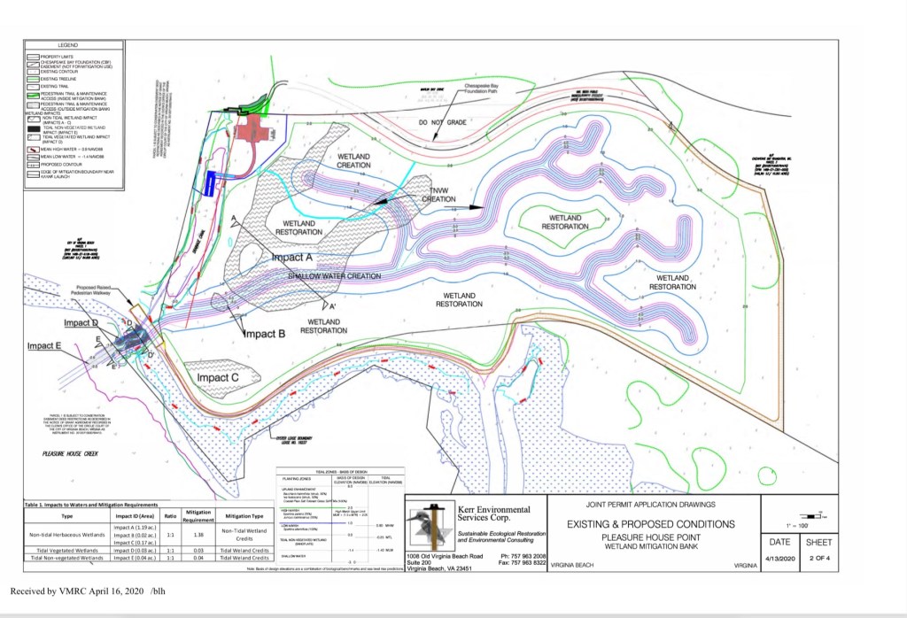
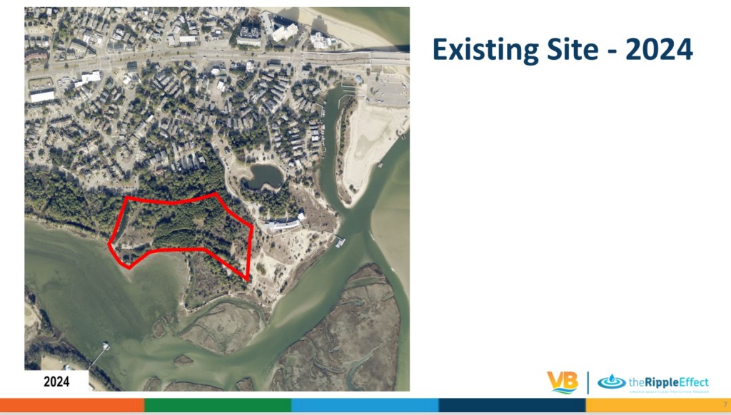
CITY OF VIRGINIA BEACH, #24-2851 requests authorization to mechanically dredge a 20-foot wide by 63-foot long subtidal area to a maximum depth of minus two (-2) feet mean low water within Pleasure House Creek to create a shallow water channel necessary to provide the hydrological connection to the proposed municipal Pleasure House Point Mitigation Bank in Virginia Beach. This project is protested by nearby property owners.
We apologize for the delay sharing these. We were offered them weeks ago and finally received them, from a FOIA request we chose to make, this afternoon.
They are also available on paper in Brock Environmental Center 3663 Marlin Bay Drive.
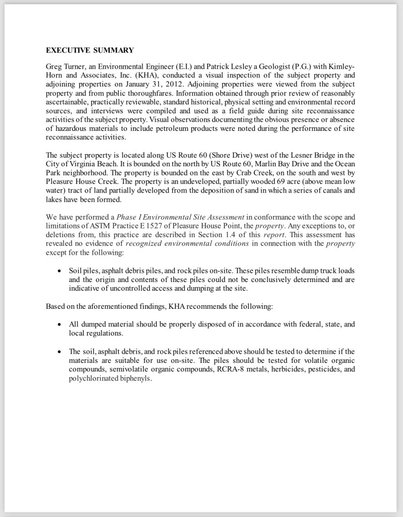
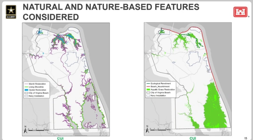
We believe the “purpose & need” of this fast moving project could be violating the spirit of “avoid, minimize, mitigate” in general. Therefore, we humbly request a Phase 1 Environmental Site Assessment and a Phase 2 Environmental Site Assessment are completed before approving the Nationwide 27 Permit.
“Please provide the list of projects that have required the city to buy wetland mitigation credits since the bond referendum passed November 2, 2021 and how many wetland mitigation credits are required now for future projects.” From 11/21/2021 to To 12/23/2024. Your request was forwarded to Public Works. I have been advised that they do not have a list in response to your request. Source: FOIA Request response January 13 2025
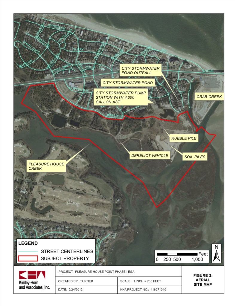
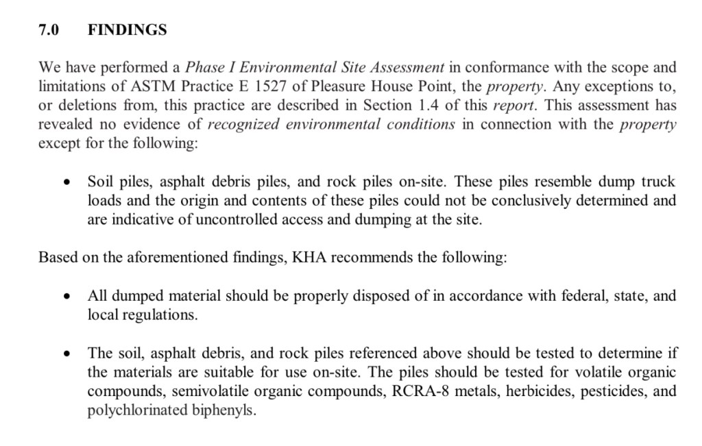
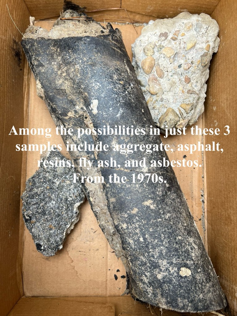
Three(3) samples of material was presented at City Council public hearing which was acknowledged by the Public Works Director – a piece of pavement, concrete with gravel & an unknown petrochemical material all presumably dumped on the spoils site – Pleasure House Point in the area Wetlands Mitigation Bank is proposed – in the 1970s. Was material being tested before dumped? After it was dumped? Video of City Council public hearing January 7th 2025 is provided here: https://www.youtube.com/watch?v=5D_T1v0rI3A
As you know, the Brock Environmental Center and Macon & Joan Brock Classroom campus is literally feet away from this project. Pre-schoolers thru senior citizens routinely spend time there. Meetings with visitors from national & international governments & NGOs also are held routinely. However, this project rolls out. It’ll certainly garner national news. Over 140,000 people have visited the campus since it opened.
In property acquisitions, it is customary for due diligence investigation(s) to be completed before a fee simple property transfer is finalized. It seems reasonable that such an investigation would have reported the obvious; materials of generally unknown origin were dumped on the PHP property as far back as the 1970’s.
These findings would have been followed up with Phase II soil and/or groundwater sampling and testing to screen for regulated substances (hazardous and petroleum constituents). If the investigations were completed, they should be made available to evaluate the potential effects on the proposed PHPWMB project.
Of principal concern is the transport of these dredge materials to the City’s Oceana disposal site, especially if they remain untested. Once removed from PHP, the material becomes a waste, and is subject to VDEQ regulations for transport and disposal. Secondly, possible exposures to regulated substances may result when construction workers are exposed to any contaminated soil, dust, and groundwater. Especially with workers involved in the planting process where hand work is proposed, and the incidence of physical contact with regulated materials may result.
Additionally, considerations for the sampling, testing and handling of regulated materials should be included in the project plans and specifications for the PHPWMB project. This information should be made available for public review and comment.
Therefore, we humbly request a Phase 1 Environmental Site Assessment and a Phase 2 Environmental Site Assessment are completed before approving the Nationwide 27 Permit.
What will be the “reasonably foreseeable effect” if the environmental site assessments haven’t successfully been completed for a spoils site used in the 1970s?
Please note: at the time of this post, currently proposed wetland mitigation bank details of the “90% design”, water budget and other info are still not available on official website.
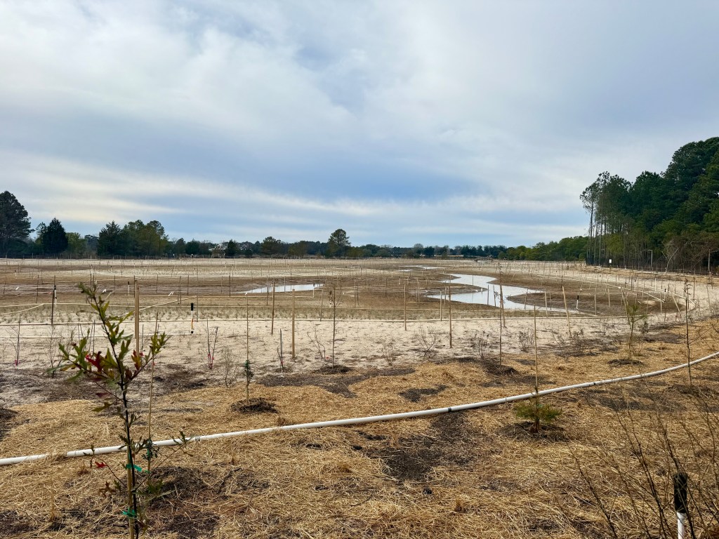
Things learned last night: tidal wetland bank credits are available to purchase, 60,000 cubic yards (about 6,000 dump trucks) of fill will be removed, over 5,200 trees including live oaks over dozens & dozens of years old will be destroyed (number of dump trucks to move destroyed trees unknown).
Email your questions or concerns to: phpwetlands@vbgov.com
Note: this project does not include the controversial kayak launch which will potentially be located on western border of this project when built. It’s visible in graphics above.
Previously, several related links on this website here, here and here.
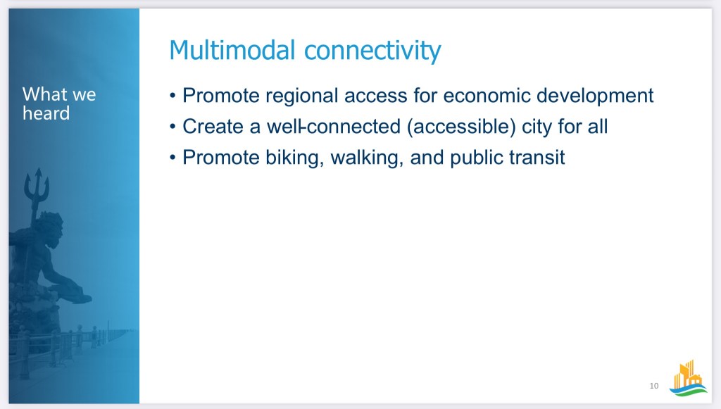
The Public Workshops will consist of a short recap presentation on themes developed in the Focus Groups and the Vision Mapping process. We will then proceed to break out into small groups to provide more direct, specific feedback on each of the draft themes. The Vision Map will take the draft themes of balanced growth, sustainability, connectivity, diversity, and wellbeing, and apply them to areas of the city to create a framework of how the city should grow and develop over time. There will be an interactive planning exercise in our small groups.
The workshops will be held at these times and locations:
Saturday, November 4th at 2pm: College Park Elementary School Cafeteria – 1110 Bennington Road
Monday, November 6th at 6pm: Kellam High School Cafeteria – 2665 West Neck Road
Wednesday, November 8th at 6pm: Bayside Recreation Center – 4500 First Court Road
Thursday, November 9th at 6pm: Virginia Beach Convention Center, Suite 3 (2nd Floor; Middle of the Building) – 1009 19th Street
There is no need to RSVP to these workshops. We estimate this meeting to run about 1.5 to 2 hours. Please pass along the information to your friends, family, neighborhoods, colleagues, youth groups, civic leagues, faith groups, etc.
The more engagement we have from the community in this process, the better the plan will be! City Staff and the Consultant Team are eager to hear from as many residents as possible, so we hope to see you there!
As always, for more information or if you have any outstanding questions, please reach out to me at RacMiller@vbgov.com or Hank Morrison, the Comprehensive Planning Administrator, at JMorrison@vbgov.com.
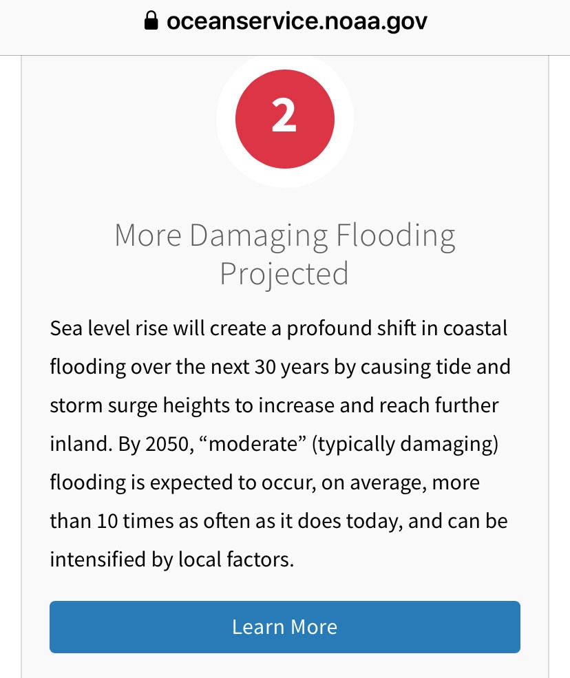
You are aware about the reality of sea level rise(SLR) correct?
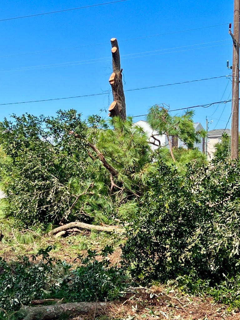
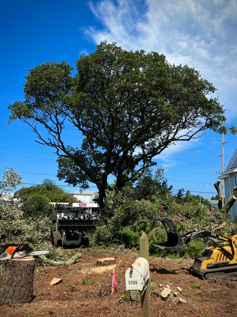
Mistakes were made! This is how many mistakes were made.This was VIOLATED Thursday night and Friday.
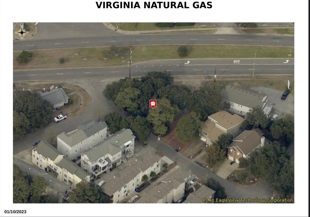
Coincidentally, the VNG Director of Government Affairs made a Presentation Tuesday. Councilman Schulman asked her about the needless destruction, lack of respect by VNG and how to move forward having discussions how VNG, a PUBLIC utility is going to fix this.
Thanks to Mickey Toll, owner of Chesapeake Tree Service, for explaining that the larger live oak pieces being cut down will be hauled away by North Landing Firewood & Hauling Inc and milled for USE AS LUMBER for furniture & other potential uses well beyond mulch & firewood. Hooray!
“By 2050, “moderate” (typically damaging) flooding is expected to occur, on average, more than 10 times as often as it does today, and can be intensified by local factors.”
10X MORE “MODERATE” (TYPICALLY DAMAGING) FLOODING.
Shore Drive is a major east-west arterial in the northern portion of the City. The existing roadway carries 38,800 vehicles per day with a current capacity of 36,900 vehicles per day. Without this project, the roadway will continue to experience vehicular, bicyclist, and pedestrian safety incidents, and restrict traffic volume due to inadequate stormwater drainage.
Welcome to “The Gateway to Virginia Beach” until years & years & years past 2029 according to current City priorities.
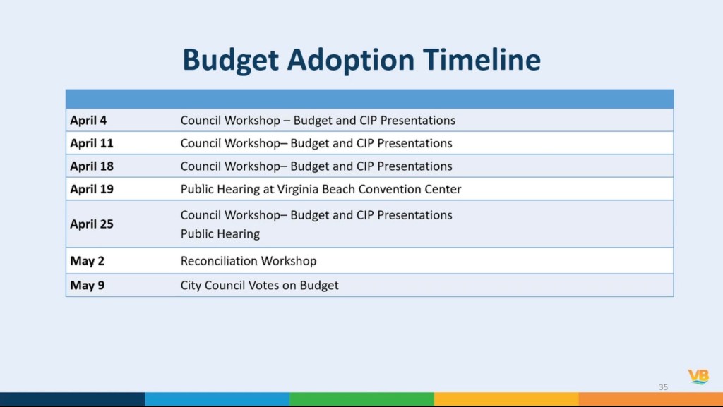
City Manager Proposed Budget Presentation FACE TO FACE PUBLIC ENGAGEMENT OPPORTUNITIES
A few highlights of Proposed City Budget include:
Economic & Tourism Development
EV-22-0001 $200,000 Shore Drive Study Update This project provides an update to the Shore Drive Corridor Plan (2000) and the Shore Drive Corridor Design Guidelines (2002). Flood mitigation strategies from the Joint Land Use Study (JLUS) for JEB Little Creek and JEB Fort Story (2019) as well as the bond referendum projects will be integrated into the update creating a broader, more comprehensive Shore Drive Plan. The Bayfront Advisory Commission will be utilized as a steering committee for the development of the update, public input, coordination, and engagement with the local community. The updated plan/guidelines will include: determination of existing conditions; development of a community wide public input survey; identification of issues and opportunities; development of specific land use recommendations by corridor segment; and development of architectural/landscaping/signage/public infrastructure guidelines.
To bury the other lede:
By the way, with this current proposal YOUR real estate taxes will probably jump over 10% based on recent new assessments.