Ended peacefully.
AERIES IS REOPENED NOW
Ended peacefully.
Ended peacefully.
SWAT, ambulances…. on scene happening now.

Kenneth Robert Allen (1961 – 2014)
View more of Mr. Allen’s obituary.
In lieu of flowers, memorial donations may be made to the Sandbridge Volunteer Rescue Squad.
Mr. Allen was the pedestrian struck on Shore Drive Christmas Eve.
The class will meet every Tuesday for 16 weeks beginning Jan. 13 at Newtown Elementary School, 5277 Learning Circle, from 5:30 to 8 p.m. The class is free and includes dinner and activities to promote healthy family relationships. If interested, please contact Sabrina Pugh at (757) 385-0827 or spugh@vbgov.com . Open enrollment ends Jan. 27.
We are so very sorry for this tragic event.
Our sincere condolences to all those involved, particularly to Mr. Allen’s family and also to the driver of the vehicle and their family.
Obviously there is more we can do to make Shore Drive safer.
We’re fortunate we can share the Adaptive Planning for Flooding and Coastal Change in Virginia: Next Steps for the Commonwealth conference that was held very recently.
Click graphic to visit W&M’s Law School website for conference
To view conference, visit link at William & Mary’s Law School website which includes:
Introductory Remarks & Reports to Commission (1:22:28)
Second session of the Commission (25:11)
Senator Kaine’s Keynote Address (57:24)
FEMA, National Flood Insurance Program’s Community Rating System, and Local Government Liability Panel (1:01:13)
Adaptation: Market Sector Responses Panel (57:11)
Social Vulnerability Panel & Voices of Adaptation in Virginia Panel (1:39:20)
Conference Presentations:
Jim Redick, Secure Commonwealth Panel Presentation
Carl Hershner, Climate Commission Report Presentation
Bill Lesser, NFIP Presentation
Shannon Hulst Jarbeau, CRS Presentation
Kristen Clark, Stormwater CRS Presentation
James Andris, Local Government Liability Presentation
Scott Hunter, Comparity Insurance Presentation
Mike Vernon, Flood Mitigation Hampton Roads Presentation
Lisa Schiavinato, Strict Scrutiny Presentation
Erica Holloman, Southeast CARE Coalition Presentation
Sarah Stafford, Social Vulnerability in Mapping
Molly Mitchell, Virginia Vulnerability Mapping Presentation
Curt Smith, Adaptation on the Eastern Shore of Virginia
Last year, the Virginia Coastal Policy Clinic (VCPC) at the William & Mary Law School and the Center for Coastal Resources Management (CCRM) at the Virginia Institute of Marine Science (VIMS) hosted a forum for state and local government officials as well as coastal stakeholders to discuss the legal and policy challenges presented by coastal flooding.
Described as a “game-changer” for Virginia, the event generated recognition that the magnitude and complexity of these challenges places local governments in a position of needing a variety of assistance if they are to meet their responsibilities to protect health, safety, and welfare.
View Press Release at VirginiaDOT.org here.
To stay informed of lane closures and alternate routes prior to traveling in a work zone
area, motorists can visit 511virginia.org, virginiaroads.org, RepaveHR.com, call 511, download Virginia’s free 511 mobile app, listen to Highway Advisory Radio (HAR) 1680 AM or call the Traffic Information Line at 757-361-3016 for the most current traffic and travel information. Follow us on Twitter, @VaDOTHR.
It only seemed fitting with 12 days until Christmas and the recent Lesner Bridge update (minus the speed bump fix)…..
The state is warning business owners about a private firm sending solicitations that look similar to annual forms required by the State Corporation Commission.
The mailings, from an entity called the Virginia Council for Corporations, ask business owners to return a form, along with a check for $125.
To read the entire Virginian-Pilot article, please click here
There is no reason to use this service and the State is not accepting the documents. Please do not pay them for anything.
Woo hoo!
The purpose of the Complete Streets Policy is to improve the Virginia Beach transportation system by providing safe, attractive travel for all users through a system of connected transportation choices designed in harmony with adjacent land uses.
View Press Release at VBGov.com.
Learn more about Complete Streets Policy at VBGov.com.

View article at Pilotonline.com.
The release states that a property owner agrees the portion of the land between the dune or the bulkhead line and the water is a public beach. The owner gives the city permission to dump sand on it and agrees not to impede public access.
City officials met with Chic’s Beach residents about the project and the release form last month. They’ll need consent from the owners of roughly 140 properties stretching about a mile from Joint Expeditionary Base Little Creek to Joyce Avenue.
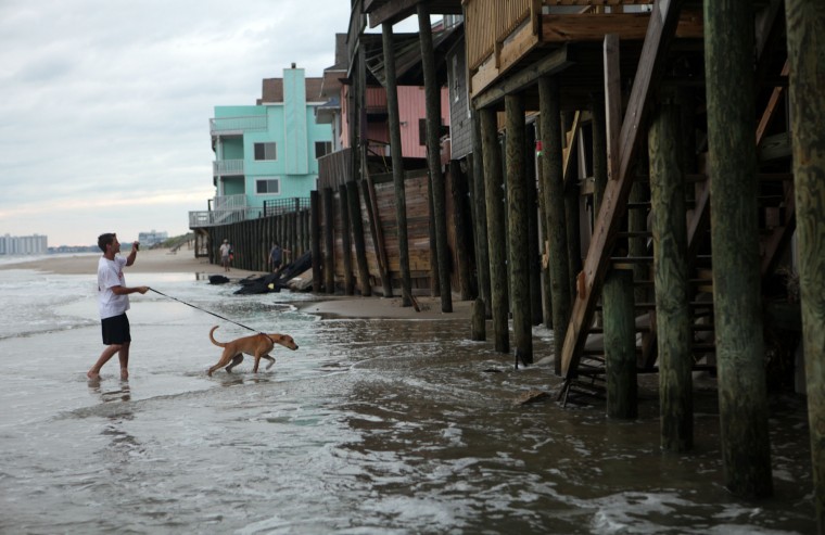
Chic’s Beach resident Taylor Sharpe and his dog Sandy walk the beach there at high tide on Aug. 28, 2011, after the departure of Hurricane Irene. Waves from the Chesapeake Bay lap at the pilings of the waterfront homes on Ocean View Avenue in this section of Virginia Beach. (Vicki Cronis-Nohe | The Virginian-Pilot)
Learn more at VA Coastal Policy Clinic at W&M Law School event page.
[Note: Thank you for the many emails pointing out we had the incorrect date initially. You passed the test.]
The 2009 Comprehensive plan and details can be found on the City’s website by clicking here
The ‘plan’ is City Council’s official statement regarding how the physical development of the City should be directed for at least the next 20 years. It must be stressed, however, that the Comprehensive Plan (the ‘Plan’ hereinafter) does not claim and should not claim to have precise answers to all of the issues that may arise over time. The Plan’s role is the establishment of the policy framework within which operates a continuous planning process. That process is a vital means of implementing the recommendations of the Plan and revising the Plan as necessary in response to the unseen issues and opportunities that the future always provides. In that regard, this Plan is a ‘living plan,’ as it is not intended for the Plan to remain just as it is when adopted. The intent is for the Plan to interact with the various situations where it has a role and to be open to change as necessary to respond to recognized challenges and opportunities. The Plan should always be evolving in response to its environment.

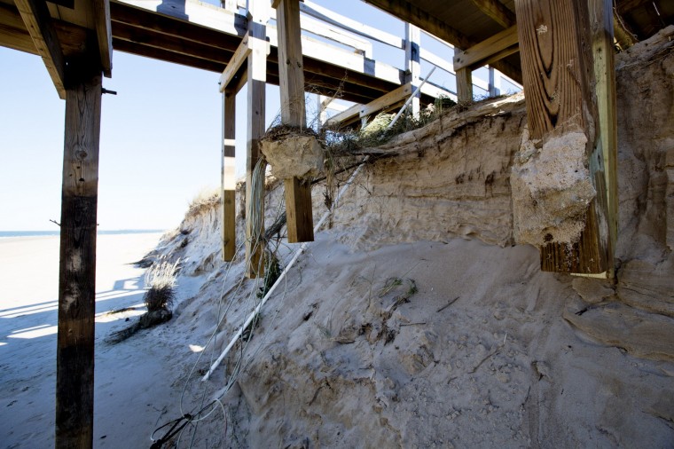
The pillars on a boardwalk at the Cape Henry beach in Virginia Beach are exposed Monday, Nov. 3, 2014, after recent storms that washed away about 15 feet of dune. (Thé N. Pham | The Virginian-Pilot)
A city beach replenishment last shored up the dune in 2010, said Mike Mundy, a city water resources engineer. The area is scheduled to get more sand in 2016.
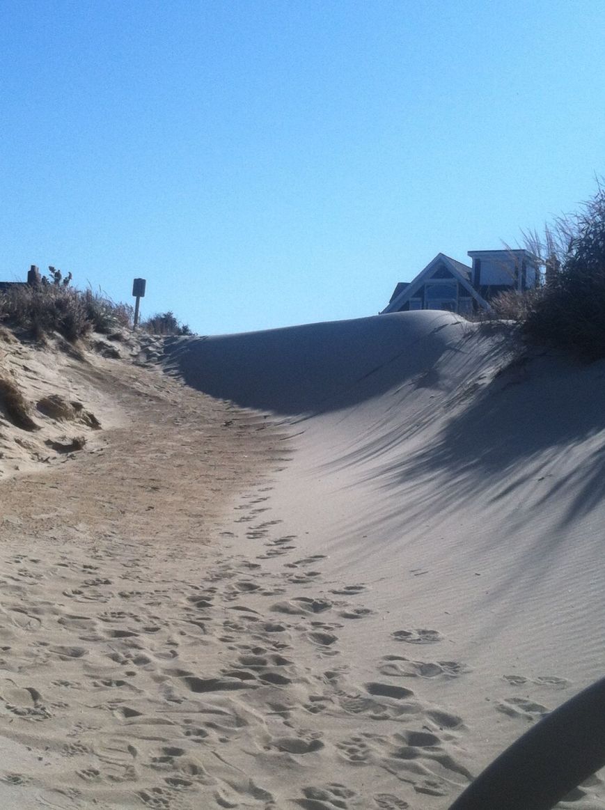
A wall of sand on the Jefferson-Raleigh Beach Path in Ocean Park. Photo swiped from Linda from OP Facebook Group page.
October 30th 2014 UPDATE:
Happy Halloween! Our news update for the bridge project is in NO WAY as frightful as the candy-craving minions who will be roaming the streets of Virginia Beach this evening!
The installation of the conduits beneath Shore Drive and East Stratford Street has been completed. For these next two weeks there are no scheduled daytime lane closures within the Lesner Bridge project limits.
Beginning on Monday, November 3rd, however, the Hampton Roads Sanitation District (HRSD) will begin their work on the existing sanitary sewer forcemain in WB Shore Drive. HRSD will mobilize two construction crews; one located at Shore Drive/Rockbridge Road and one at Shore Drive/Kleen Street. They will begin work on the active forcemain in order to remove from service the portion of this forcemain that crosses the existing westbound Lesner Bridge.
The first week of HRSD’s work will involve setting up their traffic control. None of this work will require long term lane closures on Shore Drive. There will likely be daytime lane closures the week of November 3rd as they setup the temporary barrier service on westbound Shore Drive at Kleen Street and build the temporary lane shift at Rockbridge Road.
The actual work to excavate, cut and cap the forcemain will take place the week of November 10th through Saturday November 15th. Restoration work of the roadway and work areas will take place the week of November 17th. All work, including equipment demobilization and removal of the temporary traffic control, should be completed by November 24th.
As for the latest bridge construction progress:
Ø Construction of the new bridge abutment “A” continues on the west side of the Lynnhaven Inlet. The first concrete pour on the new bridge abutment took place on Wednesday, October 29th. Placement of the reinforcing steel and formwork for the second tier of the abutment will take place the week of November 3rd.
Ø All of the drilled shafts at Piers 1 and 2 have been installed. Over the next two weeks the Contractor will mobilize equipment to Pier #3, the first in-water pier to be constructed on this project. Also within the next two weeks the Contractor will begin preparing the excavation at Pier #1 for the formwork of the concrete cap.
The temporary bulkhead at the Lynnhaven Dredge Material Storage Site (LDMSS) continues. The tie-back system on the new bulkhead is nearly complete. Construction of the tie-back and waler system on the temporary bulkhead will be completed by Wednesday, November 5th. Placement of the formwork and steel reinforcing for the concrete cap on the bulkhead will also continue through November 5th.
Wick drain installation for the new westbound bridge approach located on the east side of the bridge between Page Avenue and the existing bridge abutment continues. On the west side of the bridge – in front of 3556 On the Bay Condominiums – the subgrade has been prepared for the foundation of the new retaining wall. Between November 5th and November 7th the Contractor will begin to form and place the concrete footing support for the new retaining wall. Delivery of the first concrete panels for the new wall is expected Friday, November 7th.
On the east side of the bridge drainage work also continues. The new storm drainage structures are being placed along Cape Henry Drive in front of Bubba’s and the Lesner Inn. The temporary steel sheeting installed at the corner of Shore Drive and Vista Circle will be removed between November 5th and November 7th. After this is removed, work will begin to install 36-inch stormwater pipe from the structure to the existing 36-inch pipe located on the south side of Cape Henry Drive.
At some point during this construction Cape Henry Drive will be reduced to one lane and the Contractor will have to provide a flagger to control traffic on this road until the new pipe can be installed. Once we have a better idea of schedule for this work, we will issue another project updated with specific dates and estimated duration of the work.
Finally, unrelated to the bridge construction but contributing to the amount of construction work now taking place within the Lynnhaven Inlet and along Cape Henry Drive, is the Dominion Virginia Power (DVP) transmission line rehab work. This is just an FYI to all of you who are curious as to what is going on with the old transmission lines and towers.
DVP is replacing a number of wooden poles and structures along Cape Henry Drive and along the south side of Shore Drive near the Lynnhaven Boat Ramps with galvanized steel monopoles. They will also be installing two new transmission line towers to replace the two aging towers that are currently located in the Lynnhaven Inlet. The new tower on the east side of the inlet (by the Virginia and Maryland Pilots Association) will be installed approximately 210 feet east of the current tower location. The new tower on the west side of the inlet (Lynnhaven Boat Ramp) will be installed approximately 25 feet west of the current tower location. This will result in a new tower spacing of 810 feet that is significantly greater than the current 575 foot spacing.
That’s it for now. Have a safe driving weekend, and keep an eye out for those munchkins roaming the streets tonight!
-Chris
Christopher J. Wojtowicz, P.E.
Project Manager
City of Virginia Beach
Department of Public Works
Municipal Center-Bldg 2
2405 Court House Drive
Virginia Beach, VA 23456-9031
Phone: (757) 385-5785
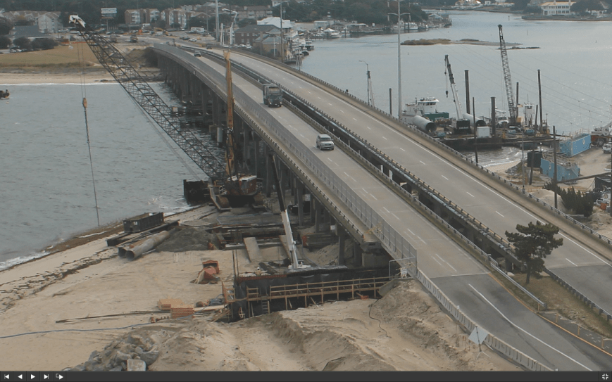
Zoomed in screen shot of construction cam photo taken at 10am OCT30 2014
That means you!
One of the reasons you still have time to comment is the work that Shore Drive Community Coalition – your neighbors – does to ensure We The People have a stronger voice.
Updates, info & more at VBGov.com.
Virtual Town Hall to share your input now. 
Have a voice in your neighborhood now!
October 17 2014 UPDATE:
Expect more daytime lane closures today, as well as Monday and Tuesday of next week on eastbound Shore Drive between East Stratford Street and the Lesner Bridge.
Today, October 17th and Monday October 20th, the electrical contractor will complete the boring of the new electrical conduit beneath East Stratford Street from the Sushi Restaurant to J&A Racing. Then on Tuesday October 21st the contractor will repair several potholes that have formed on Shore Drive east of East Stratford Street.
*** This work will require a SINGLE LANE CLOSURE on eastbound Shore Drive between East Stratford Street and the Lesner Bridge between the hours of 9:00 am and 3:00 pm for each day of work.
During this work, a police officer will be located at the intersection of Shore Drive and East Stratford Street to assist with vehicles entering and leaving East Stratford Street from Shore Drive.
The last project update mentioned that several recently placed concrete traffic barriers located on westbound Shore Drive between Page Avenue and the Lesner Bridge had to be replaced and would also require a daytime westbound lane closure to do this work. In lieu of replacement, the contractor is considering repair of these three temporary barriers. Because of that, no daytime lane closure on westbound Shore Drive at Page Avenue is planned at this time.
As for the latest progress:
Construction of the new bridge abutment “A” continues on the west side of the Lynnhaven Inlet. Formwork for the new westbound bridge abutment is now being constructed and is expected to be completed by October 24th. Concrete for the new abutment will likely be placed the week of October 27th.
Two of the four 4’ diameter x 95’ deep shafts have already been constructed at bridge Pier #2. Construction of the two remaining shafts at Pier #2 will be completed by the week of October 20th.
The temporary bulkhead at the Lynnhaven Dredge Material Storage Site (LDMSS) continues. The tie-back system on the new bulkhead will begin to be installed the week of October 20th and is anticipated to be complete by Friday, October 24th. The formwork for the concrete cap on the temporary bulkhead will likely be completed by October 31st.
Grading and preparation of the new westbound bridge approach located on the east side of the bridge between Page Avenue and the existing bridge abutment continues. The contractor is currently excavating the foundation for the new retaining wall that will be installed between 3556 On the Bay Condominiums and Shore Drive.
They also are continuing to install wick drains in the westbound bridge approach area between Page Avenue and the bridge. (“Wick Drains” are being used to accelerate the consolidation of a soft, compressible clay layer that exists approximately 50 feet below grade. As we place select fill material to build up the new bridge approaches, we want to accelerate and greatly increase the consolidation and settlement of this soft layer prior to building the new roadway).
We will continue to keep you informed of our progress as we move forward with this important project.
Have a safe driving weekend!
-Chris
Christopher J. Wojtowicz, P.E.
Project Manager
City of Virginia Beach
Department of Public Works
Municipal Center-Bldg 2
2405 Court House Drive
Virginia Beach, VA 23456-9031
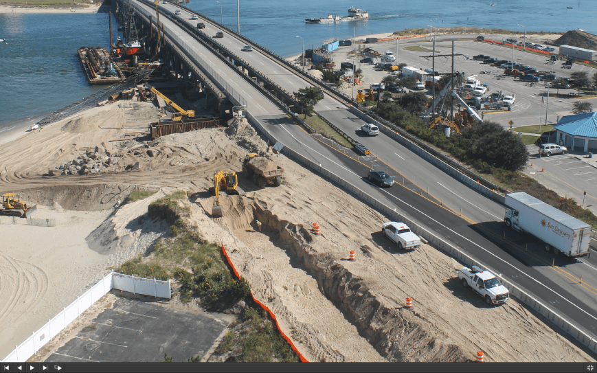
Zoomed in screen shot of construction cam photo taken at 2pm OCT17 2014
Bad accident.
Happening now 550pm.

 #WeLoveShoreDrive