One idea presented by budget staff is to use $7.3 million of the $27.3 million light rail fund to jump-start paying for some of the drainage projects. In addition, 1.8 cents of the real estate tax rate that is going toward light rail could be redirected to pay for stormwater improvements.
That would require City Council approval.
Category Archives: Environment

Update on CRS
What’s the CRS again?
Community Rating System (CRS) is to reward communities that are doing more than meeting the minimum NFIP requirements to help their citizens prevent or reduce flood losses. The CRS also provides an incentive for communities to initiate new flood protection activities.
Update from Whitney McNamara, City of Virginia Beach Planning and Community Development:
City Council was briefed on CRS earlier this year – in August. At that time, no formal decisions were made, it was more to make them aware that it is a program the City is exploring. At this time, we are still awaiting final approval of the Hazard Mitigation Plan from FEMA and adoption by City Council. Once it is officially adopted, the plan can be sent to FEMA’s CRS consultant to review for CRS Compliance (FEMA is currently reviewing and approving it as a Hazard Mitigation Plan, not a Floodplain Management Plan). A Floodplain Management Plan is a minimum requirement for participation due to the number of repetitively flooded structures in Virginia Beach. If it is approved as a Floodplain Management Plan, the CRS program will be taken back to Council for a final decision to join or not. If and when we get the official go ahead, it is an 18-24 month process before Virginia Beach will officially be in the program, so the earliest residents would begin to receive the discounts would most likely be in 2019.
So it looks like the earliest you could start seeing Flood Insurance Premium discounts is 2019 if the COVB participates in FEMA’s CRS.
Additional resources:
- 500 Series: Flood Damage Reduction
(Pay special attention to Activity 510)

One slide from presentation
NFIP CRS City Council Presentation August 9th 2016 PDF (11pages)
More info at FEMA here:
BRIDGEWALK CANCELLED #LESNERBRIDGE
You can imagine how frustrating this is.
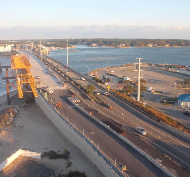
UPDATE: Due to a water main break that has created some damage to the new roadway at Page Avenue, this area will still be an active construction zone until the repairs are completed and therefore off-limits to pedestrians. Because of that, “walkover” of the new span of Lesner Bridge – scheduled for this Sunday – is CANCELLED.
Brock Environmental Center vandalized last night. Can you help?
Info so far:
Good morning all. We don’t know the exact time frame, but the Brock Center was vandalized on the concrete pilings, doors, and wind turbine. It was found this morning, and it appears there is one girl in particular being bullied. A few names were mentioned and some numbers were used. If you have a child with any of these names and they are getting bullied or you have any information, please reach out to us. We are hoping to catch the kids that did this.
We also heard from a visitor that there were kids on the roof this weekend who appeared to be of middle school age.
The numbers written were 220276 and 220270.
The names written included:
Jacob Santorius (or Sartorius)
Jacum
Kyra (most frequently found with strong, vulgar language)
KatelynIt appears that many of the places Kyra’s name was mentioned were scratched out with a different marker, so she may have been with or near them.
Please call the Brock Center with any information at 757-622-1964. Thank you.
Meeting tonight in Ocean Park about filling in wetlands, buffer …

FEMA/USACE Debris Removal Guideline
The following FEMA/USACE Debris Removal Guideline may be helpful for those that have major clean up as a result of Hurricane Matthew.
You can also click on the following link to read the entire 51 page controlling FEMA document – fema_debris_removal_guidelines

If you click on the image above it will take you to a printable picture of the flyer. It looks best if you print it in landscape format.
“I wish them luck,” Whittecar said. “They are essentially trying to lower the water table.” He added: “It will eventually drop. It’s likely to take awhile.”
Article and more pics at Pilotonline.com:
He described the whole Cape Henry area as “one big, thick pile of sand.”
“It just soaks up the water that falls on it,” he said.
Water is stored in the space between the sand grains.
“Sediment grains, whether they are like beach balls or little round BBs, those curved surfaces leave a lot of space in between,” Whittecar said.

Photo Credit” Virginian-Pilot
It was clear in both directions this afternoon.
Matthew Updates at VBGov.com including Forms.
Property Damage Form
If your home or business suffered damage from Hurricane Matthew, PLEASE CALL YOUR INSURANCE COMPANY FIRST! Your agent can determine what is covered by insurance.THEN, please fill out this form. It will help Virginia Beach property owners qualify for FEMA assistance. The city must demonstrate a certain amount of damage before FEMA will offer help to individual property owners. Every report helps our city qualify for assistance…
Electronic and Hazardous Recycling Event – Sat. Sept. 24th from 10am-2pm @ Virginia Aquarium
From personal experience, this is a wonderful service. It’s well run, quick and FREE. Please use it if you have items that would be better recycled than poisoning our earth in a landfill. Click here for more details
The Virginia Aquarium & Marine Science Center, in partnership with Goodwill Industries, the City of Virginia Beach Public Works and TFC Recycling, will offer its semi-annual E-cycling event Saturday, September 24, 2016 from 10 a.m. – 2 p.m. at the Virginia Aquarium East Parking Lot.
Acceptable personal electronic recyclable items include:
- Personal computers and laptops
- Telephones, cell phones and PDA’s
- Printers
- Televisions smaller than 32″
- Circuit boards and components
- Monitors and flat screens
- Fax machines
- Stereo equipment and game systems
- Regular recycling materials such as newspapers, bottles and cans will also be accepted.
Acceptable Household Hazardous Waste items include:
- Up to five gallons of liquids or up to 75 pounds of dry materials
- Aerosol spray cans
- Automotive fluids
- Batteries: Alkaline (AA, AAA, C, D), Boat, Car, Camera, Cell phone, Hearing aid, Lead acid, Lithium, Rechargeable, Trucks
- Herbicides
- Household cleaners
- Gasoline (up to 5 gallons)
- Fertilizer
- Pool Chemicals
- Light bulbs – small quantities of CFLs or fluorescent tubes
- Oil and water based paint
- Pesticides
- Propane tanks (small – up to 20 lb. capacity)
- For further tips visit www.VBgov.com/landfill
“The survey questionnaire (see link below) provides an opportunity for Hampton Roads residents to share opinions and participate in the ongoing mitigation planning process taking place with Hampton Roads communities.”
Start here at VBGov.com to complete the: Hampton Roads Hazard Mitigation Plan Survey.
Both the survey and the August draft will be “live” through August 17, 2016, at which time we will compile the survey results and comments received for the committee to review and act upon.
The survey will be available through August 17, 2016. Additional opportunities to review the draft plan and provide written feedback, or to attend a public meeting are in the planning process. Stay tuned for additional information.
Emphasis ours.
The Draft Plan includes language like:
Mitigation actions should go beyond recommending structural solutions to reduce existing vulnerability, such as elevation of structures, retrofitting, and acquisition projects. Local policies that guide community growth and development, incentives tied to natural resource protection, and public awareness and outreach activities should be considered to reduce the region’s future vulnerability to identified hazards.
This afternoon before the City Council Meeting tonight there is also a briefing on the Community Rating System:
MAYOR WILLIAM D. SESSOMS, JR. PRESIDING
I. CITY MANAGER’S BRIEFINGS – Conference Room – 4:00 PM
. . .
B. NATIONAL FLOOD INSURANCE COMMUNITY RATING SYSTEM and
REGIONAL HAZARD MITIGATION PLAN Whitney McNamara – Planning
. . .
View 1 page PDF of City Council Agenda here.
More Posts at SDCC.info about Community Rating System or CRS here.
More info at SDCC.info about Flood Mitigation at our Hot Page.
Questions?
Please add them in Discuss below.
Changes to dredging program. Not near Bayfront area.
Another 16 homes were taken out of the Hurd’s Cove district because permitting agencies said it would cause too much damage to wetlands, said coastal manager Phill Roehrs.
The city can work on some wetlands, Roehrs said, but federal environmental agencies require the city to replace them somewhere else. Replacing the damaged wetlands in Hurd’s Cove would almost double the cost of the $2.9 million dredging program.
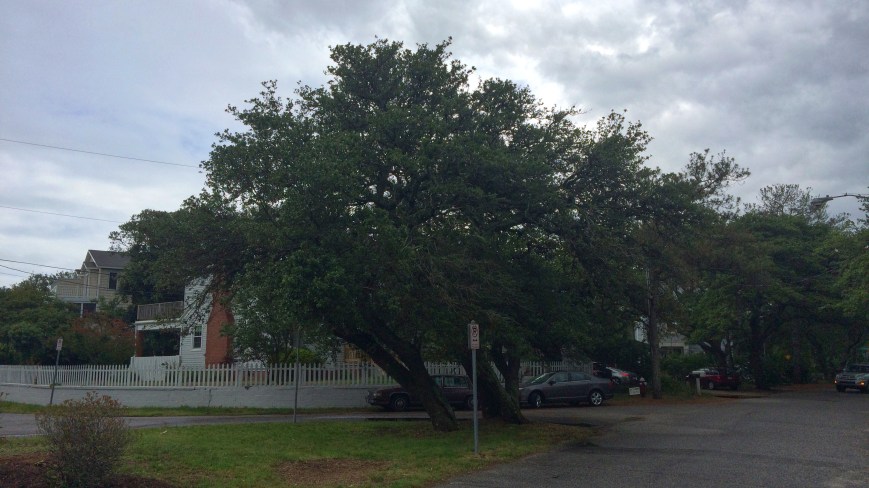
Live oaks on triangle at Tazewell & East Stratford Road in Ocean Park being cut down. Teachable moment opportunities.
From City Arborist:
I wanted to let you and the SDCC know that three Live Oak trees at the intersection of Tazewell Rd. and East Stratford Rd must be removed soon by Virginia Beach Landscape Management. The city has been monitoring the trees for a few months and carried out crown cleaning. However the soil in the median where the trees are growing is extremely compacted, and this has led to the decline of the trees and canopy dieback. A strength test was performed on these trees which revealed decay within the shell walls of the trunk. We will be replacing these trees with three more Live Oak trees in our next planting season. One tree will go into the center of the median where the soil is less compacted and the other two trees will be planted nearby.
Thank you for helping us inform the neighborhood residents. Please let me know if there are any additional questions.
Best wishes,
Susan
Susan French
City Arborist
Virginia Beach Parks & RecreationLandscape Management Division | 4141 Dam Neck Road | Virginia Beach, VA 23456
Phone 757.385.4076 | Fax 757.427.1895 | sfrench@vbgov.com | VBgov.com/Parks

A couple goals discussed includes staging the live oak lumber some place dry to cure it to create art.
You might have seen live oak lumber used in Brock Environmental Center that was saved from live oaks cut down for a development in Ocean Park to be built. (View some of the art at this link in SDCC.info.)
Other teachable moment opportunities include clearly illustrating why the live oaks had to be cut down and how to ensure yours stay healthy.
COVB heads to court over beach replenishment
Read story at Pilotonline.com.
The filing names more than 50 property owners near the Chic’s Beach shore, but only a handful are actively contesting the city’s assertion. Many residents declined to sign paperwork to opt out of the lawsuit and accepted default status, meaning they would accept whatever the court’s decision is, Boynton said.
SDCC General Meeting – Monday May 23rd at 7:30pm
Click here for a printable version of the agenda – 5.23.16 SDCC Agenda
SDCC General Meeting Agenda
Monday May 23, 2016 from 7:30 to 9:00pm
Ocean Park Volunteer Rescue Squad Hall
(parking in back, on side streets and across Shore Drive)
Special Presentations – No scheduled presentation. This time will be used to discuss which future presentations should be pursued. Possibilities include:
- City’s Urban Forest and Tree Oversight (Susan French, City Arborist)
- Long Range Storm Water Plans for Shore Drive East of Lesner Bridge
- Update on City’s pursuit of Community Rating System (CRS), a National Flood Insurance Program
- Update on Shore Drive Safety – Have improvements helped reduce accidents/incidents?
- Any other community concerns?
Officer’s Reports
Secretary – David Williams; Treasurer’s Report -Kathy Pawlak; Vice President – Wally Damon; President – Todd Solomon
Old Business-
Marina Shores Proposed Development – Update on proposal to rezone the site and construct 261 apartments. City’s Planning Department evaluation update. When will the project go before the Planning Commission?
Beach Event Houses – Update from the Beaches & Waterways Commission overseeing this evaluation.
New Business –
Bayfront Advisory Commission News – Mr. Wally Damon will update us on the actions of the Bayfront Advisory Commission.
Community Concerns – Does your neighborhood/condo have any issues that have come up that need help or may be a warning to others?
Next SDCC Meeting – Monday June 27, 2016
“The Brock Center intends to be an educational platform for all participants and visitors to better learn and act in responsible ways. The result is an exceptionally informed and inspired constituency that values the Bay and its watershed as a living, connected system.”
Read & view photos of Case Study entitled The Chesapeake Bay Brock Environmental Center:
This site is a fantastic location for an Environmental Education Center, as it provides a wealth of opportunities to study both the ongoing restoration of the landscape and the interface where the land meets the water. The center will be an active demonstration site for important and relevant restoration projects, including living shorelines, oyster, wetland, and other habitat restoration, as well as water quality improvement initiatives.

Photo Credit: International Living Building Institute
There are 2 errors in the Case Study.
International Living Building Institute have been notified.
Can you find them?
Anyone know who this kayaker is?
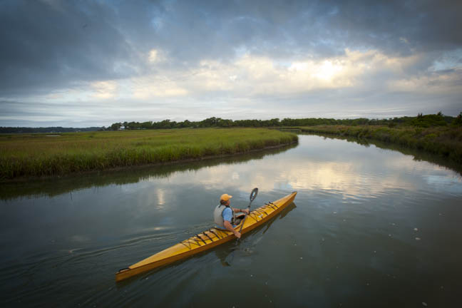
Who is this?
He was photographed by John Henley for Trust for Public Land a few years ago for an article about the preservation of Pleasure House Point.
Congratulations to the newest Certified Living Building in the world – Brock Environmental Center on Pleasure House Point
From their Facebook page this morning:
We are incredibly excited to announce to you that CBF’s Brock Environmental Center has been named the newest Living Building in the world!
The Brock Center has officially met all requirements of the Living Building Challenge through the International Living Future Institute! Thank YOU for your support in making this happen–truly a celebration for all!

Congratulations to everyone who helped make this achievement possible!
Learn more about the Living Building Challenge.
Not all of Pleasure House Point is permanently preserved yet.
View map at our Pleasure House Point page.
Cape Henry Beach Replenishment
The following notice was graciously sent to SDCC by Mr. Phill Roehrs, P.E. Water Resources Engineer with the City of VB Public Works Engineering. Thank you Phill for keeping us up to date.
Dear Shore Drive Residents:
We wanted to let you know about an upcoming truck haul of sand from the City’s stockpile south of the Lynnhaven Boat Ramp and Beach Facility to a section of Cape Henry Beach.
As you know, the sand stockpile area has been the repository for sand dredged from the Crab Creek channel in recent years. Portions of Cape Henry Beach have experienced erosion over the previous winter, and would benefit from the placement of the sand dredged from Crab Creek.
There is also a need to remove sand from the stockpile area to create capacity for future dredging of Crab Creek and to help alleviate space issues at the staging area for the Lesner Bridge Replacement Project.
As such, the City has begun coordinating a truck haul of up to 30,000 cubic yards of material from the sand stockpile to a portion of Cape Henry Beach for purposes of beach replenishment.
Some of the details are:
Ø Trucks will begin hauling sand as early as May 9, 2016, in an attempt to finish the beach work prior to Memorial Day.
Ø The replenishment area will be the area to the west of the Lynnhaven Fishing Pier.
Ø The Jade Street beach access will serve as the vehicular access point for trucks hauling sand to the beach.
Ø This truck haul will result in increased storm protection for portions of Cape Henry Beach just prior to the upcoming hurricane season, and will serve to nourish the beach westward to the Lesner Bridge by natural drift.
If you have any questions or would like further details about this project, please contact Thomas Gay via email at tgay@vbgov.com, or by phone at 385-4838.
Thank you for your time and please share this information.
“Help is on the way, as surveying is complete on a $1 million project to alleviate flooding in several neighborhoods south of Shore Drive. Installation of three sluice gates in the Cape Henry Ditch will commence shortly.”
Check article and photos at Pilotonline.com:
When the project is complete in January 2017, sensors that monitor water height along the ditch will signal the gates to move up or down, a process that typically takes 10 to 15 minutes, according to Mike Mundy, water resource program manager for the city. Though the gates are primarily for protection from tidal water, they will also be monitored to prevent heavy rainfall from causing flooding when they’re closed.
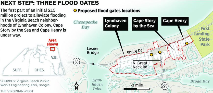
Graphic Credit: Virginian-Pilot
“These funds have allowed us to build 58 acres of sanctuary oyster reef in partnership with the US Army Corps of Engineers in the Lynnhaven River and stock them with 20 million spat on shell oysters. These sanctuary reefs have contributed greatly to the resurgence of our native oyster population and to the improvements in water quality and habitat.”
Obviously a clean Lynnhaven River makes the world a much better place for all of us!
Learn more about the Virginia Beach Oyster Heritage Fund at LRNow.org:
The shells that have accumulated at the landfill over the past six years are slated to be used to build a 1.5 acre sanctuary reef in Eastern Branch of the Lynnhaven River in spring 2017.

“Have you ever seen a site like this anywhere in the world?” McAuliffe asked.
Everett said the Brock Center has exceeded her expectations most in drawing people to it. The foundation invites visitors to come inside, and in its first year 24,000 did – four times more than predicted.
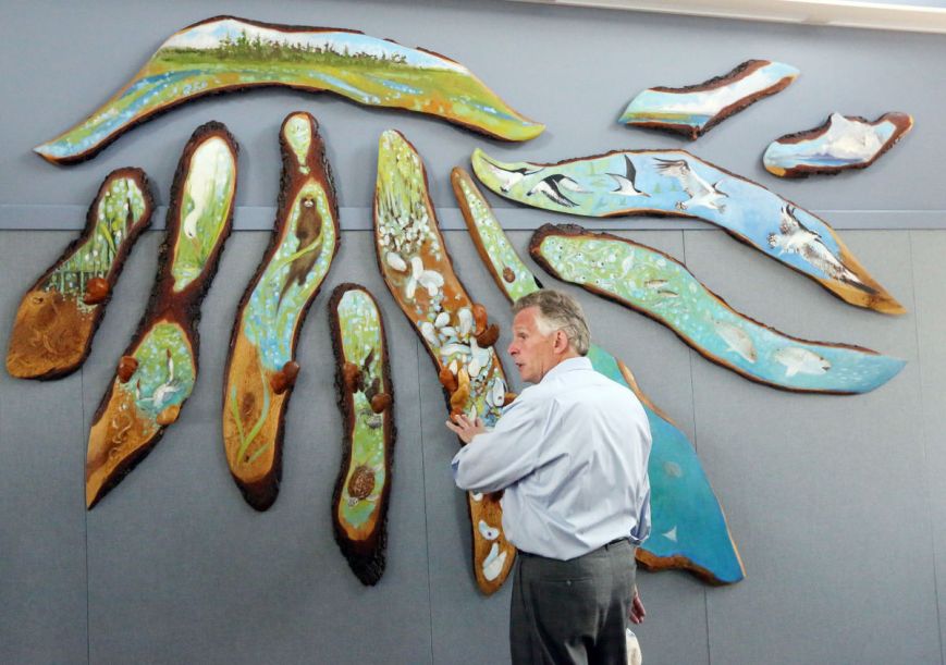
Gov. Terry McAuliffe looks at art made of a live oak tree during a tour . . . Photo Credit: Steve Early | Virginian-Pilot
A bunch of us have always thought the “site” had great potential. ;-)
Article in Virginian-Pilot Feb 2003.
