VBCPS is now accepting applications from current 10th grade students interested in attending the Environmental Studies Program, a new innovative program opening at the Brock Environmental Center in September 2020.

10th graders, start here to begin application process:

Application Process

Before entering grade 11, students will apply for admission to the program in the fall of their sophomore year. An essay formulated around the topics of Sustainable Economics and Business Innovation, Social Sustainability and Environmental Sustainability and Natural Resource Stewardship will be included in the application and will be used to identify candidates who show a passion for and interest in the fields of study. . . .

Editors note: Dream big and never quit. You never know what you’ll be able to accomplish in spite of it being “impossible”.

Sea Level Wise Adaptation Strategy Public Meeting schedule includes one near Shore Drive!

Schedule at VBGov.com:

February 15, 2020 – Cox High School – 2425 Shorehaven Drive – 10:00 AM to 12:00 PM

View Comprehensive Sea Level Rise page at VBGov.com.

It is well documented that sea levels have been rising over the last century. This impacts coastal communities as virtually all human infrastructure will experience some risk. The story of Sea Level Rise and how it effects the City of Virginia Beach is detailed below:

The threat of sea level rise is a very real one, and it’s one that coastal regions like Hampton Roads must face and prepare for. . . .

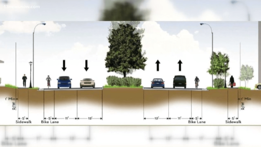
Graphic from just one idea that was discussed.

What Would You Like to See in a New City Manager?

The closest public input meeting you could attend was no where near Shore Drive community. Again.

You can take a Survey created by the recruiting company searching for our next City Manager online however and we encourage you to do so.

Start at this link for their SurveyMonkey.com survey.

Questions include:

Which three of the following leadership traits do you believe are most important for the next Manager to possess?

Which five of the following abilities and skills do you believe are most essential to perform the work of the City Manager?

What are the top three challenges you think will face the new City Manager?

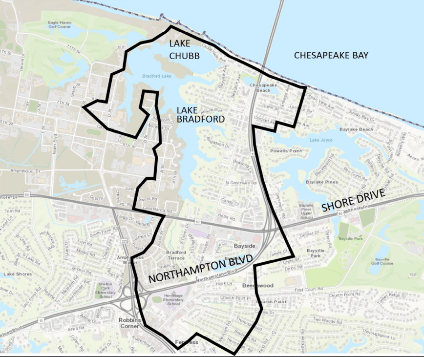
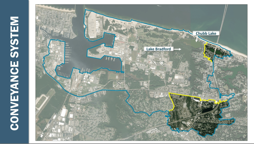
LAKE BRADFORD / CHUBB LAKE DRAINAGE STUDY November 2019 | CIP 7-053 presentation from Open House, and Survey due DEC 12

Visit main page at VBGov.com.

The City of Virginia Beach’s Department of Public Works is seeking public input on repetitive residential and roadway flooding within the area adjacent to Joint Expedition Base (JEB) Little Creek, Chesapeake Beach, Northampton Boulevard, and Shore Drive.

Start Official Survey here.

Survey will CLOSE DEC 12

Download Official Presentation

An Open House Meeting was held by the Virginia Beach Public Works Department, November 14, 2019, at the Bayside Recreation Center.

Official CIP 7-053 Page.

City District(s): Bayside

This project will be for the design, acquisition, and construction of stormwater and related roadway improvements necessary to alleviate widespread flooding due to moderate rain events, and during periods of significant high tides from the Chesapeake Bay. Lake Bradford and Lake Chubb are tidally influenced by the Chesapeake Bay via their outfall drainage ditch system that runs through Joint Expeditionary Base – Little Creek. The eastern portion of Stormwater Watershed 31 including areas west of Northampton Blvd and portions of Church Point and Thoroughgood drain into Lake Bradford before they drain through Little Creek and into the Chesapeake Bay. The drainage improvements include, but are not limited to, storm drain pipe and structure improvements, additional stormwater culverts under multi-lane arterial roadways, tide control devices such as mechanized sluice gates, stormwater management pond improvements and, potentially, some channel/ditch clearing.

“We would really like to see the city step up and take care of this area and implement Phase 4 and implement Phase 3 now,” said Ocean Park Civic League President Andrew Broyles.”

View video & story by Reporter Ali Weatherton at 13NewsNow.com.

“nothing really safe there for pedestrians”

And:

“Shore Drive is the 3rd most traveled road in Virginia Beach”

Did you know it’ll be ~20 years between completing only 2 Phases of bringing Shore Drive up to the standards of the rest of the city.

Let’s step up and take care of this area now.

Have ideas which VB you want to live in? Take the Comprehensive Plan survey NOW to help CoVB set a vision for a city you want to live in.

Start here to take the Official CoVB Comp Plan survey.

Questions include:

For the local economy to grow, what job sectors would you like to see develop or expand? (select all that apply)

Which of the following were reasons you chose to live where you do now? (select all that apply)

What 3 things would you change about Virginia Beach?

Start here to start the Official CoVB Comp Plan survey.

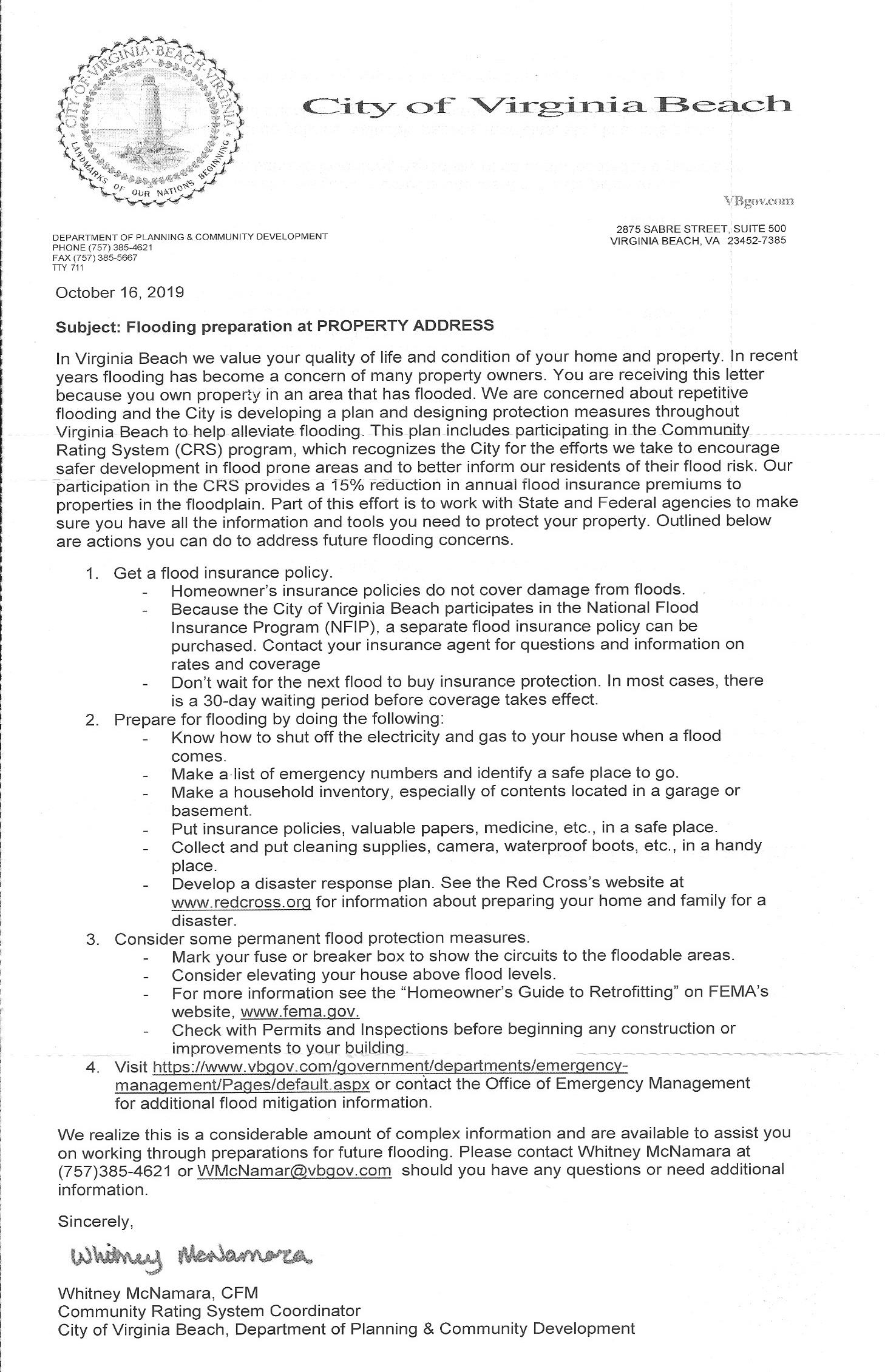
FEMA/HUD Community Rating System (CRS) City Mailer

As part of the CRS requirement, the City of Virginia Beach must provide the community with information and updates for the FEMA/HUD program.  If you live in a designated flood zone, you should have received the following notice.  It provides good information and links to other sites that are very helpful.  One of the biggest changes you should already be seeing is the 15% discount in your flood insurance premiums.  As the City continues to do more regarding flooding and storm water improvements, this discount should also increase to 20% and maybe even 25% over the next several years.

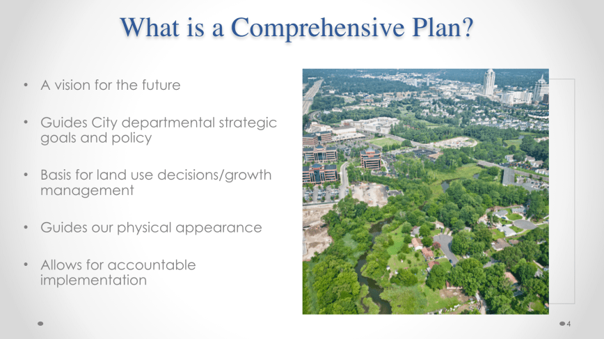
Comp Plan presentation slideshow from our recent September meeting

Learn more at VBGov.com about YOUR role in shaping the Comprehensive Plan.

Download Comp Plan slide show. (PowerPoint is 7.9MB)

Contact info for Mr Mark Shea Comprehensive Planning Coordinator​​ (757)​ ​385-2908 or meshea@vbgov.com.

Open House Public Meeting to be held by the Virginia Beach Public Works Department for the Lake Bradford/Chubb Lake CIP (CIP 7-053).

The meeting will be held on Thursday, November 14th from 6:00-7:30pm at the Bayside Recreation Center at 4500 First Court Road.

Link to Official City of Virginia Beach, VA Public Works Capital Project Detail Sheet 7.053.000: Lake Bradford/Lake Chubb CIP page.

Official Lake Bradford & Lake Chubb Stormwater page at VBGov.com.

Lake Bradford & Lake Chubb Stormwater

Project Manager contact info:

Matthew Richardson, P.E.
Project Manager
Department of Public Works
Stormwater Engineering Center
City of Virginia Beach
mrichardson@vbgov.com
Phone: (757) 385-8005

Thanks to Mr Richardson for the email of Open House & CIP details!

“Looking like the storm surge and Friday afternoon’s high tide (4 pm here in Norfolk) will coincide – unfortunately.”

Periodically we share updates from some really hard workers.

From an email by Skip Stiles of Wetlands Watch:

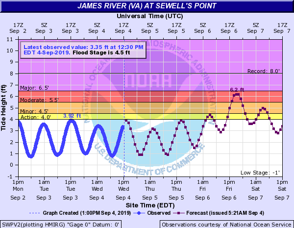
Looking like the storm surge and Friday afternoon’s high tide (4 pm here in Norfolk) will coincide – unfortunately. Wind from the NE starts cranking at noon Friday around 30 MPH. 1.5″ of rain on Thurs will be followed by another ~4.5 inches on Friday. Unfortunate coincidence of events.

Newest word from Jeff Orrock at NWS Wakefield is that the tidal waters are likely to hit 6.5 – 7 feet. That’s somewhere between Matthew (6 feet above Mean Lowe Low water) and Irene at 7.6 feet. Plan on 7 feet and hope for less? But the rain will be an issue on all those poorly draining streets and those places where stormwater lines bring water back up into the neighborhood.

Closings are already happening – ODU just announced a Friday closure.

ON THURSDAY – put your cars up somewhere higher if your street floods. Looks like we’ll get a pass on the wind – 30 MPH.

ON FRIDAY – stay home
…except you, Jeff. Thanks for the long hours

So – Friday afternoon flooding will be bad = tidal flooding up to 7′ (getting close to Irene), rain flooding will be bad everywhere. Wind will not be that strong but downed trees limbs will be a reality. Kids will probably get the day off Friday, so stay home if you can.

Skip
(yes, I know it says 6.2 feet on this chart but if you’re smart you’ll plan for higher because it will probably go closer to 7′)

Citizen Input Still Sought Regarding Sea Level Rise Plan – Take a Survey to Help

In addition the recent public input meetings held by the City of Virginia Beach, the City is asking citizens to take an online survey to help capture your ideas and comments on the Draft Sea Level Rise and Recurrent Flooding Plan.  The survey can be found at the following link.  Please feel free to share this survey with anyone else that may live or work in Virginia Beach.

Click here or on the image above to access the survey https://sites.wp.odu.edu/asert/vb2019/


New Sea Level Rise (SLR) Meetings Scheduled – Please Attend One To Make Your Voice Heard

City of Virginia Beach — Comprehensive Flooding Response Plan Meetings
Four Meetings, Each in a Different Area of the City
The City Wants Your Input
When it comes to Sea Level Rise…
What actions can we take as a community?

City Staff Members are teaming up with ODU to get your input at a series of community meetings!
What will you learn?
What is your flood risk?
What are the options for city wide response?
What can you do on your property that could help?
Hear about what the city is considering.

Give the City Your Opinion!
There will be interactive information plus children’s activities
and a drawing for a $50 and a $25 Amazon Gift Card

Meetings in red below are closest for Bayfront residents

Monday, July 29, 6-8 PM — Creeds Elementary School, 920 Princess Anne Rd
Tuesday, July 30, 6-8 PM — Thalia Elementary School, 421 Thalia Drive
Wednesday, July 31, 6-8 PM — Kellam High School, 2665 West Neck Road
Saturday, August 3, 10 AM – 12 PM — Cox High School, 2425 Shorehaven Drive

Can’t come in person? Participate online at http://shorturl.at/chKO8
Find out more about the flooding response plan at www.vbgov.com/pwslr
Email questions and comments to SLR-comments@vbgov.com

Cape Henry Beach Replenishment update

Two emails, one from Mr Adams Public Works COVB & one from Mr Tolson Army Corp.

Subject: FW: Update on Cape Henry Beach Sand Replenishment

Todd,

We will not be able to attend the SDCC meeting tonight. The attached map delineates the dredging and corresponding sand placement areas. The contractor began dredging and sand placement along Cape Henry Beach yesterday, Sunday June 23. The Cape Henry placement is scheduled to take 30-45 days to complete. The dredging from Broad Bay Channel will be placed in the Maple Street Dredge Material Management Area (DMMA) and the small amount of dredging in the Narrows will be placed on the park beach.

Please contact me should you have any questions or require additional information. For now, please direct any project concerns to my attention.

Respectfully,

Dan

Daniel F. Adams, P.E.

Coastal Program Manager

City of Virginia Beach
Public Works Engineering / Water Resources
Municipal Center, Building #2
2405 Courthouse Drive
Virginia Beach, Virginia 23456
Ph. (757) 385-4783
dadams@vbgov.com

And from Army Corp Project Manager:

Subject: RE: [Non-DoD Source] RE: Cape Henry Beach Replenishment – Project Update #1Subject: RE: [Non-DoD Source] RE: Cape Henry Beach Replenishment – Project Update #1

Mr. Solomon,

I apologize for I am out of town this week and unable to attend the meeting. Feel free to distribute my email for residents to reach out to me. To hopefully dispel any major concerns regarding what you mentioned below, we have language in our specifications that says the Contractor shall, to the maximum extent practicable, limit the construction noise on the beach from 7PM – 7AM.

In addition, Cottrell is a good contractor who has completed a lot of beach placement projects in the past, including this project (last time Cape Henry got material in 2009). This should make them efficient in the beach placement work and minimizing their noise disruptions. They brought a large dredge plant for this project, ~19″ discharge, so we expect them to complete work relatively quicker than what we originally projected. I haven’t received a project schedule in a couple of weeks but I estimate them to complete Cape Henry Beach work by end of July, maybe into the first week of August (the variance on this is high). The 500 foot fenced off construction sections of beach will probably be moving west to east at an average pace of 48 hours. Some sections will have more fill than others to achieve the desired consistent berm prism along the entire length of the beach placement area (a target elevation of +7 feet Mean Lower Low Water) and thus take longer.

Please tell the community to use caution when navigating vessels in the proximity of the dredge and dredge pipeline. Also, please inform residents to use caution around the beach placement construction areas. The Contractor will have watches for those who get to close to the construction zone. Please be aware and cautious of dredge pipe that lay on the beach and cross at areas that sand ramps have been constructed over the pipe.

Something that residents may not be aware of that could be communicated at the meeting and limit confusion is that the sandy dredged material placed on the beach may not look like the present material. It is likely to be significantly darker and smell (the smell is contributed to any organic material that has accumulated on the bottom of the Federal Project). The material will be bleached over time by sunlight and the smell will go away relatively soon as the organics are exposed to air and biodegrade.

Please let me know if you or the community have any questions.

Regards,
Chris

Christopher B. Tolson
Design Section, Operations Branch
Norfolk District, U.S. Army Corps of Engineers
Office: (757) 201-7012

Editors note: corrected formatting errors this morning.

Dewberry Public Hearings scheduled this week are postponed.

Today at Cox High School

June 3, 2019 – Kellam High School (Southern)

June 5, 2019 – Princess Anne High School (Lynnhaven)

June 6, 2019 – Creeds Elementary School (Southern)

Note: sent with our Take Action Now Category so notice goes out asap.

PUBLIC FEEDBACK REQUESTED for Public Works DRAFT DESIGN STANDARDS MANUAL which will take sea level rise into consideration “for the development of both public and private projects within the City”

Visit VBGov.com Public Works Specifications and Standards page to learn more.

Public Works Specifications and Standards are the technical requirements, policies and procedures for design professionals to prepare plans and reports necessary for the development of both public and private projects within the City.

If you want to affect future development in Virginia Beach, we highly recommend getting familiar with the official city documents, attend the public hearing and provide feedback online.

The public review and comment period will remain open through June 30, 2019. Additionally, a public meeting will be held to discuss the draft document on Thursday, June 13th at the TCC ATC, 1700 College Cresent in the Theater from 9:30 am to 11:30 am.​

Forward written comments to PWDesignStandards@vbgov.com.

Executive Summary

Download Executive Summary PDF here and view below.

City of Virginia Beach

Changes from the current Public Works Specifications & Standards Manual to the
Public Works Design Standards Manual, 2019

Executive Summary

April 23, 2019

The City of Virginia Beach is replacing the current Department of Public Works Specifications and Standards Manual (PWS&S) with a newly created document entitled Public Works Design Standards Manual, 2019. The PWS&S, which was first adopted by City Council in 1994 and includes several amendments, with the most recent being Amendment 9, May 7, 2015, includes standards, policies, procedures, specifications and details for private development as well as specifications and standards for public infrastructure design. The new Public Works Design Standard Manual, 2019, provides design standards for private and public infrastructure to be located in the City’s Right-of-Way and public easements. Many of the standards, policies and procedures applicable only to private development have been removed and will be administered by the Planning Department, Development Services Center (DSC).

The new Public Works Design Standards Manual, 2019, updates the PWS&S to current best engineering practices as referenced in local, state, and federal guidelines. Additionally, some chapters were simplified and outdated information was removed.

A detailed “Summary of Revisions” document has been created to show the specific changes to each chapter of the PWS&S. This document is available at https://www.vbgov.com/government/departments/public-works/standards- specs/Pages/default.aspx.

The following are highlights of some of the significant changes included in the new Public Works Design Standards Manual, 2019:

 Public Works Role in Private Development Review has been changed to assisting the Planning Department’s DSC technical staff with compliance and technical reviews.

 Stormwater Management. The PWS&S Chapter 8 has been re-written to meet the new DEQ stormwater management standards and criteria and also includes more stringent requirements relative to flood control. Some of the major changes/additions are the following:

• Updated precipitation data as shown in the document must be used in all designs. This equates to an approximate 20% additional precipitation (24-hour rainfall depths and rational method rainfall intensities) for the requisite design storm, over the current National Oceanic and Atmospheric Administration (NOAA) Atlas 14 data.

• The EPA’s Stormwater Management Model (SWMM) software modelling tool is required to be used for all designs of drainage areas equal to or greater than 20 acres.

• The City has (or will have in near future) completed SWMM models of all (31) drainage basins. Designers must use these models or obtain direction regarding the use of model data from the Public Works Stormwater Engineering Center.

• More specific requirements were added regarding Hydraulic Grade Line and Tailwater Criteria.

• All designs must address Sea Level Rise if the development or project drains to tidally influenced waters.

• A requirement has been added such that every design is required to address the influence of “Seasonal High Groundwater” on the project.

 Chapter 11 of the PWS&S (Site Plans and Subdivision Requirements) has been deleted. The requirements related to Site Plans and Subdivisions will be covered by other documents administered by the DSC.

 Most of Chapter 12 of the PWS&S (Coastal, Waterfront and Flood Plain) has been removed and will be covered in other documents and/or ordinances.

 Requirement was added such that the developer, contractor and/or permittee (at their own expense) will be required to perform a closed circuit television (CCTV) inspection of all constructed storm sewer pipes and culverts upon completion of construction, and repair all deficiencies found.

The draft Public Works Design Standard Manual, 2019, is made available to the public on the City’s website at: https://www.vbgov.com/government/departments/public-works/standards- specs/Pages/default.aspx, for a 60-day public review and comment period. Comments can be submitted to PWDesignStandards@vbgov.com. Additionally, a public meeting will be held to discuss the draft document. After the comment period has ended the comments will be addressed and the Public Works Design Standard Manual, 2019 will be presented to the City Council for approval.

Phillip D. Pullen, P.E. City Engineer

Virginia Beach wants to require developers to factor in sea level rise for new projects

From Pilotonline.com:

“Our goal, as engineers, is to prevent flooding,” said Phil Pullen, the city engineer who is leading the effort. “We’re treading new waters here — no pun intended.”

More, and better, information on a proposed development’s stormwater management plan could help prevent costly mistakes that were made in the past, he said. The often-cited example is Ashville Park, the Princess Anne subdivision that badly flooded during Hurricane Matthew in 2016 and will cost the city millions to fix.

And:

Pullen said he doesn’t know if all of the new stormwater requirements will ultimately pass, calling the process a negotiation with other city leaders and developers.

Photo Credit” Virginian-Pilot

“A newly-released study between Norfolk, Virginia Beach and the Navy recommends sweeping changes that would reshape areas from Ocean View to Sandbridge to prevent floodwaters from cutting off military bases.”

From Pilotonline.com:

The study’s findings carry far-reaching implications that could help shape costly infrastructure improvements in the future.

Proposed solutions would cost between a few hundred thousand dollars to more than $50 million for comprehensive improvements. The study, which is still a draft, looks at possible conditions — and the feasibility of potential fixes — under both 1.5 and 3 feet of sea level rise, focusing on chronic or nuisance flooding and not factoring in possible storm surge events.

It appears “Saturday, June 1 from 1 to 3 p.m. Cox High School 2425 Shorehaven Drive” has been added to the list.

The City Is Hosting a Series of Sea Level Rise Public Meetings at VBGov.com.

Virginia Beach Public Works has announced a series of public meetings with Old Dominion University in May and June concerning the City’s efforts in developing a comprehensive flooding response plan for sea level rise. Working with Dewberry, Public Works Engineering has been conducting studies and developing long-term plans to combat the growing risks and projected effects of sea level rise throughout the city.

Previously at SDCC.info.

Op-Ed from Chairman of Dollar Tree thanks SDCC for work on PHP so far

Read entire Op-Ed by Mr. Macon Brock at ePilot.com:

But thanks to this partnership and the many groups such as Shore Drive Community Coalition, Lynnhaven River NOW and other members of the community who worked hard to prevent intensive development on this land, it is encouraging to know this treasure will have the best, most capable, caring environmental stewards — if the rest of the needed funds to purchase the property materialize.

Saving Pleasure House Point

Virginian-Pilot, The (Norfolk, VA) – July 31, 2010

By MACON BROCK

THE PLEASURE House Point land deal between the city of Virginia Beach, Wells Fargo Bank, the Chesapeake Bay Foundation and the Trust for Public Land is exciting news and a tremendous accomplishment.

This excellent collaboration has been a godsend, and all involved deserve the community’s thanks for working diligently to try to preserve one of the last remaining undeveloped tracts of land on the Lynnhaven River. If it comes to pass, the protection and preservation of Pleasure House Point will be a wonderful asset to Hampton Roads residents and visitors for generations to come, and a vital boost to the water quality of our treasured Lynnhaven River and Chesapeake Bay.

However, we can’t celebrate yet because there are still millions of dollars that need to be committed by Oct. 31 in order to purchase the property and make sure this rare and precious open space is protected for good.

The conservation partners have applied for $3 million in federal grant money from the Coastal and Estuarine Land Conservation Program, but the grant’s success is still uncertain.

Three million dollars will go a long way toward the purchase and is a small price to pay to protect, restore and preserve such a vast area of wetlands, maritime forest and beautiful shorelines and waterways.

Each of us should encourage our congressional representatives to do everything they can to ensure that the CELCP is adequately funded at $60 million so the Pleasure House Point grant application has a better chance of being favorably received.

Pleasure House Point could have had a sad ending, with development destroying its natural beauty and introducing more runoff pollution into the Lynnhaven River and Chesapeake Bay.

But thanks to this partnership and the many groups such as Shore Drive Community Coalition, Lynnhaven River NOW and other members of the community who worked hard to prevent intensive development on this land, it is encouraging to know this treasure will have the best, most capable, caring environmental stewards – if the rest of the needed funds to purchase the property materialize.

This beautiful area provides a unique opportunity for the Chesapeake Bay Foundation and partners to conduct oyster restoration and research projects, preserve living shorelines and conduct upland restoration.

In addition, CBF can expand its award-winning Bay education programs for thousands of area students and teachers. Pleasure House Point is the perfect place to serve as a lower Chesapeake Bay community environmental/education center, an asset that would benefit everyone in this region.

The public wins by getting access to the wetlands, beaches and waterways. CBF and other local watershed groups will benefit from the ability to house offices and conduct programs and leverage much of the good work that many in the community have been partnering on for years. And the river and Bay will have improved water quality.

The city of Virginia Beach has done its part in looking out for the citizens’ best interests. The Chesapeake Bay Foundation’s vision and persistence have been paramount. The Trust for Public Land’s experience has been vital. And Wells Fargo Bank’s generosity and public spiritedness have been truly commendable, especially considering the unstable economy.

Let’s all help make sure this deal gets completed in time. Then, this pending ecological victory can finally be celebrated.