Periodically we share updates from some really hard workers.
From an email by Skip Stiles of Wetlands Watch:
Looking like the storm surge and Friday afternoon’s high tide (4 pm here in Norfolk) will coincide – unfortunately. Wind from the NE starts cranking at noon Friday around 30 MPH. 1.5″ of rain on Thurs will be followed by another ~4.5 inches on Friday. Unfortunate coincidence of events.
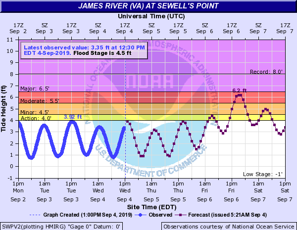
Newest word from Jeff Orrock at NWS Wakefield is that the tidal waters are likely to hit 6.5 – 7 feet. That’s somewhere between Matthew (6 feet above Mean Lowe Low water) and Irene at 7.6 feet. Plan on 7 feet and hope for less? But the rain will be an issue on all those poorly draining streets and those places where stormwater lines bring water back up into the neighborhood.
Closings are already happening – ODU just announced a Friday closure.
ON THURSDAY – put your cars up somewhere higher if your street floods. Looks like we’ll get a pass on the wind – 30 MPH.
ON FRIDAY – stay home
…except you, Jeff. Thanks for the long hoursSo – Friday afternoon flooding will be bad = tidal flooding up to 7′ (getting close to Irene), rain flooding will be bad everywhere. Wind will not be that strong but downed trees limbs will be a reality. Kids will probably get the day off Friday, so stay home if you can.
Skip
(yes, I know it says 6.2 feet on this chart but if you’re smart you’ll plan for higher because it will probably go closer to 7′)