We rewrote the city’s Comprehensive Plan to reflect your concerns about traffic, the environment and more.
Now we’re asking: Did we get it right? Does the revised Comprehensive Plan address the things you love and the things you want changed?
We’ve made it easy to respond. In fact, there’s an app for that — and community meetings.
Engage!
Thursday, Jan. 28 — Virginia Beach Convention Center, 1000 19th St.
To read the complete Comprehensive Plan, visit http://www.VBgov.com/2016compplan.
19. USE OF OYSTER LEASES FOR NAVIGATION PROJECTS
SPONSORED BY CITY COUNCIL MEMBERS, JAMES L. WOOD & JOHN E. UHRIN
| 26
Background Information:
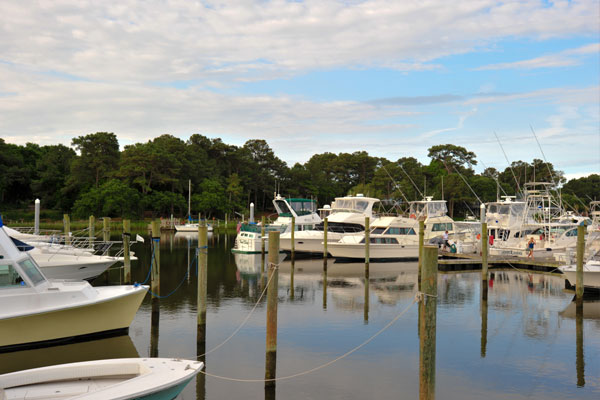
The City has numerous rivers and tributaries that require maintenance dredging. This includes both the main channels of the Eastern and Western branches of the Lynnhaven River and multiple navigation channels serving the multitude of neighborhoods of the fully developed watershed. Not only do these waterways provide access for homeowners to utilize their waterfront property, but these navigation channels support recreational boating for residents and visitors to the City in addition to serving water-dependent local businesses and watermen. Virtually all of the coves of the Lynnhaven were developed with navigation channels.
With the support of General Assembly legislation, Special Service Districts (SSDs) are being created to formulate neighborhood navigation dredging projects to reclaim those navigation channels that have filled with silt, mud and sediment foreign to the Lynnhaven’s past. Restoring navigable channels for these waterfront neighborhoods is a critical goal for the City, and the Navigation SSD program provides a venue to accomplish this. The silt, mud and sediment that have inundated this body of water contribute to degradation of the water quality of the Lynnhaven, which is condemned or restricted to oyster production in many areas. As a result of contamination, most oyster leases are unproductive or have costly restrictions and compliance measures before a harvest can be brought to market.
Restoring navigation channels is a part of the City’s effort to cleaning up the Lynnhaven River, but the widely popular SSD neighborhood navigation dredging program has been placed at risk due to 2014 legislation barring localities from exercising eminent domain to acquire portions of oyster leases of state-owned bottomlands, even if the purpose is navigational dredging. Due to guarantees made by the Commonwealth to the holders of oyster leases, consent from the oyster lease holder is required for any dredging permit issued by the Virginia Marine Resources Commission. The legal result of this requirement is that a single oyster lease holder with a nonproductive, vacant oyster bed in a condemned creek retains veto power over a navigation dredging project affecting hundreds of waterfront property owners and recreational boaters. The oyster leases cost $1.50 per acre/per year for a 10-year lease, and although there is a requirement that leases be worked for oyster production, there are generous exceptions for rivers like the Lynnhaven, where such production would not likely yield oysters. The proposed legislation is to promote a balance that allows the municipality and its property owners to maintain the navigation channels while providing fair treatment to active producing oyster lease holders.
Request:
The General Assembly is requested to amend the code of Virginia §28.2-618
§ 28.2-618. Commonwealth guarantees rights of renter subject to right of fishing.
| 27
The Commonwealth shall guarantee to any person who has complied with ground assignment requirements the absolute right to continue to use and occupy the ground for the term of the lease, subject to:
1. Section 28.2-613;
2. Riparian rights;
3. The right of fishing in waters above the bottoms, provided (i) that no person exercising the right of fishing shall use any device which is fixed to the bottom, or which, in any way, interferes with the renter’s rights or damages the bottoms, or the oysters planted thereon, and (ii) that crab pots and gill nets which are not staked to the bottom shall not be considered devices which are fixed to the bottom unless the crab pots and gill nets are used over planted oyster beds in waters of less than four feet at mean low water on the seaside of Northampton and Accomack Counties;
4. Established fishing stands, but only if the fishing stand license fee is timely received from the existing licensee of the fishing stand and no new applicant shall have priority over the oyster lease. However, a fishing stand location assigned prior to the lease of the oyster ground is a vested interest, a chattel real, and an inheritable right which may be transferred or assigned whenever the current licensee complies with all existing laws; and
5. In navigable waters that are located in the Lynnhaven River and its creeks and tributaries, the right of navigation, including dredging projects to improve, deepen or restore existing navigation channels in areas approved by the Virginia Marine Resources Commission, so long as the person dredging designs the project to minimize affecting active, producing beds and, to the extent any such beds cannot be avoided, the dredger pays the cost of relocating the oyster material that would be disturbed or pays the holder for any losses of oysters in production in an amount to be determined by the Commission.
This change would allow the City to compensate for loss of use while allowing much needed projects to go forward.
The new policy is contained in an executive order issued by President Obama in January that says federal actions (think projects funded directly or in part by the federal government = highways, airports, military bases) have to take future flood risks into account.
More than 50 percent of Americans live in coastal counties, where key infrastructure and evacuation routes are increasingly vulnerable to impacts like higher sea levels, storm surges, and flooding.
Under Obama’s executive order, buildings must now be elevated 2 or 3 feet above the 100-year flood level (the higher standard is for “critical” infrastructure, like hospitals), or at the 500-year flood level. A third option is for federal agencies to analyze future climate change scenarios and build according to those projections, such as for sea level rise or expected heavier rain events.
FEMA, the U.S. Army Corps of Engineers, and Housing and Urban Development (HUD) have produced fact sheets in response to several frequently asked questions regarding the intended scope of the President’s Federal Flood Risk Management Standard (FFRMS) and the anticipated impacts to many of the programs of these agencies.
Fort Story PAO Scott Mohr tells WAVY.com someone dropped off a suspicious package at Gate 5, near Independence Boulevard. The incident was treated as a bomb threat and an Explosive Ordnance Disposal team from Naval Station Norfolk was called to check on the contents of the package.
Photo Credit: Irene Bowers for The Virginian-Pilot
A second Public Works project is fast approaching a Monday deadline to request a public meeting.
The Greenwell Road Sidewalk Project provides a pedestrian thoroughfare along the south end of the road, extending from Shore Drive to Bayside Recreation Center.
The city plans to install a 5 foot wide concrete sidewalk from Shore Drive to Delco Road, and an 8 foot wide asphalt pathway from Delco to First Court Road, along the west side of the street.
Curious what is proposed for Marina Shores new development ?
Attend the Bayfront Advisory Committee meeting on January 21 at Virginia Beach Resort & Conference Center at 2800 Shore Drive from 330p – 530p to see presentation.
Trace your finger along a map of the South Carolina coast and you’d be hard-pressed to find a town that hasn’t adopted a resolution against drilling for oil and gas. More than 20 communities there have lined up against the idea. It’s much the same in coastal North Carolina and Georgia.
Interestingly, the City of Virginia Beach does not list offshore drilling as a Hot Topic at VBGov.com. Shouldn’t it be listed?
Editor’s note: SDCC has not taken a vote on offshore drilling.
This is getting voted on at City Council Meeting tomorrow night, Tuesday.
Part of the inspiration for it was to help civic leagues, like Cape Story by The Sea, have charitable events to raise funds for their non-profit organization without having to pay Event Taxes.
Please contact your Councilperson to encourage them to approve the change.
Live in Shore Drive area? West of the Lesner Bridge, like Ocean Park, Vice Mayor Jones is our rep. East of Lesner Bridge, like Lynnhaven Colony, Councilman Wood is yours.
10 On Your Side’s Joe Fisher reports dive crews pulled the female from the water around 1:15 p.m. at Lynnhaven Marine, a marina on West Great Neck Road.
Thanks to Ocean Park Volunteer Rescue Squad for generously allowing us to have our monthly meetings at their home!
Brant Schultheis Training Lt., who was recently recognized as this year’s Squad Member of the Year and the recpient of the Captain’s Award, accepted our $250 donation on behalf of the Ocean Park Volunteer Rescue Squad.
We enthusiastically encourage you too to donate what you can to Rescue 1 and Rescue 4!
As we head into the holiday season, what better gift could there be for bridge project fans than a Lesner Bridge project update from Santa’s favorite elf/helper/project manager – Chris Wojtowicz?
Work on the project has been steady and benefitted somewhat by the mild temperatures we have had the last 4-6 weeks. Crews are moving along quite well, and the project continues to progress each day.
Just a quick holiday reminder: Taking pictures of the bridge under construction and turning them into tree ornaments has become quite a fad with the residents along Shore Drive. Who knows? Maybe we can get Chris to stand in the picture as well – just leave a snack out by the Christmas tree.
Feel free to let Chris or me know if you have any questions or need more information. If you haven’t had the opportunity to watch this construction sequence animation, please check it out:
As a reminder, we are regularly updating information on our WEB page at: http://www.vbgov.com/lesner-bridge. You can also follow us on Twitter at: @lesnerbridge.
If you know of someone who would like to be added to our update list, please have them get in touch with me at this e-mail address and I will be glad to add them. Please feel free to pass this along to others.
Thanks again for all of your interest and patience throughout this project. Please enjoy the holidays and your time with family and friends.
AND PLEASE STAY SAFE . . . . !
Drew Lankford
Media and Communications
Department of Public Works
City of Virginia Beach
dlankfor@vbgov.com
(O) 757.385.8062
(C) 757.409.4353
It’s been a while since the last project update in October and, as many of you have noticed, a lot has been happening since then.
Ø We have recently completed the construction of span 2 (of 10) of the new westbound Lesner Bridge and crews are working hard to have the 3rd span complete by Christmas.
Ø Ahead of the superstructure construction, work continues on the substructure (footings and pier columns). The footing and pier column for Pier 4 have been completed as well as the footings for both Piers 6 and 9. The seal slab and formwork for the Pier 5 footing were installed this week and the reinforcing steel for the column at Pier 6 has been installed.
Given that this mild and calm December weather continues, we expect to have concrete placed both in the footing of Pier 5 and in the column for Pier 6 prior to the Holiday break.
Completed Spans 1 and 2 of the new Westbound Lesner Bridge
Completed Column and Footing for Pier 4
Pier segment being positioned at Pier Column 3
Ø Utility work also continues on the east side of Lesner Bridge. A new 8-inch water main was installed along Cape Henry Drive (in front of Lesner Inn) and the new 16-inch water main was partially installed along Shore Drive in the eastern approach to the new bridge. Power and communication conduits and duct are currently being installed behind Abutment B (next to the former Duck Inn property) and will be complete by next week (12/18/2015. A new stormwater structure is now being installed on the south side of Cape Henry Drive near the intersection of Vista Circle.
AMI, Inc. in Portsmouth, continues to build the new bridge segments. A total of 90 of the 168 bridge segments have been cast.
A word of driver caution: As we deliver the segments to the project site or to the gantry, Virginia Beach Police will temporarily stop traffic at the Shore Drive/East Stratford Street Intersection for a few minutes to assist the segment delivery trucks in safely crossing this intersection. These deliveries are not on a set schedule, but will generally occur between the hours of 9:00 AM and 3:00 pm M-F and on some Saturdays, so be careful as you approach this intersection.
Over the next two weeks, the bridge contractor will:
Ø Deliver and load the gantry with the span 3 bridge segments
Ø Install the temporary post-tensioning bars and epoxy the span 3 segments
Ø Install and post-tension the permanent tendons through the bridge segments in span 3 of 10 of the westbound bridge
Ø Complete the concrete placement for the footing in Pier 5
Ø Form and place the concrete in the column for Pier #6
Ø Install the 16-inch water main in the new bridge approach along Shore Drive between Abutment B and the tie-in at Page Avenue
Ø Complete the MSE wall and temporary wire wall on the east side of the bridge along the former Duck Inn property
Have a Wonderful and Safe Holiday Season!
– Chris
Christopher J. Wojtowicz, PE
Project Manager
City of Virginia Beach
Department of Public Works
Engineering Division
2405 Courthouse Drive
Virginia Beach, VA 23456-9031
Office: (757) 385-5785
Fax: (757) 385-5668
Email: cwojtowi@vbgov.com