August Bayline from Bayfront Advisory Committee

Includes info about SWIFT & new proposed retirement home on Shore Drive.

View 4 page PDF.

Major construction is underway this year that will result in massive changes in how wastewater is treated in Virginia Beach and throughout Hampton Roads, phasing out the Chesapeake-Elizabeth treatment plant off Shore Drive, diverting wastewater to the Atlantic plant near Ocean Lakes and implementing a new technology that will return treated wastewater to the aquifer. . .

COVB has officially started application process with FEMA for CRS. Yay!

Here’s the 1 page PDF of the letter sent to FEMA.

You’ll find more info about CRS at Search & Hot on this website.

Update on proposed parking lot for kayak launch on Pleasure House Point

View 2017_0606 PLAN11-019-20 REV1 with CE (1 page PDF)

From an email about tree inventory & parking lot design revision:

The parking layout provides 2 ADA parking spaces with the required access aisle area between the two spaces. The minimum access aisle between ADA spaces for vans is 8ft so that is why it appears to be able to accommodate 3 vehicles. The ADA spaces are on the east side of the drive aisle. The 3 parking areas for 15 minute only to drop off equipment are on the west side of the drive aisle.

We do not have a separate tree inventory. The consultant was asked to survey the location and size of trees 2” caliper and larger in the area of the construction entrance/parking lot and provide that information on a plan sheet.

From an email about ADA requirements:

The ADA standards do not have a specific chapter addressing kayak launches. We use Chapter 2 Section 235 as a guide for the parking requirements. Then follow the applicable requirements in Chapters 2, 5 and 10 for accessible routes, parking space sizes, etc.

This link is to Chapter 2-Scoping Requirements.

Within Chapter 2;

  • Section 206 addresses the accessible routes required
  • Section 208 addresses the “shortest accessible route” requirement between the facility and the parking.
  • Section 235 addresses the parking requirements for “Recreational Boating Facilities”. The parking requirements are based on a marina’s number of boat slips. We are required to provide 1 ADA space. Providing 2 spaces seemed reasonable given the minimal amount of space needed to add the second parking stall and the likely use of a fully ADA accessible launch site in this area of the Lynnhaven.

This link is to Chapter 5-General Site and Building Elements.

  • Section 502 addresses the dimensions of the parking spaces and access aisles.

This link is to Chapter 10-Recreation Facilities.

  • Section 1003 addresses recreational boating facilities requirements

“The Virginia Beach Department of Public Health has lifted a swimming and wading advisory that was issued for the Cape Henry Area from Fort Story to Starfish Road, including First Landing State Park. Lab results showed bacteria levels in the water meet the State Water Quality Standards.”

View news at VBGOV.com. 

“The Planning Commission will hear Eichert’s application for a winery on Shore Drive July 12. Mermaid Winery at the Beach could open on Nov. 1.”

From Pilotonline.com:

Plans for the winery in a vacant restaurant building on Shore Drive near the Chesapeake Bay Bridge-Tunnel include an outside seating area with fire pits. A tasting room will be available for private parties.

“It’s a good fit,” said Jimmy McNamara, staff planner for the city.

Norfolk location.
Photo Credit: Mermaid Winery Facebook page.

A presentation was made to the Bayfront Advisory Committee meeting in June ’17.

BAC Capital Improvement Projects’ Briefing

View and download PDF of presentation briefing. (27 page PDF)

PDF includes info such as:

Completed Projects FY17

Shore Drive Bike Facilities CIP 2-300.101
• EB & WB On road bike lanes from Diamond Springs Road to
Northampton Boulevard, approx. 3 miles.
• Completed February 2017
• Total Project Cost: $4.4M
Crab Creek & Long Creek Dredging CIP 8-011 • Spot dredging to address shoaling
• Completed February 2017 • Total Project Cost: $285K
Lynnhaven Inlet Maintenance Dredging • Minor dredging to address shoaling
• Completed August 2016
• Annualized Payments to USACE – $363K
CIP 8-013

July Bayline from Bayfront Advisory Committee

View 5 page PDF.

Golf carts on OP Beach causing concern

What began as a low-tech way for the city to allow handicapped people to access the beach on a golf cart has exploded into a full-fledged epidemic at Ocean Park, resident Mike Wills told the Bayfront Advisory Commission.
Golf cart drivers have obtained an “accommodation letter” from the city manager’s office which, under the Americans with Disabilities Act, allows the letter-hold with certified disability to drive to and on the beach, City Manager David Hansen wrote Wills about this issue.

“Individuals must have the original reasonable accommodation letter and their driver’s license on them at all times and present such documentation for inspection upon the request of any lifeguard, city official or police officer. The letters are not transferrable or assignable to another individual,” the city manager wrote. . .

#LESNERBRIDGE update from Project Manager: “Thursday July 6th, beginning at 12:01 AM and ending at 4:00 AM – Shore Drive at Lesner Bridge will be reduced to a single lane.”

Update from Email:

Folks:

Last week we successfully accomplished a major milestone in the project – moving the gantry crane from the north side of Shore Drive to the south side of Shore Drive and into position to begin assembly of the eastbound bridge superstructure segments. To do this, we had to close Shore Drive and setup a long detour until the move could be completed. The last piece of this move is to remove the two beams that are currently located on the western end of the bridge crossing Shore Drive.

Unlike the first two phases of this gantry crane move, a detour WILL NOT be required to remove these two beams. NEXT Thursday July 6th, beginning at 12:01 AM and ending at 4:00 AM – Shore Drive at Lesner Bridge will be reduced to a single lane and a flagger operation will control the direction of traffic across the bridge. Therefore, motorists should be PREPARED TO STOP on their approach to the bridge during this time period.

Bridge crossing delays of up to 15 minutes should be expected and motorists may want to plan an alternate route while these two beams are removed.

Area of Work and Restricted Traffic on Lesner Bridge July 6, 2017 12:00 AM to 4:00 AM

Please note that on Wednesday July 5th, beginning at 10:00 PM Shore Drive at Lesner Bridge will be reduced to a single lane in each direction in preparation for the flagger operation that will begin at midnight.

We appreciate your patience regarding these traffic interruptions along Shore Drive at Lesner Bridge!

Have a Happy and Safe Independence Day! …and of course Please Drive Safely!

-Chris

Christopher J. Wojtowicz, PE
Project Manager
City of Virginia Beach
Department of Public Works
Engineering Division
2405 Courthouse Drive
Virginia Beach, VA 23456-9031
Office: (757) 385-5785
Fax: (757) 385-5668
Email: cwojtowi@vbgov.com

Have info about an assault on April 4th near Brock Environmental Center & Dinwiddie Road ?

Learn more at Southside Daily:

Later, the victim’s brother and mom were called by an unknown person saying they’d found the victim’s belongings and wanted to return them. The victim called that number, but did not get a response.

No one has been arrested in connection with the assault and robbery. Anyone with information on these crimes should call the Virginia Beach Crime Line at 1-888-LOCK-U-UP.

CRS presentation made at SDCC Meeting June 26 ’17

Presentation made about CRS by the very capable and friendly Whitney K. McNamara Virginia Beach Planning Department.

View and download 8 page PDF here.

View more about CRS at SDCC.info/Hot.

FEMA CRS info:

The National Flood Insurance Program’s (NFIP) Community Rating System (CRS) is a voluntary incentive program that recognizes and encourages community floodplain management activities that exceed the minimum NFIP requirements.

As a result, flood insurance premium rates are discounted to reflect the reduced flood risk resulting from the community actions meeting the three goals of the CRS:

    Reduce flood damage to insurable property;
    Strengthen and support the insurance aspects of the NFIP, and
    Encourage a comprehensive approach to floodplain management.

#LESNERBRIDGE IS CLOSING for BRIEF period of time soon!

From the classic update from a comedian in COVB Media and a guy from Public Works who <3 the Lesner:

This move will be conducted over three nights: June 19th, 20th, and 21st.

Structural Scholars/Bridge Aficionados/Bored Readers:

For those of you who were wondering: “What am I going to read on the beach this weekend,” or “What can I read late at night that will stir me intellectually and heighten my awareness about structural engineering,” I have an answer – Before you is the latest from the Czar of Bridges, Chris Wojo, the Kingfish.

This is IMPORTANT information, so please take note. The Fish speaks of moving the gantry, substructure work, overheight vehicles, and most importantly . . . CLOSING SHORE DRIVE for a BRIEF period. He has gone to great pains to scratch out everything in details, and I have gone to great pains to check for spelling and punctuation errors . . . I know, it’s dirty work, but someone has to do it. It’s my lot in life.

There truly is a lot of information here and we are doing everything we can to get the word out to the local community so that everyone is aware of what will be taking place. Chris and his team have worked very hard to schedule everything so that there is a minimum of inconvenience to everyone.

We will be posting the latest info on our web pages, as well as the City’s Facebook and Twitter accounts. If you know of an organization or groups we should alert, please let me know and I will be glad to contact them. And if you haven’t already signed up for the City’s FB page or Twitter account, I encourage you to do so so that you receive timely updates from all things City-related.

As always, we appreciate your questions and e-mails, so please don’t hesitate to contact us. We are regularly updating information on our WEB page at: http://www.vbgov.com/lesner-bridge. You can also follow us on Twitter at: @lesnerbridge.

If you know of someone who would like to be added to our update list, please have them get in touch with me at this e-mail address and I will be glad to add them. Please feel free to pass this along to others.

Thanks again for all of your interest and patience throughout this project. So . . . stay safe, look out for each other, and put the phone down while you’re driving.

Drew Lankford
Media and Communications
Department of Public Works
City of Virginia Beach

dlankfor@vbgov.com
(O) 757.385.8062
(C) 757.409.4353

*****************************************

Folks:

A lot of you have been asking, “When is the gantry going to be moved?” Now that time has come. I hope most of you have heard about or seen the message on the portable signs on Shore Drive:

LES BRDG CLOSED 12AM-4AM
JUNE 19 THRU JUNE 24

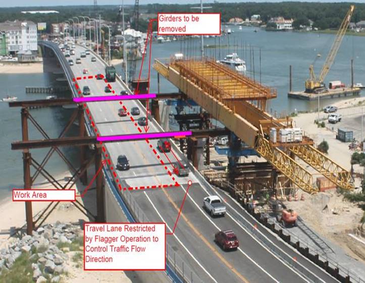
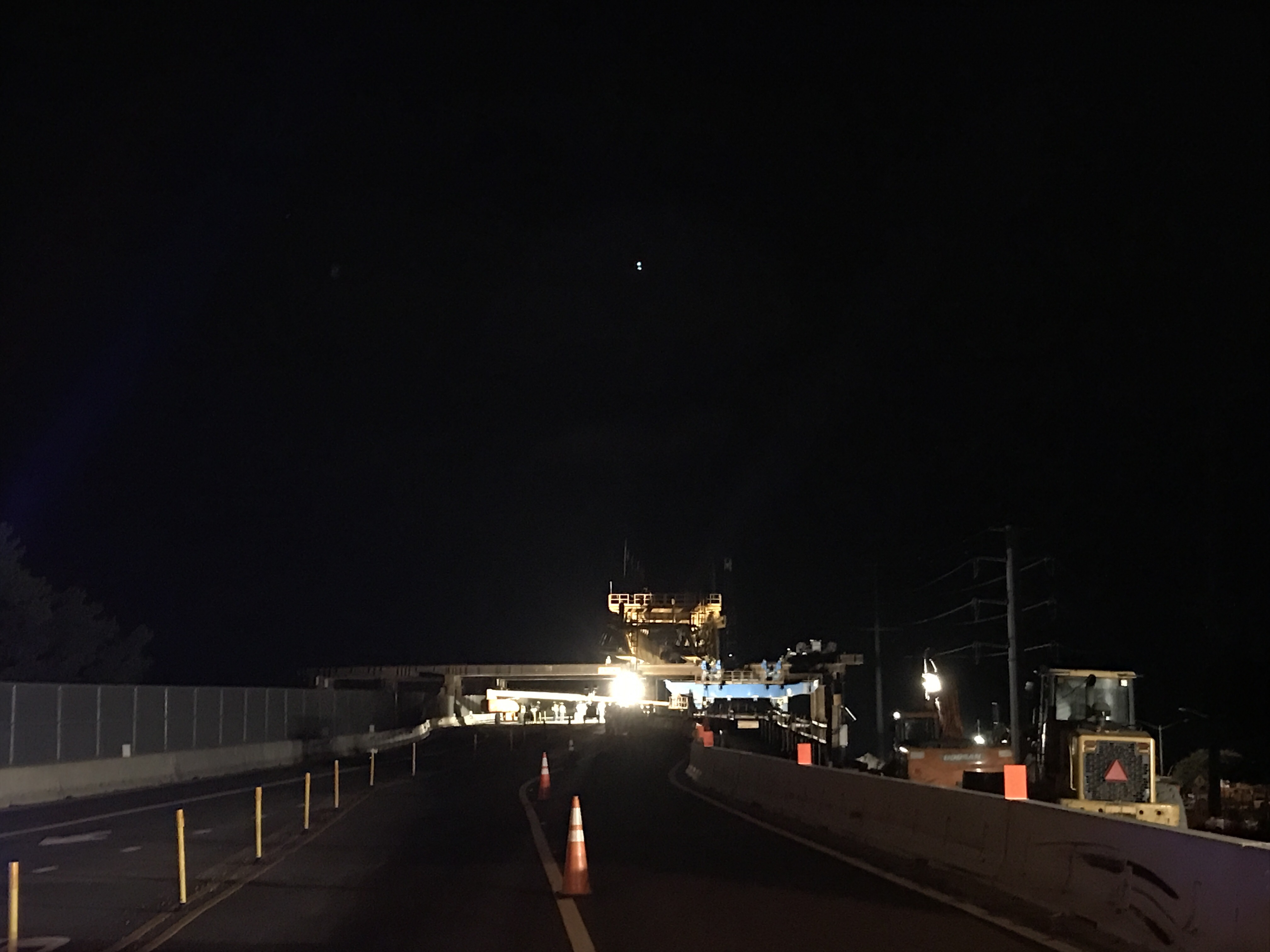
We have reached that point in the construction schedule where we need the gantry crane that is currently stored on the north side of Shore Drive to be put in place so that the superstructure of the new eastbound Lesner Bridge can be assembled.

To do this, we need to temporarily close Shore Drive to slide the gantry over the roadway and into position on the south side of Shore Drive.

This move will be conducted over three nights: June 19th, 20th, and 21st.

We will need short-term closures of Shore Drive between the hours of 12 midnight and 4 am, so as to disrupt as little traffic as possible. Note: One lane of the bridge will be kept open for use by emergency vehicles. In the event that emergency vehicles need to cross the bridge during this time, work will be temporarily halted to let the emergency vehicles cross the bridge. The detour route for all other vehicles during these dates and times is provided below.

Detour Route for the Temporary Short-Term Closure of Lesner Bridge

The move of the gantry crane will take place with the following anticipated schedule:

Monday, June 19th: 12 midnight through 4 am.

We will be:

    + Installing two support beams across Shore Drive to connect the falsework on the north side of the bridge to the falsework located on the south side
    + Connecting cables from the winches located on the south side of the bridge to the gantry located on the north side.
    + Re-opening Shore Drive to traffic.

NOTE: OVERHEAD CLEARANCE WILL BE 13’9” THEREFORE, OVERHEIGHT VEHICLES WILL HAVE TO USE ANOTHER ROUTE UNTIL THE SUPPORT BEAMS ARE REMOVED

Tuesday, June 20th: 12 midnight until 4 a.m.

We will be:

    + Completing preparations to the gantry rolling system and survey the falsework to ensure proper alignment of the channels.
    + Winching the gantry across Shore Drive and onto the falsework located on the south side of the bridge.
    + Re-opening Shore Drive to traffic.

NOTE: AGAIN . . . OVERHEAD CLEARANCE WILL BE 13’9” THEREFORE, OVERHEIGHT VEHICLES WILL HAVE TO USE ANOTHER ROUTE UNTIL THE SUPPORT BEAMS ARE REMOVED.

Wednesday, June 21st: 12 midnight until 4 a.m.

We will be:

    + Removing the two support beams from the falsework that crosses Shore Drive.
    + Re-opening Shore Drive to traffic.

NOTE: NO RESTRICTIONS TO OVERHEIGHT VEHICLES.

Gantry Support Falsework
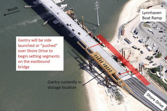
Gantry Move

Other Bridge Construction News:

In addition to the preparations being made for the gantry move, substructure work on the new bridge continues.
Piers 1 and 2 (of 9) of the new eastbound bridge have been completed. All of the drilled shaft foundations and the footing for Pier 3 have been completed and only one drilled shaft remains to be installed for the foundation at Pier 4.

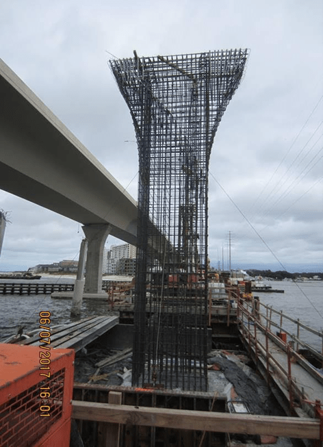
Reinforcing Steel at Pier Column 3

As McLean continues to build the new bridge substructure from the west, they are also continuing the demolition of the old bridges to the east and have completed approximately 80% of this demolition.

Bridge Demolition on the East side of Lynnhaven Inlet

AMI, Inc. in Portsmouth, continues to build the superstructure of the new Lesner Bridge. A total of 143 of the 168 segments have been cast for the new eastbound bridge. It is expected that all bridge segments for the eastbound bridge will be cast by August 2017.
Over the next two weeks, the bridge contractor will:

    + Continue bridge demolition;
    + Place concrete and complete construction of Pier #3;
    + Place reinforcing steel and concrete in the footing for Pier #4;
    + Install the falsework and seal slab for Pier #5;
    + Install the falsework and seal slab for Pier #6:
    + Place the leveling pad for the new MSE wall along the south side of Shore Drive between East Stratford Street and the new bridge;
    + Continue filling and grading operations at the new bridge abutments;
    + Install the new traffic signal pole and mast arm on the southeast corner of Shore Drive and East Stratford Street (to be done during the night of the Shore Drive Road closure on June 19th – 20th).

Other information regarding the status of the bridge construction can also be found at http://www.vbgov.com\lesner-bridge

As always, please contact us with any questions or concerns regarding this project and we will get back to you as soon as we can.

Drive Safely!
-Chris

Christopher J. Wojtowicz, PE
Project Manager
City of Virginia Beach
Department of Public Works
Engineering Division
2405 Courthouse Drive
Virginia Beach, VA 23456-9031
Office: (757) 385-5785
Fax: (757) 385-5668
Email: cwojtowi@vbgov.com

June Bayline from Bayfront Advisory Committee

View 5 page PDF.

. . .
STAFF REPORTS & UPDATES — Mark Shea, Tobias Eisenlohr
COMMITTEE REPORTS & UPDATES
Public Safety, Transit, Parking & Pedestrian Access- Charles Malbon Design Review – Joseph Bovee
Communications – Scott Ayers
PRESENTATION
Mermaid Winery Conditional Use Permit
. . .

4pm meeting at Brock about proposed parking lot CANCELLED

Previously at SDCC.info.

We will keep you informed when we know more.

Thank you for your continued efforts.

Inaugural Route 35 ride !

CLICK FOR 1 PAGE PDF OF ROUTE 35


Route 35 Firsts

First driver: John
First rider: Todd
First rider with a bike: Wally
First round-tripper: Tim

Roundtrip on this Inaugural run started about 905 to 1020am return trip at Vista Circle.

Ride 35.


Bayfront Shuttle that’s starting SUNDAY 830am VISTA CIRCLE

Woo hoo!

You’ll be able to travel from Shore Drive area to the Oceanfront and back without having to drive.

Or it Starts
SUNDAY VISTA CIRCLE 800am!

(Editor note: Brand new service with kinks the first day no doubt.)

Google Map to Bayfront Shuttle Route 35 stop at Vista Circle.

There’s about a 45 minute wait between buses.

Please be patient expect a learning curve for timely, consistent service.

This test year has Shuttle starting at Vista Circle.

Info at GOHRT.com:

Route 35. Starting May 21, ride the VB Wave from the Virginia Beach Oceanfront to First Landing State Park, the North End beaches, and all the wonderful Bayfront restaurants on Shore Drive. From May 22 through Labor Day, VB Wave shuttles will run every 45 minutes from 8:00 a.m. to Midnight every day. Then from September 8 through October 1, VB Wave shuttle service will run from 8:00 a.m. to Midnight, but only on Friday, Saturday, and Sunday.

Survey we ran back in summer of 2015.

Article at Pilotlone.com.

Thanks so far to everyone who has worked on this!!

“The old Lesner Bridge is getting a second life.”

From Pilotonline.com:

Although the state is paying McLean Contracting to rebuild the bridge, the contractor is using its own money to hire crews that move tons of concrete to the reef. The VMRC monitors the process.

Crews load up a barge of concrete pieces roughly every two weeks and travel about 18 miles to Cabbage Patch Reef. They begin the ride at midnight and make it by the time the sun rises.

Screen Shot of Construction Cam photo taken February 18th at noon.

#LESNERBRIGE

You, the community, are invited to a meeting Tuesday May 23rd at 4pm at Brock re: parking lot idea ON PHP.

Statement from Parks & Rec printed with permission:

“Parks and Rec has requested to have a tree inventory and survey completed of the construction entrance/parking lot area so amore environmentally sensitive parking area can be designed to accommodate 2 to 3 ADA compliant parking spaces and provide adequate space for a couple of vehicles to temporarily park to off load equipment then pull out onto the on street parking.

This parking area will be constructed at the end of the wetlands restoration project and utilize some of the area used for the construction ingress/egress into the wetlands project area.

The tree survey and inventory will also provide information needed for tree protection measures that will need to be put in place prior to and maintained during the wetlands mitigation project.”

Links to various info about Pleasure House Point on this website located here.

History of preservation of PHP back to 2003 is located on this website.

Brief highlights of the community’s involvement with preservation of Pleasure House Point 2001 – 2012:

  • Approximately $150,000 – $200,000 worth of consulting time was donated to efforts.
  • Those efforts resulted in the most recent real estate speculator to receive exactly 0 required permits.
  • The enforcement of the applicable laws & regulations governing wetlands, buffer, zoning etc reduced the perceived value of PHP & allowed the partners to purchase her for approximately $16.6M discount.
  • From VBGov.com/PHP:

    This high-profile property was once being considered for a large waterfront development, but with the help of The Trust for Public Land, the Chesapeake Bay Foundation and the surrounding community, the City has preserved one of the largest undeveloped parcels of land on the Lynnhaven River for generations to come.

    The community has been a vital part of Pleasure House Point for years and looks forward to continued participation with all the stakeholders going forward.

    About community engagement at this website from July ’14.

    correct link: https://weloveshoredrive.com/2014/07/24/the-pleasure-house-point-natural-area-represents-a-unique-opportunity-to-showcase-the-beauty-and-function-of-a-coastal-eco-system-in-the-midst-of-the-highly-developed-waterfront-community-in-the-bay/

    It’s official: “Item 6, Maurice M. Newton & et al – Shore Drive/Woodlawn Ave – GPIN 14891888970000 – Bayside, will be withdrawn at the May 22, 2017 Chesapeake Bay Preservation Area (CBPA) Board Public Hearing.”

    Per email from Mr PJ Scully, PLA for COVB CBPA.