“There’s a revolution happening,” said Chris Ludford, owner of Ludford Brothers Oyster Co., a boutique oyster grower in Virginia Beach. “In the last four to five years we’ve regained a foothold in a younger population of oyster eaters.”
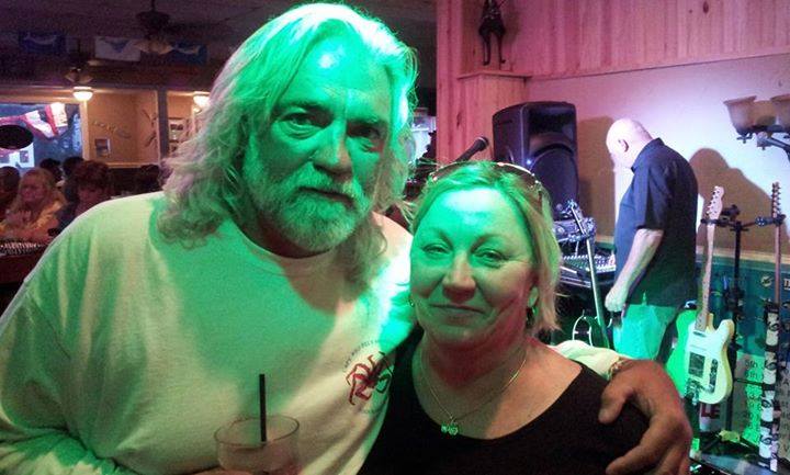
Alfonso Joseph Strazzullo, 88, of Virginia Beach, VA, passed away Monday, September 1, 2014

Al was an inspiring friend who you could always count on. Those who had the good fortune to know him knew he acted much younger than his age and was always interested in learning something knew and if he could help fix something, anything, he was your man. His sense of humor was infectious.
Al’s energy, enthusiasm and love for the Shore Drive community was unlimited.
He played critical roles in preserving Pleasure House Point, helping Shore Drive become safer for pedestrians, cyclists – everyone, by getting our speed limit to the appropriate level and helping us get the infrastructure projects in place that you see happening right now and for years to come, ensuring the City Marina stayed a Public Marina and much more.
Reviewing Our Work page – he was always involved whether it was creating and sharing his edgy cartoons to inspire others, to contacting anyone in power that could help improve the Shore Drive community, writing to whomever could make a difference, to presenting powerful presentations at public hearings – Al was there.
Thank you for making our world a better place.
Our condolences to Al’s family and friends.
The family will receive friends on Sunday, Sept. 7, 2014, from 6 to 7 p.m. at Hollomon-Brown Funeral Home, 1264 Great Neck Road, Virginia Beach.
Love traffic in Hampton Roads? Yea. Check out Hampton Roads Transportation Planning Organization’s Survey

Start here to view the Congestion Management Process Survey and related Draft Report.
The HRPDC provides staffing for the HRTPO to assist them in carrying out their responsibilities and to coordinate efforts with the Transportation District Commission of Hampton Roads, Williamsburg Area Transit Authority (WATA), and VDOT. The HRTPO’s Technical Advisory Committee provides review and recommendations on all regional transportation planning efforts.
“It’s the best-kept secret in Virginia Beach,” his wife chimes in.
Some guy from a show called the Deadliest Catch was in Froggies – Ocean Park – over Labor Day weekend
Read article entitled At day’s end, nightlife begins along Chesapeake Bay at Pilotonline.com.
“The small piece of plastic that likely contributed to the death of the whale in the Elizabeth River last week was part of a DVD case, a spokeswoman for the Virginia Aquarium and Marine Science Center said.”
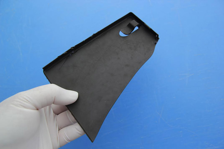
This sharp piece of plastic was found in a stomach chamber during a necropsy of the 45-foot long female sei whale that died in the Elizabeth River last week. (Courtesy of the Virginia Aquarium and Marine Science Center)
A whale.
Please, please, please never ever litter AND choose to pick up litter particularly plastic where ever you see it.
“Mrs. Brown – elegant, thin and warm with wispy white curls – takes line-dancing lessons twice a week. She sails and regularly swims in the bay, and is active with the Shore Drive Community Coalition and Lynnhaven River Now, an environmental nonprofit.”
The series continues at Pilotlonline.com:
And what better backdrop for their final act than the Chesapeake Bay, Mrs. Brown asks.
They have front-row seats for the drama of hurricanes, the action of windsurfing and the comedy of playful dolphins.
“We love the bay,” Mrs. Brown says. “There’s always something going on.”
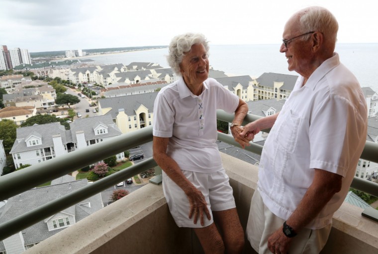
Westminster Canterbury residents Penny and Ty Brown relax after playing in a croquet tournament Saturday morning, August 23, 2014. (Martin Smith-Rodden | The Virginian-Pilot)
Weekly #LESNERBRIDGE update from Public Works Manager
*** As a reminder, the sidewalk on westbound Shore Drive is closed to pedestrians and cyclists between Page Avenue and East Stratford Street. If pedestrians need to cross the bridge, they will need to cross the eastbound bridge where we have provided a temporary 4-foot wide pedestrian/cyclist access.
Read entire update from an email:
Folks:
Below is the latest update for the Lesner Bridge Project from Chris Wojtowicz, project manager. Please let either Chris or me know if you have any questions or need additional information.
Also as an FYI – Public Works has created a project website at http://www.vbgov.com/lesner-bridge. We have posted information, background information, and – sometime within the next few days – a Twitter feed. A Construction Camera has also been installed to view images of the bridge construction, with images updated every 30 minutes.
Please visit this website for the current project updates and other useful project information.
Enjoy these last days of summer, and thanks for your interest.
Drew Lankford
Media and Communications
Department of Public Works
City of Virginia Beachdlankfor@vbgov.com
(O) 757.385.8062
(C) 757.409.4353Friends:
As many of you have seen, traffic patterns on Shore Drive are beginning to change as you approach the Lesner Bridge. Work over the next two weeks will consist of preparing both the eastbound and westbound bridge approaches for the lane shifts as we move into Stage 2 construction of the bridge.
The eastbound lanes on Shore Drive as you approach the bridge have already been shifted to the south. Work was done on Wednesday to place asphalt, temporary pavement markings, and delineators on Shore Drive between the bridge and East Stratford Street in preparation of the lane shift of the westbound Shore Drive traffic towards the sushi restaurant and away from 3556 On the Bay Condominiums. This traffic move will provide the required space we need to install the utilities, temporary retaining walls, grading, and infrastructure required for the new westbound bridge abutment.
A similar lane shift will also occur on the east side of the bridge towards the Lesner Inn. It will be several weeks, however, before we begin this lane shift. Once the contractor sets a date for this work, we will post another project update to inform you of the necessary details.
*** As a reminder, the sidewalk on westbound Shore Drive is closed to pedestrians and cyclists between Page Avenue and East Stratford Street. If pedestrians need to cross the bridge, they will need to cross the eastbound bridge where we have provided a temporary 4-foot wide pedestrian/cyclist access.
As Drew has mentioned, please visit our website for information and updates.
Thanks for your interest, and as always – Please Drive Safely!
-Chris
Christopher J. Wojtowicz, P.E.
Project Manager
City of Virginia Beach
Department of Public Works
Municipal Center-Bldg 2
2405 Court House Drive
Virginia Beach, VA 23456-9031
Phone: (757) 385-5785
Fax: (757) 385-5668
email: cwojtowi@vbgov.com

Screen grab at time of this post
SDCC General Meeting – Monday Aug. 25th at 7:30pm
Click here for a printable version of the agenda
MONDAY 25 AUG 2014
Shore Drive Community Coalition General Meeting
MONDAY 25 AUG 2014
7:30-8:30 pm
Ocean Park Volunteer Rescue Squad Station
(Intersection of Shore Drive and East Stratford Rd.)
Call to order
Meeting topic
- Discussion of Current City Issues
- POST-HURRICANE RECOVERY for NEIGHBORHOODS
Officers’ Reports: President’s Report David Williams
Vice President’s report Rick Mercadante
Secretary’s Report Todd Solomon –JULY Minutes
Treasurer’s Report Paulette Hruska
Old Business
New Business
Adjourn
Next SDCC- Monday SEP 29, 2014
Ocean Park Volunteer Rescue Squad Center
Please check www.sdcc.info for more information on area news and events
Bayfront Advisory Committee (BAC) Meeting (Thursday Aug. 21st) and Newsletter
Bayfront Advisory Committee to Meet August 21, 2014
The Bayfront Advisory Committee will meet Thursday, August 21, 2014,
at the Resort and Conference Center, 2800 Shore Drive, from 3:30pm-5:30pm
Click here for the meeting agenda and to read the latest BAC Newsletter
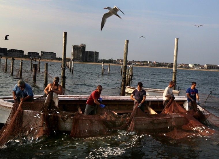
Bay provides means of livelihood for fishermen
This is the third of seven weekly narratives by Virginian-Pilot reporter Kathy Adams highlighting the beauty, the vibrancy and the struggles of the city’s Chesapeake Bay and Shore Drive communities.
Click here to read the article – http://hamptonroads.com/2014/08/bay-provides-means-livelihood-fishermen
Friends of Live Oaks (FOLO) Monday, Aug. 25th at 3:30 pm at Bayside Recreation Center
Minutes from last FOLO meeting:
Minutes – Friends of Live Oaks Meeting – Monday, July 21st, 2014 3:30
Penny has purchased the friendsofliveoaks.org domain name and has a contract for hosting our website. She will order business cards.
Penny has learned that the Beautification Committee of the North End Civic League plans to plant 4 live oaks along with other perennials in the median of Atlantic Ave. from 42nd to 89th Streets for a total of 118 trees.
Karen announced that 2 live oaks are being removed from a home on Lynnhaven Drive, and the owner would like us to find new homes for them. The owners will help transplant them.
We have registered to participate in the Lynnhaven River NOW Fall Festival on Oct. 11th at Rosemont Elementary School in Green Run.
Clay will talk with personnel from Little Creek to consider planting live oaks along Shore Drive.
Clay also discussed a grove of live oaks on Princess Anne Road adjacent to the Sportsplex. He suggested the possibility of partnering with Parks and Rec to preserve the grove, perhaps as a memorial garden. Also, Parks and Rec is developing a program to enhance Bayfront dunes and the area immediately behind them, promoting a maritime forest environment. This may be an opportunity to plant live oaks.2014 Live Oak Distribution –
This year’s distribution will be on Sat. Oct. 18th from 10am – 1 pm at Laskin Road Annex (the former Linkhorn Elementary School). Stephen suggested we give away 250 trees. People who request trees online will have preference; the remaining trees will be available on a first come/first service basis.The tree request form will include “4th Annual Live Oak Distribution”. It will also say something like: “We are reserving a tree for you and submission of this form confirms that you will pick up your tree on Oct. 18th.” It will only be available online this year, but there will be instructions for those who want to print the form and return it by snail mail.
Clay will work with the city to generate a press release, which will go to many outlets, including the Council of Civic Organizations.
The next meeting will be on Monday, Aug. 25th at 3:30 pm at Bayside Recreation Center.
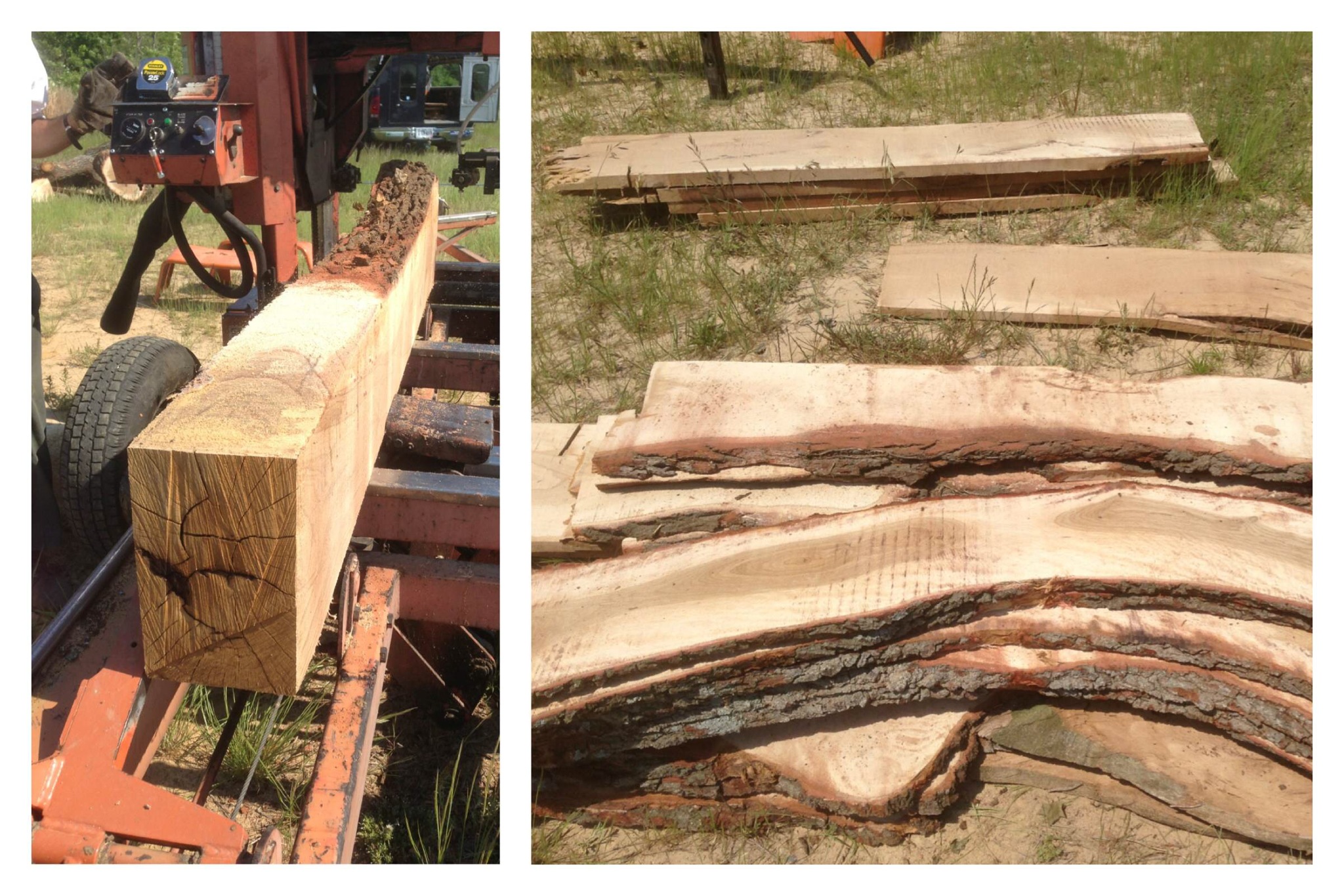
Rescued Live Oak wood being milled for CBF’s Brock Center.
#LESNERBRIDGE SIDEWALKS ARE CLOSED RIGHT NOW
We are trying to find out why and for how long.
We were told:
Nope. Just on the westbound bridge. You will have to use the eastbound bridge. They need to remove sections of sidewalk on the westbound bridge in order to build the new bridge abutment.
Pedestrians, Crosswalks and Frogger
I think many would agree that motor vehicle regulations have been put in place to address safety issues and to keep us safe. To be effective, these laws must be understood and applied fairly, not arbitrarily or capriciously. Given that broad statement, how should we drivers respond to pedestrians in crosswalks?
If you condense the VDOT Crosswalk statutes to their understandable part, what are we required to do when we come across a pedestrian and a crosswalk? VDOT laws can be found at http://www.virginiadot.org, specifically for crosswalks; 46.2-924 Drivers to stop for pedestrians.
If the speed limit on the road is 35 MPH or less, you are required to “yield the right of way to any pedestrian crossing…” Drivers entering, crossing, or turning at intersections shall change course, yield, slow down, or stop if necessary to permit pedestrians cross such intersections safely and expeditiously.
So, there you are driving down Pacific Ave down at the oceanfront and somebody steps into the crosswalk. You now slow down and some horn-happy driver behind you lets you know that apparently he is late for some important occasion. Or, even worse, that driver whips around you and then almost nails the pedestrian in the crosswalk. It is getting almost as dangerous for you to stop (getting rear-ended) as it is for the pedestrian if you don’t stop.
It seems like driver-pedestrian encounters are too commonplace and a lose-lose situation with mostly deadly consequences. People from other parts of the world where pedestrian crosswalk laws are rigidly enforced don’t know what applies. Some pedestrians become trapped in the no-man’s land, the center median as they seek temporary refuge. What gives?
How does the city and state (Dillon rules; state makes the laws, not the cities) solve this continuously dangerous situation? ENACT UNDERSTANDABLE LAWS, EDUCATE EVERYONE, and MOST IMPORTANTLY, ENFORCE. As for Frogger, it was a great video game in the mid-70’s where you, as a frog, tried to cross a busy road. This game should never be attempted in real life by us or our fellow drivers and pedestrians.
“The city of Virginia Beach has recently pulled this information to get an idea of where their citizens are cycling… Also clearly visible, is the use of Shore Drive.”
Learn more about the Bikeways & Trails Advisory Committee at VBGov.com.

Strava Labs is where Strava engineering occasionally releases side projects independent of our product.
Projects may be added, removed, or break at any time, so use them at your own risk.
“Last year, police recorded just two crashes on Shore Drive involving a bike and a car. There were 110 citywide, but only those with injuries or property damage are counted.”
Read part 2 of 7 at Pilotonline.com:
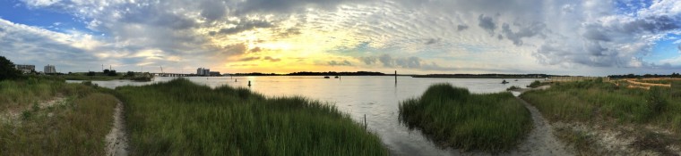
LIFE ALONG THE BAY
This is the second of seven weekly narratives highlighting the beauty, the vibrancy and the struggles of the city’s Chesapeake Bay and Shore Drive communities.
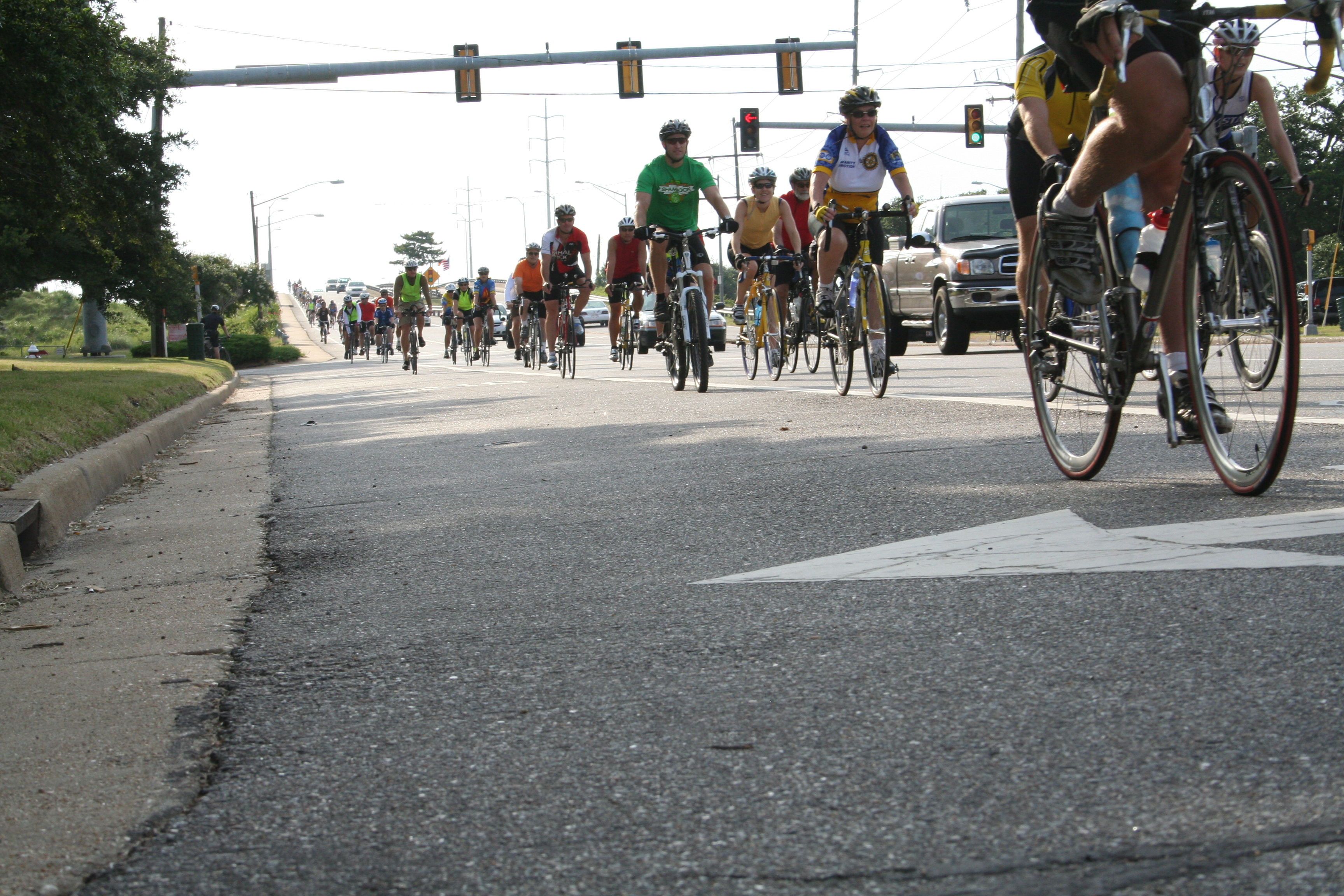
Photo Credit: Share Shore Drive Day July 11 2009
Miami and Virginia Beach are “are the top two areas of the country most at risk for residential…”
Miami and Virginia Beach are “are the top two areas of the country most at risk for residential…”.
Numbers like $39 billion do not seem to connect with most people in Virginia Beach, myself included. But, I can envision what a CAT2-3 hurricane could do to our community and my house. The thought of such losses can be daunting, but consider what you can do to limit the potential loss. And, that is what we are attempting to do at SDCC. We can’t give you a complete cure all package, but we can at least work to inform you how to limit the damages. We won’t pack your “go kit” for you, but we will tell you what you will need in it.
“Life Along the Bay”, Virginian-Pilot Series of Articles to focus on Bay and Shore Drive Communities
Check out the first of a seven article series entitled “Life along the bay” by the Virginian-Pilot
The articles will be weekly narratives highlighting the beauty, the vibrancy and the struggles of the city’s Chesapeake Bay and Shore Drive communities.
The first article “Along river, nature is preserved for wildlife, people” by Kathy Adams can be found here http://hamptonroads.com/2014/07/along-river-nature-preserved-wildlife-people
Friends of First Landing State Park receive grant from Dominion Power
Friends of First Landing State Park received a $10,000 Grant.
View Press Release at Dominion Power website.
Read list of Grant Recipients.
Check article at Pilotonline.com:
Friends of First Landing State Park in Virginia Beach will create an exploration lab to teach visitors about the health of the Chesapeake Bay.
About Friends of First Landing State Park:
FRIENDS OF FIRST LANDING STATE PARK is a non-profit 501c3 group that advocates in the community on behalf of First Landing State Park. Members participate in a variety of ways—advocacy, fundraising, and volunteering. Our mission is to support the park and outdoor stewardship in the community.

Oyster Reef Keepers of Virginia based in Ocean Park received a grant for Oyster Reef Restoration for $20,000.
#LESNERBRIDGE update from Public Works Project Manager
Over the next four weeks roadway work and preparations for the traffic lane shifts on Shore Drive will continue. Once this …
Read entire update from an email:
Below is the latest project update from Chris Wojtowicz, project manager for the Lesner Bridge project. We will be posting a Lesner Bridge Project page on our web site within the next few days so you can get updated information and pass questions and concerns along to us. Please feel free to use this e-mail address to do the same.
Please let me know if you have any questions or need additional information.
Many thanks.
Drew Lankford
Media and Communications
Department of Public Works
City of Virginia Beach
dlankfor@vbgov.com
(O) 757.385.8062
(C) 757.409.4353With July nearly behind us, the project team is wanted to provide an update on the Lesner Bridge construction.
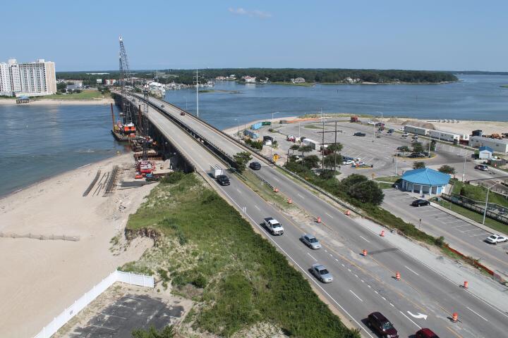
First of all, as many of you are aware, the residents of 3556 on the Bay condominiums have graciously allowed us to install a time-lapse camera on top of their building to photo-document the Lesner Bridge construction. This camera snaps a photo every 30 minutes and saves the images for use in a time-lapse movie. The link to this camera can be found at: http://rshcs.workzonecam.com/rshcs
Now for some important construction related information.
Due to the daytime lane closure restrictions on Shore Drive for the summer season, any work performed on Shore Drive requiring lane closures between now and October 1st will have to be performed at night. Beginning tonight at 9:00 PM and ending this Thursday work on Shore Drive between East Stratford Street and the western bridge abutment will require temporary lane closures.
This nighttime roadway work will include:
Tuesday, July 29, 2014 22:00-05:00 – Sawcutting edge of pavement on EB Shore Drive, outside lane
Wednesday, July 30, 2014 22:00-05:00 – Grading of shoulder area on EB Shore Drive
Thursday, July 31, 2014 22:00-05:00 – Paving median between EB and WB lanes on Shore Drive
The daytime work now taking place includes:
1) Installing oil/water separator structure, SW corner of Shore Drive and Vista Circle
2) Preparing area for drilled shaft construction at bridge Pier #1, NW side of Lesner Bridge
3) Preparing shoulder areas on EB Shore Drive between East Stratford Street and Vista Circle for pavement widening and temporary pedestrian access.
Over the next four weeks roadway work and preparations for the traffic lane shifts on Shore Drive will continue. Once this temporary roadway work is completed, eastbound Shore Drive traffic will be shifted south at both bridge approaches to make room for the shifted westbound lanes. Both lanes of the WB Shore Drive traffic between Page Avenue and the eastern bridge abutment and also between East Stratford Street and the western bridge abutment, will be shifted through the existing median onto what are now the EB lanes. This temporary Stage 2 traffic pattern will provide the room necessary for building the new WB bridge.
The Stage 2 traffic pattern for WB Shore Drive traffic will be as follows:
Between the existing Lesner Bridge and Page Avenue: Once WB Shore Drive traffic travels through the signalized intersection of Page Avenue and Shore Drive, traffic will be shifted south through the existing median onto what are now the EB lanes (both EB lanes will be shifted south towards the Lesner Inn and Bubba’s onto temporary pavement). These WB lanes will then be shifted back through the median and onto the existing WB Lesner Bridge approximately 250 feet before the bridge. WB traffic will then continue across the WB bridge.
Between the existing Lesner Bridge and East Stratford Street: After crossing the bridge, the WB traffic will be shifted again through the existing median onto what are now the EB Shore Drive travel lanes between East Stratford Street and the bridge. After approximately 300 feet, the WB traffic will be brought back through the median and back onto existing WB Shore Drive to the traffic signal at the Shore Drive/East Stratford Street intersection. WB Shore Drive traffic will then continue through this intersection just as it does today.
Please note that although the traffic lanes on Shore Drive are being shifted, the current lane designations will be maintained. The LEFT TURN lanes on Shore Drive at East Stratford Street and Page Avenue will be re-marked and maintained throughout the Stage 2 traffic pattern.
This is a lot of information, so if you have any questions or concerns about the ongoing or upcoming work, please contact me at the number or email address below and I will do my best to answer whatever project question you may have.
Drive Safely!
-Chris
Christopher J. Wojtowicz, P.E.
Project Manager
City of Virginia Beach
Department of Public Works
Municipal Center-Bldg 2
2405 Court House Drive
Virginia Beach, VA 23456-9031
Phone: (757) 385-5785
Fax: (757) 385-5668
email: cwojtowi@vbgov.com
“The Pleasure House Point Natural Area represents a unique opportunity to showcase the beauty and function of a coastal eco-system in the midst of the highly developed waterfront community in the Bayfront area of Virginia Beach. The property has been manipulated time and time again over the past 50 years. Even with all of this intrusion, the environment has survived and flourished as a prime example of the resilience of a natural eco-system.”
View 88 page PDF online at VBGov.com.
About the Management Plan
This management plan was developed to comply with the conditions of the recorded conservation easement. The recommendations that are contained within the management plan are the result of a year long study of the property. This plan has a horizon of five years. It will be important to measure the progress made annually on the stated goals in the plan and to update the plan every five years.
The Pleasure House Point Natural Area represents a unique opportunity to showcase the beauty and function of a coastal eco-system in the midst of the highly developed waterfront community in the Bayfront area of Virginia Beach. The property has been manipulated time and time again over the past 50 years. Even with all of this intrusion, the environment has survived and flourished as a prime example of the resilience of a natural eco-system. There are many lessons to be learned from this property, as well as many actions we can take to restore and enhance the property. This document was developed with this charge in mind and outlines specific steps and priority projects to ensure that the property is properly managed and maintained for the benefit of both man and nature.
About Management Objectives
The conservation easement is held by the Virginia Department of Game & Inland Fisheries (VDGIF). This management plan is being developed to comply with the conditions of the recorded conservation easement and the management plan has been coordinated with VDGIF. The management plan will govern operations and maintenance as well as future improvements and restoration projects on the 84.658 acre parcel known as the Conservation Easement Parcel. The site must be managed consistent with conservation goals used to rank and fund the project as listed below.
• Maintain habitat values
• Maintain Coastal Maritime Forests
• Maintain water quality
• Maintain/educational and recreational values not detrimental to other aspects
About Public Engagement
There will be many different opportunities to provide environmental education in partnership with Chesapeake Bay Foundation and Lynnhaven River Now. In addition, the City will be providing outdoor programming in the park. We will continue to keep the neighbors engaged by coordinating regularly with the Bayfront Advisory Committee, the Shore Drive Community Coalition and the Ocean Park Civic League. The Bayfront Advisory Committee is appointed by City Council and provides a forum for residents and businesses in the area to discuss land use, transportation and social issues. The Shore Drive Community Coalition is a volunteer organization that coordinates among various civic groups. The Ocean Park Civic League represents the neighborhood directly adjacent to the site and the members have officially adopted the Pleasure House Point Natural Area and are responsible for conducting at least one trash clean up quarterly on the property. They are also diligent in reporting violations of the pet waste and leash laws.
I encourage you to read and digest the entire document.
It’s fascinating.

