To Fans and Keen Observers of the Lesner Bridge Project:
“Spring has sprung, the grass has risen, the project continues, and I like bacon”
My literary and poetic skills aside . . . the slow departure of winter and emergence of warmer, spring weather has inspired our Bridge Guru, the honorable Chris Wojtowicz – to come forth with a Lesner Bridge Project Update – just as the groundhog predicted.
Work is proceeding fast and furiously, with crews taking advantage of the warmer temps to get as much done as possible. Just so you’ll have a more in-depth analysis, Chris explains all the latest details below.
As always, please feel free to let Chris or me know if you have any questions or need more information. If you haven’t had the opportunity to watch this construction sequence animation, please check it out: https://www.youtube.com/watch?v=fVkeFJWm85s&feature=youtu.be
As a reminder, we are regularly updating information on our WEB page at: http://www.vbgov.com/lesner-bridge. You can also follow us on Twitter at: @lesnerbridge.
If you know of someone who would like to be added to our update list, please have them get in touch with me at this e-mail address and I will be glad to add them. Please feel free to pass this along to others.
Thanks again for all of your interest and patience throughout this project. Summer is just around the corner, so hang in there.
Drew Lankford
Media and Communications
Department of Public Works
City of Virginia Beach
dlankfor@vbgov.com
(O) 757.385.8062
(C) 757.409.4353
***********************************
To All:
“In like a Lion, out like a Lamb”, this March is certainly living up to that saying.
The Lesner Bridge project team loves the “Lamb” and the warmer weather that is beginning to work its way into Virginia Beach. It’s a welcome change to the cold, wet and windy February that we experienced.
Many of you have noticed something different about the bridge construction recently – only half of a bridge span was constructed before the gantry crane was moved and is now resting on what appears to an unsupported (floating) extension of the bridge superstructure. You can see this this step in the construction sequence animation at about 2:08 minutes in. Although this looks odd, we can assure you that the bridge has been designed specifically for this point in construction.
We are now working on Span 5 (of 10) on the new westbound Lesner Bridge. This particular span is 225 feet long and is the main center span of the bridge. All other spans of the bridge are 150 feet wide and can be built entirely beneath the gantry (span by span construction). Since the main span is greater than 150 feet, the gantry crane cannot use the span by span construction method and instead must use the cantilever method. The additional strength needed to support this cantilevered section of bridge is provided by additional internal tendons located inside the top deck of bridge spans 4, 5, and 6 as well as temporary external tendons located inside the box girders of spans 4, 5, and 6. The top deck tendons (cantilever tendons) are snaked through the main span segments, through the adjacent pier segments, and anchored into subsequent typical segments in span 4 (or span 6 if on the east side of the channel).
Internal Tendons (inside blue stressing jack) inside top deck of Span 5 of the new Westbound Lesner Bridge
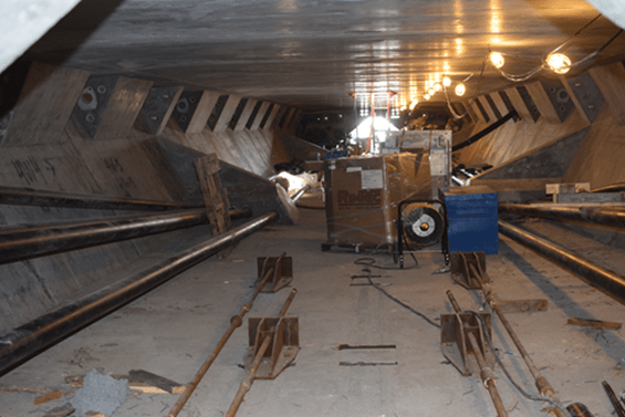
Internal Tendon Anchorages (top corner areas) inside Span4 of the new Westbound Lesner Bridge
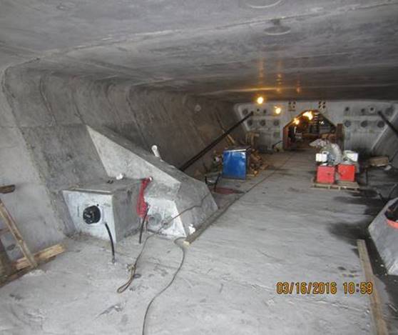
Temporary External Tendons (black pipe) inside Span 5 of the new Westbound Lesner Bridge
Span 5 will be built in two sections; 5A (west of channel and built from west to east) and 5B (east of channel and built from east to west). The construction of span 5A has been completed and the gantry is currently being readied for a launch over to the steel falsework located at pier #5 (east side of the channel).
The construction of span 5B gets a little tricky since we have to balance the construction loads at pier #5 in order to prevent damage and/or failure of this new pier column. To accomplish this, we are going to build span #6 (150 feet wide and located between piers #5 and #6) prior to completing span 5B. Once span #6 is anchored (via tendons) to the two piers, this span will serve as a counterweight to balance the load that span 5B will place on the column at pier #5. Therefore, over the next 5 weeks you will see the following work taking place on the bridge superstructure:
1) Both pier segments placed on top of pier column #5;
2) The steel falsework moved from pier #5 to pier #6;
3) The gantry launched from pier #5 to pier #6;
4) Both pier segments placed on top of pier column #6;
5) Typical segments for span #6 delivered by barge;
6) Gantry will lift typical segments from the barge and set them into place for span #6;
7) Gantry will backlaunch (from east to west) to span #5;
8) Span #5 bridge segments will be delivered by truck to the gantry and will be assembled in span 5B from east to west;
9) The main span closure (bridge center) will be cast in place and continuity tendons installed to join spans 5A and 5B.
10) Gantry will be launched to span #7
Yes, it’s complicated. With all these additional steps the work may seem like it’s slowing down but we can assure you that progress is being made on these critical path tasks.
Now, a brief summary of work that we have completed since the last project update (2/10/2016):
Ø Span 4 and 5A (of 10) of the new westbound Lesner Bridge has been completed;
Ø The falsework at pier #5 has been installed in preparation for the next gantry launch;
Ø The footing for pier 8 has been completed, thus completing all of the bridge footings for the westbound bridge;
Ø The construction of pier columns #7 and #8 have been completed;
Ø The steel reinforcing for pier column #9 has been tied and is being readied for concrete placement. This is the last pier column for the westbound bridge;
Ø We completed segment casting for spans 7 and most of 8;
Ø Both storm drain structures have been installed on the east side of East Stratford Street north of Shore Drive;
Ø The parapet wall and handrail anchor bolts have been installed on the MSE wall in front of 3556 On the Bay Condominiums and across spans 1,2, and 3;
Ø The permanent barrier wall along the south side of the new westbound Lesner Bridge has been installed up to span 3; and
Ø Approximately 300 feet of conduit and water main has been installed inside the new bridge.
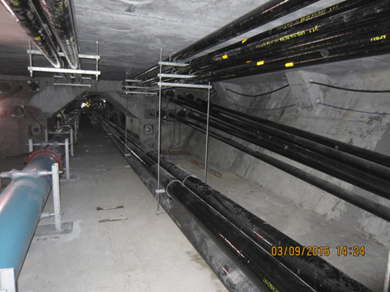
Water main, Power and Communications Conduit inside the new Westbound Lesner Bridge

Completed Bridge Spans 1, 2, 3, 4, and 5A Cantilever of the new Westbound Lesner Bridge
With the exception of pier column #9, the construction of all of the new westbound bridge substructure has been completed including all of the drilled shaft foundations and pier footings. As we have mentioned earlier, erection of the bridges superstructure continues with an expected bridge completion date in September 2016.
AMI, Inc. in Portsmouth, continues to build the superstructure of the new Lesner Bridge. A total of 134 of the 168 bridge segments have been cast for the new westbound bridge.
Over the next two weeks, the bridge contractor will:
Ø Launch the gantry to span #6 and set the pier segments on pier columns #5 and #6;
Ø Form and place the concrete in the column for Pier #9 (this is the last remaining column to be constructed for the westbound bridge);
Ø Install various utilities inside the completed sections of the westbound bridge
Ø Install the new storm drain pipe along the east side of East Stratford Street on the north side of Shore Drive.
That’s it for now. Please drive safely!
– Chris
Christopher J. Wojtowicz, PE
Project Manager
City of Virginia Beach
Department of Public Works
Engineering Division
2405 Courthouse Drive
Virginia Beach, VA 23456-9031
Office: (757) 385-5785
Fax: (757) 385-5668
Email: cwojtowi@vbgov.com