November 7th Tuesday at City Council, COVB Attorney Mark Stiles will make a presentation about Short Term Rentals.
View the DRAFT presentation. (28 page PDF)
November 7th Tuesday at City Council, COVB Attorney Mark Stiles will make a presentation about Short Term Rentals.
View the DRAFT presentation. (28 page PDF)
At the 30 OCT 2017 SDCC monthly meeting, the environmentally astute Tim Solanic said that saving the city’s Live Oaks should be “The Norm, not the exception”. Is that a voice in the city’s wilderness speaking out? Destroying a magnificent tree that has taken a century or more to grow to make way for a structure that probably will not last a hundred years seems to point out our short-sightedness at the expense of long term goals for our city. What do we want for our city and for our future generations? Think about what you want to show your great grand children and talk about. We should all want a remarkably durable city of quality with a deep sense of history.
David Williams
Special thanks to Frank Fentress & Susan French of COVB, Elisa Morrell, Michelle Zimmerman, Chesapeake Beach Civic League, Friends of Live Oaks and all those who support treating of our precious live oaks instead of destruction.
Here’s the update at the Change.org Petition set up for her.

Thanks to Cindy & Jennifer for a great presentation & discussion last night at our meeting about Envision Virginia Beach 2040!
Learn more about Envision Virginia Beach 2040 at VBGov.com.
How do you envision Shore Drive in 2040? Join us at their next meeting.
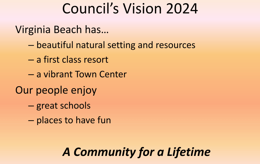
“In 2011, the Mayor appointed a 13-member citizen “visioning” group. They studied and analyzed current trends to understand the forces affecting our community. “Where are we now…where will we be… where do we want to be?” They answered those questions and crafted Virginia Beach 2040. The 2040 Vision to Action Community Coalition shares the pathway and the vision.”
The following link includes more info including a link to the Envision Virginia Beach 2040 Committee Final Report.
https://www.vbgov.com/government/departments/sga/pages/envision-virginia-beach-2040.aspx
Click here for a printable version of the agenda 10.30.17 SDCC Agenda
SDCC General Meeting Agenda
Monday October 30, 2017 from 7:30 to 9:00pm
Ocean Park Volunteer Rescue Squad Hall
(parking in back, on side streets and across Shore Drive)
Special Presentation – 2040 Vision to Action Community Coalition Commission, Ms.Cindy Arocho of the Commission will provide background and answer questions. In 2011, the Mayor appointed a 13-member citizen “visioning” group. They studied and analyzed current trends to understand the forces affecting our community. “Where are we now…where will we be… where do we want to be?” They answered those questions and crafted Virginia Beach 2040. The 2040 Vision to Action Community Coalition shares the pathway and the vision.
Officer’s Reports:
Secretary – David Williams
Treasurer’s Report -Kathy Pawlak
Vice President – Wally Damon
President – Todd Solomon
Old Business-
Bayfront Development Projects Update –
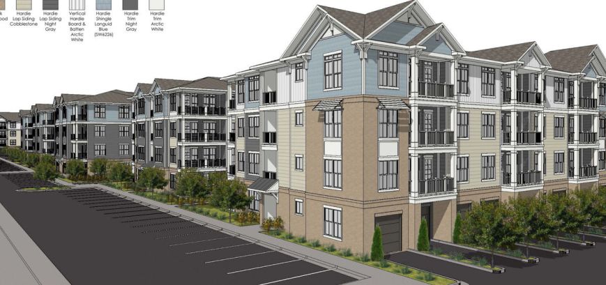
• Marina Shores Marina Apartments – Approved at Oct. 11th meeting of the Planning Commission.
• New Millennial Assisted Living Facility Expansion – SDCC letter being sent to City Planning and Traffic Engineers asking for the omission of the two new left turns based on the increase in traffic conflicts, low volume of left turns and access at two additional entrances.
New Business –
Bayfront Advisory Commission (BAC) News – Mr. Wally Damon will update us on the actions of the Bayfront Advisory Commission.
Addition of “Your Speed Is” Traffic Signs on Shore Drive – SDCC would like to make a motion to request the BAC to pursue the purchase and installation of these signs at key sections on Shore Drive. Norfolk has several of these signs operating on Shore Drive in Ocean View already.
VB proposed changes to Route 35 and other bus services – City Planning and Traffic Engineering have submitted a request to continue the service next year and to add a 3rd bus to allow shorter wait times. The service would also extend to Pleasure House Road. According to a Virginian Pilot article, the City Manager doesn’t feel additional funding of any mass transit in the City is worthwhile.
City Planners Losing Focus on Shore Drive Safety? – The addition of left turns where they’re not justified as part of the New Millennial development and the suggestion to add a crosswalk at North Great Neck Rd. and Lynnhaven Dr. intersection, seem to identify an unsafe trend in City Planning. Your thoughts and suggestions for action are welcomed.
Community Concerns– General discussion of neighborhood and community concerns that may need SDCC attention. This is an opportunity for all to share information.
Next SDCC Meeting – Monday November 27, 2017
No Special Presentation Planned
SDCC Elections are coming up. Please let an officer know of your interest.
View the article including photos at Pilotonline.com:
Planning Department Director Barry Frankenfield offered to look into adding a crosswalk at the intersection of Great Neck Road and Lynnhaven Drive for residents to walk safely to a shopping center across the street.
Click the image to head there.
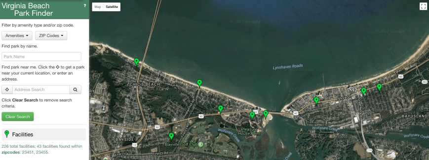
Screen shot of 23451 & 55 search.
Hurricanes Harvey, Irma, and Maria’s Lessons
At Least the BASICS!
As we watched Hurricanes Harvey strike the Houston area, Irma strike Florida, and then watched Maria devastate Puerto Rico, we witnessed the might of CAT4+ hurricanes upon structures and people. These massive storms again remind us of our need for personal and family disaster planning. Consider what we would do if one of these hurricanes had struck our area or city? One of these days, a severe storm will inflict destruction here in our city and area.
Harvey was a “rain event” hitting Houston with continuous monsoon rains for days. Irma led forecasters on a “storm chase”. Unable to accurately predict its track, made forecasting difficult to determine probable impact area and prepare until the last 48 hours.
Maria devastated Puerto Rico and destroyed the island’s obsolete and poorly maintained power grid. Winds and flooding destroyed 90%+ of the island’s homes, structures and transportation infrastructure. Half of the island’s 3 million residents are without clean water two weeks after the storm passed. Cholera and typhus outbreaks are possible.
All three hurricanes, dangerous, and deadly demonstrate that we should be prepared for AT LEAST THE BASICS. Our efforts should do what is required to get us through. For basic planning, see CASPER (Coastal Action Storm Plan and Emergency Response) and Strategic Recovery Plan on SDCC websites: (https://sdcc.info). Join your neighborhood civic organization. Check out the SDCC website.
Consider the following:
Planning. Do enough to get you and your family through the first week following a storm. Greatest needs are:
Weather Forecasting. Waiting for the forecaster’s “spaghetti” tracks to give enough warning may not leave you enough time to make preparations. Your family timeline should probably not be the same as shown by city and state officials. When state and city officials determine that the threat is eminent, it may be too late for you to react. You know your needs. It is safer for you to be cautious and follow your timeline.
Basic Necessities. Consider the necessities. Buy the basics. Don’t get fancy. Putting in a $9,000 emergency generator does no good if flooding destroys it. Consider your “real” necessities and do what will provide you, your family, and pets with the basics; food, water, and shelter, security and some level of comfort.
Communications. A text message sent from a loved one who has been in peril can ease a parent’s or spouse’s anxiety. With our smart phones and devices, sending a group text to family and friends can be easily accomplished if your phone has some power left even with a weak signal. Recharging devices can present a challenge, but is doable using your car’s outlet, with a solar charger, or connecting to a battery. We just need to have the required connectors.
Flood Insurance. As Hurricane Harvey moved very slowly through the Houston area, it became a “Rain event” causing extensive flood damages. Atypical monsoonal (1+ feet per hour) rainfalls flooded areas that had no history of past flooding. In these flood areas, only 15% had any kind of flood insurance. Flooding occurred when very heavy rainfalls surpassed city’s drainage systems capacities. Obviously, cities cannot afford to build drainage systems for 500-year flood levels. The destruction of a home that is not covered by flood insurance presents many issues, not only for the owner, but also for real estate assessments, city funding, and mortgage banking. Would it be cost efficient and reasonable to spend $2,000 to $5,000 per year for flood insurance for a once in a lifetime (?) event? Perhaps the insurance industry should offer coverage for a much lower risk flood event at a significant discount if more properties were covered? Until available, consider the “Rain event” flood possibility for your home, condo or apartment.
David Williams
CHSCA Emergency Planner
4 OCT 2017
“We have talked to each other back and forth informally for almost 20 years, but this year, we have put a deal together that we can both live with,” wrote Hoyt Duff, who is married to the woman whose father helped build the pier.
View October Baylines. (4 page PDF)
Baylines includes:
Vice Mayor Louise Jones,, Ocean Park Civic League President Andrew Broyles and Mayor Will Sessoms participate in a ceremony unveiling median signs on Shore Drive delineating the historical neighborhood…

According to the Virginian-Pilot article, which can be read by clicking this link,
A 10-hour standoff with an armed man in a car ended Monday morning when the man took his own life, police said.
The incident began just before midnight when a neighbor called police about a “dispute” on the 2300 block of West Great Neck Road, said Virginia Beach police spokeswoman Tonya Pierce.
The man, who was in his car alone, threatened to harm himself, she said.
Part of West Great Neck Road was closed during the standoff and residents in the area were notified of the situation through a reverse 911 call.
Swimming Advisory Lifted for Two Areas: Along the Bay from Little Creek to Fort Story and along the Oceanfront from 8th to 22nd Streets
The Virginia Beach Health Department has lifted the swimming and wading advisories that were issued yesterday, Wednesday, Sept. 20, along the Bay from Little Creek to Fort Story and along the Oceanfront from 8th to 22nd streets.
After re-sampling showed that the bacteria level in the water was once again safe for swimming and wading, the advisories were lifted and signs at both locations that had previously alerted the public of the advisory have now been removed.
Recreational waters are monitored for bacteria using indicator organisms such as enterococci, the indicator of choice for estuarine and marine waters. Enterococci are a group of organisms used to determine the extent of fecal contamination of recreational waters.
While enterococci do not cause illness, scientific studies indicate that their presence is closely correlated to the presence of other disease-causing organisms. People swimming or wading in waters with bacteria levels higher than the standard have an increased risk of developing gastrointestinal illness and skin, eye and respiratory infections.
Environmental health officials sample recreational beach water on a weekly basis during the swimming season from May through September.
For additional information, contact Brad Delashmutt, Virginia Beach Health Department, at (757) 518-2727.
Swimming Advisory Issued for Two Areas: Along the Bay from Little Creek to Fort Story and along the Oceanfront from 8th to 22nd Streets
The Virginia Beach Health Department has issued two swimming and wading advisories today for two sections:
• along the Bay from Little Creek to Fort Story and
• along the Oceanfront from 8th to 22nd streets.
Recreational waters are monitored for bacteria using indicator organisms such as enterococci, the indicator of choice for estuarine and marine waters. Enterococci are a group of organisms used to determine the extent of fecal contamination of recreational waters.
Signs will be posted on the beach between to alert the public of the swimming and wading advisory. The signs will read:
WARNING! SWIMMING ADVISORY
Bacteria levels do not meet state water quality standards
Swimming and wading are prohibited until further notice
Virginia Beach has conducted these tests since the mid-1970s. Health officials will continue testing the site until the water quality meets the state water quality standards. When the sampling test results meet the standards, the signs will be removed.
While Enterococci do not cause illness, scientific studies indicate that their presence is closely correlated to the presence of other disease-causing organisms. People swimming or wading in waters with bacteria levels higher than the standard have an increased risk of developing gastrointestinal illness and skin, eye and respiratory infections.
Environmental health officials sample recreational beach water on a weekly basis during the swimming season from May through September.
For additional information, contact Brad Delashmutt, Virginia Beach Health Department, at (757) 518-2727.
# # #
News Release: goo.gl/kYW6YL
For more news: VBgov.com/News
Click here for a printable version of the agenda.9.25.17 SDCC Agenda
SDCC General Meeting Agenda
Monday September 25, 2017 from 7:30 to 9:00pm
Ocean Park Volunteer Rescue Squad Hall
(parking in back, on side streets and across Shore Drive)
Special Presentation – None Planned
Officer’s Reports
Secretary – David Williams
Treasurer’s Report -Kathy Pawlak
Vice President – Wally Damon
President – Todd Solomon
Old Business-
Bayfront Development Projects Update –
• Marina Shores Marina Apartments – Deferred until the Oct. 11th meeting of the Planning Commission. Presentation made to Cape Story by the Sea Civic Association. Updates will be discussed.
• Bay Lake Assisted Living Facility Expansion – Approved by City Council with an 11-0 vote. One speaker voiced concerns over adding two new left turns that cross Shore Drive at the intersection of Indian Hill Road. City Traffic Engineers said the low traffic volumes and slow speed limit of 35mph won’t make extra conflict points a safety hazard.
• Resort Conference Hotel Proposal to Convert to Assisted Living Facility – No new details
• Mermaid Winery – Approved by City Council. Scheduled to open by the end of 2017.
VB proposed changes to Route 35 and other bus services – Bus route operation is now only Friday-Sunday until Labor Day. The City continues to make plans to run the route next summer with shorter wait times and improved service. Community support for increased budget of $100k for an extra bus may be required.
Pleasure House Wetland Mitigation Program – Project includes a wetlands mitigation bank for City projects, ADA access and parking lot for 5 vehicles and public water access. Planning is 60% complete and construction is set to start in December 2018. Ocean Park Civic League has taken lead on this and is working with the City to create a project that will work for the neighborhood.
New Business –
Bayfront Advisory Commission (BAC) News – Mr. Wally Damon will update us on the actions of the Bayfront Advisory Commission.
Baylake Pine Lower School Development – Planned office/business space at old school location at Treasure Island Dr and Shore Dr intersection. The developer will be speaking at a special Baylake Pines Civic League meeting on Tuesday Sept. 26th.
Beach Sand Replenishment Projects – A replenishment of Chesapeake Beach is scheduled for early 2018. The $4.8mil will widen the beach 100-150 feet. Continued replenishment is set for a 4-5 year cycle. Lynnhaven Inlet dredging with replenishment to Ocean Park and Cape Henry beaches is scheduled for Fall 2018.
Community Concerns– General discussion of neighborhood and community concerns that may need SDCC attention. This is an opportunity for all to share information.
Next SDCC Meeting – Monday October 30, 2017
Special Presentation – 2040 Vision to Action Community Coalition Commission
The group conducts public outreach, monitors and reports on the City’s progress for achieving the vision
Update from email:
Residents/Folks/Travelers/Bridge Gazers:
As the hot, steamy days of summer give away to the almost-as-hot days of a Hampton Roads autumn, we find ourselves exchanging the soft summer breezes for the brutal breezes that feel like needles painfully piercing your face and arms from the winds of the latest tropical storm. As you fuel your generator and horde lots of Chef Boy-Ar-Dee and peanut butter, you might want to stockpile some reading material. Why not start with this update?
Mr. Chris the Kingfish and his crews having been plugging away all summer on the popular Lesner Bridge project. Included in this update is chit chat about the gantry, the fender system, a cofferdam, and mechanically stabilized earth. (Some of us will be breaking into discussion groups once we have completed the reading, hoping to dig through some of that deep sub-text that comes with these engineering updates.)
As always, we appreciate your questions and e-mails, so please don’t hesitate to contact us. We are regularly updating information on our WEB page at: http://www.vbgov.com/lesner-bridge. You can also follow us on Twitter at: @lesnerbridge. If you haven’t already signed up for the City’s FB page or Twitter account, I encourage you to do so so that you receive timely updates from all things City-related.
If you know of someone who would like to be added to our update list, please have them get in touch with me at this e-mail address and I will be glad to add them. Please feel free to pass this along to others.
Thanks again for all of your interest and patience throughout this project. And don’t forget . . . stay safe, look out for each other, and put the phone down while you’re driving.
Drew Lankford
Media and Communications
Department of Public Works
City of Virginia Beach
dlankfor@vbgov.com
(O) 757.385.8062
(C) 757.409.4353***************************************
Folks:
We are in the peak of hurricane season, and with all of the talk and news coverage of the hurricanes churning in the Atlantic, it is worth noting that should a storm impact this area and winds begin to gust above 90 mph, it will be necessary to TEMPORARILY CLOSE the Lesner Bridge to all but emergency vehicles due to the proximity of the construction gantry. We kept a very close eye on the storm track of Hurricane Irma and were ready to take the necessary precautions to secure the Lesner Bridge construction site, if needed. Fortunately, that no longer seems to be a concern.
Even though storm preparations were being made, construction work on the bridge continued. Since the last project update in early August, two more spans of the new eastbound bridge have been completed (spans 2 and 3) and if the weather holds out, McLean Contracting could launch the gantry crane to bridge span #4 as early as this Friday the 15th.
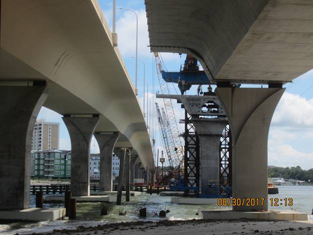
View Looking East from atop the Gantry (New Westbound Lesner Bridge shown on left)
New Westbound Lesner Bridge (left) and Completed Span #2 of the New Eastbound Lesner Bridge (right)
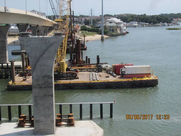
As work continues on the bridge superstructure, other work is also being completed concurrently. Folks that use the Lynnhaven Inlet will notice that the southern half of the new bridge fender system is now being constructed on either side of the main channel. Within the next few weeks all of the piles for the new fender system will be driven. The timber rails and walkways, as well as the permanent lighting for this fender system, will be installed through the month of October, and we anticipate completing it by the first week of November.
New Westbound Lesner Bridge (left) and Completed Span #2 of the New Eastbound Lesner Bridge (right)
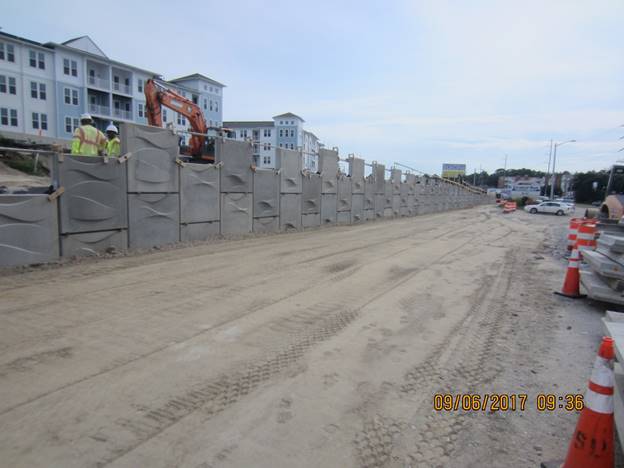
New MSE wall in front of Bubba’s Restaurant and the Lesner Inn
A lot of work is also occurring along Cape Henry Drive on the east side of the bridge in front of the Lesner Inn, and the Virginia and Maryland Pilots Association. At this location, work has begun on the last MSE (Mechanically Stabilized Earth) wall for the project. With a length of 645 feet, it is also the longest MSE wall on the project and is expected to be completed by the first week of October.
Installation of drilled shaft foundations for the bridge pier columns also continues. All but one of the drilled shafts have been installed for Pier #5 and at Pier #6 only one drilled shaft remains to be placed. McLean will mobilize the drilling equipment to Pier #7 at the completion of these two drilled shafts. Preparations for work at Pier #7 have already been made. The cofferdam at Pier #7 has been installed, and the permanent steel casings for the 5 drilled shafts at this location have been delivered to the work area.
In summary, the following work has been completed since our last project update in August:
· Most of the old Lesner Bridges have been demolished, with only a few in-water concrete piles remaining to be removed;
· Spans 1, 2, and 3 (of 10) for the new EB bridge have been completed and the gantry crane is being prepared for launching to Span #4;
· The footing and column at Pier #4 have been completed;
· Streetlight pole foundations on the new eastbound bridge approach between East Stratford Street and the new bridge have been installed;
· 9 of the 10 drilled shafts for Pier #5 have been installed;
· 4 of the 5 drilled shafts for Pier #6 have been installed;
· Work on the southern half of the new bridge fender system has begun;
· 9 of the 10 drilled shafts for Pier #5 have been installed;
· Approximately 400 linear feet (of 645 linear feet) of MSE Wall #5 (in front of Lesner Inn) has been built.
AMI, Inc. in Portsmouth, continues to build the superstructure of the new Lesner Bridge. A total of 163 of the 168 segments have been cast for the new eastbound bridge. It is expected that all bridge segments for the eastbound bridge will be cast by the end of this month.
Over the next two weeks, the bridge contractor will:
· Complete drilled shaft foundations at Pier #5;
· Complete drilled shaft foundations at Pier #6;
· Complete pile installation for the new bridge fender system;
· Begin assembly of the superstructure for bridge span #4; and
· Continue work on the new MSE wall along the south side of Shore Drive between the new bridge and Vista Circle (in front of Lesner Inn);
That’s it for now. Please drive safely!
-Chris
Christopher J. Wojtowicz, PE
Project Manager
City of Virginia Beach
Department of Public Works
Engineering Division
2405 Courthouse Drive
Virginia Beach, VA 23456-9031
Office: (757) 385-5785
Fax: (757) 385-5668
Email: cwojtowi@vbgov.com