Video & story at 13NewsNow.com.
The Shore Drive Community Coalition is opposed to the expansion as it is now. They are concerned about the increased height and density. They and many others said there was not enough dialogue.

Video & story at 13NewsNow.com.
The Shore Drive Community Coalition is opposed to the expansion as it is now. They are concerned about the increased height and density. They and many others said there was not enough dialogue.
Westminster-Canterbury shares info about their expansion plans on their website.
Westminster-Canterbury on Chesapeake Bay has been a part of the Shore Drive community for nearly four decades.
Public engagement meeting announcement from email:
We try to limit the information we send out on this website because we do not want people to ignore the emails. This email contains 3 items that need your attention. Please act upon them as appropriate.
1) In lieu of a board meeting this month, we will be having a special meeting to update everyone on the latest news about The Westminster Canterbury expansion plans. In addition, we will be offering assistance with ideas and recommendations for anyone that needs help in writing letters to the planning commission, the city council and the mayor with your opinions about the expansion and how it will negatively impact Ocean Shore Condos as well as the surrounding community. The meeting will be held on Thursday, February 27th at 5:30pm at the Ocean Park Volunteer Rescue Hall, 3769 East Stratford Road. This meeting will be a combined meeting with Ocean Shore Condo and Ships Watch. Please feel free to invite anyone else that you know would be interested in this issue.
2) We would also appreciate it if you would take a few moments to complete the 8 question survey that is attached. In addition, if you would forward this to any other residents in Virginia Beach that you know would oppose the Westminster Canterbury expansion, it would be helpful. We have already had 400 people respond to the survey. https://weloveshoredrive.com/2020/02/13/did-you-know-wccb-is-seeking-variances-to-redevelop-17-acres-in-the-bayfront-please-take-our-survey/
3) This is a meeting that we would like everyone to attend. Once again, if you have any friends or family that are residents of Virginia Beach and can make this meeting please bring them along. We want to not only pack the room for this meeting, we want an overflow crowd. We will have our attorney and are architect at this meeting representing us as well as individuals that will speak on the condos behalf. However, the most important thing is to have bodies at this meeting. Unfortunately, the planning commission meeting is on March 11th, 2020 at 12:00pm. The meeting will take place at The Municipal Center Building 1 on the 2nd Floor. We realize this is in the middle of the work day, but this is so important that I would encourage any of you that are able to take off of work to attend this meeting. If you need transportation to this meeting please contact Paulterkeltaub@me.com or at (757) 630-3774 and we will make sure you have transportation.
OPVRS, or Ocean Park Volunteer Rescue Squad Google map.
Enter door opposite Shore Drive.
DEADLINE TO APPLY MARCH 18 ’20.
Shore Drive Love Sign Call for Artist info here.
I. PROJECT OVERVIEW
The Bayfront Advisory Commission in partnership with Ocean Park Civic League is seeking a qualified artist or artist-led team to provide a unique and site-specific LOVE sign at the foot of Pleasure House Point Park on Shore Drive . . .
II. ELIGIBILITY
Professional artists or artist-led teams are eligible to apply. Applicants must be at
least 18 years of age and a U.S. citizen, must have successfully managed and completed at least one similar commission project with a budget equal to or greater than $1,000. . . .
Shore Drive Love Sign Call for Artist info here.
Direct link (3:18:00) to Councilwoman Henley mentioning Ocean Park Civic League letter to them re: Ørsted.
Direct link (9:58) to City Council Formal Session Public Hearing Testimony.
Update about LED aesthetic lighting for Lesner includes:
They’ve noticed that pier lights will go off randomly which means the Building Maintenance staff have to come out and reset the specific breakers. The problem has been that it’s not the same pier going out each time. I would equate this to how the power in your house might flicker during a wind storm and one clock gets interrupted while others aren’t impacted.
The proposed solution is to install some line conditioners to clean up the power supply. It’s not a big deal, it’s just a procurement process that we need to go through to get a contractor to add the components to the system. We expect to have something installed in the next 60 days.
You may remember the plan to change the aesthetic lighting we shared here.
I’m going to talk to them about the programming, since I think it can still run regardless of the pier light issues. If they have to reset breakers anyway (short term), it doesn’t matter what the light color is.
Yes – the street lightening acting randomly is a separate issue from the aesthetic lighting goofs.
All the lighting on Lesner should be resolved within 60 days as Public Works has been working on this for awhile now and are very close to completing the solutions to fix the issues.

Hope it’s fixed soon! People come from miles around – even out of state – to view the pretty lighting.
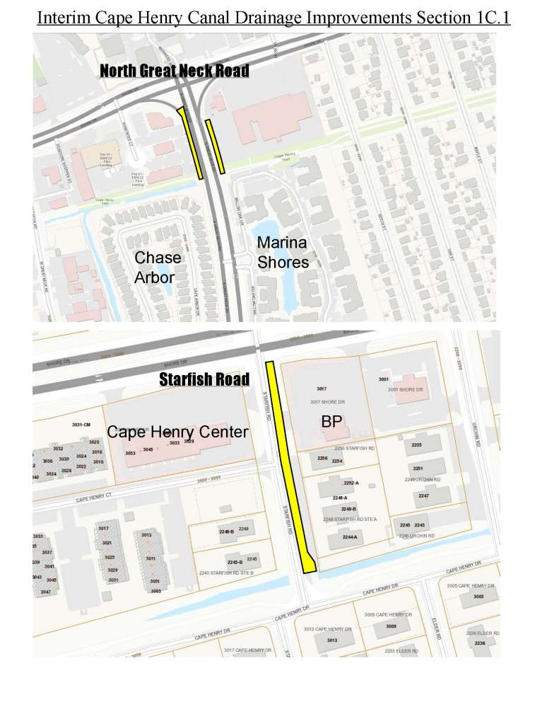
Crews will begin work at the intersection of Starfish Road and North Great Neck Road for the first phase. The project will include installing stormwater piping, drainage structures, trenching, along with sidewalk and pavement work.
Questions?
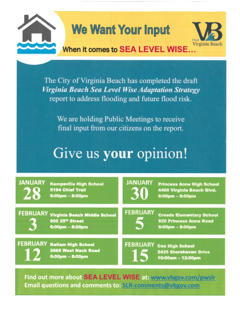
Final Sea Level Wise happening today!
We want YOUR input When it comes to Sea Level Wise public meeting dates.
February 15th 10am – 12pm Cox High School
Address: 2425 Shorehaven Drive
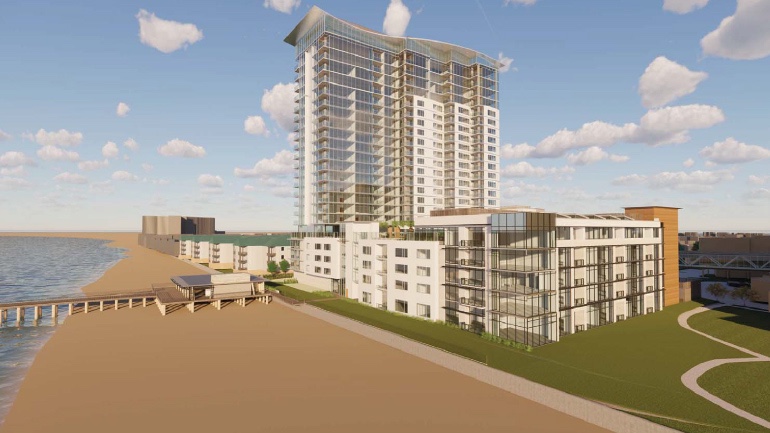
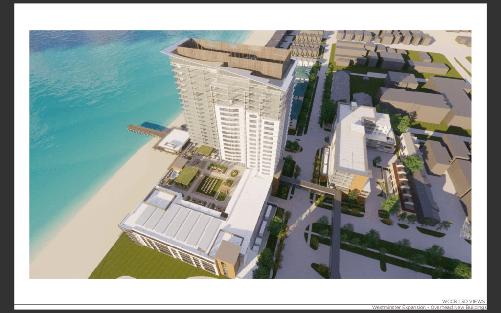
WCCB – Westminster Canterbury by Chesapeake Bay- has been “working with the City for about a year” on redeveloping 16.88 acres in the bayfront.
Planning Commission is scheduled to have a public hearing and vote as soon as MARCH 11 ’20.
CLICK HERE to start 8 question SURVEY.
SURVEY ENDS March 10. PLEASE TAKE IT NOW and share it.
We will be making the Survey results public.
Thank you!
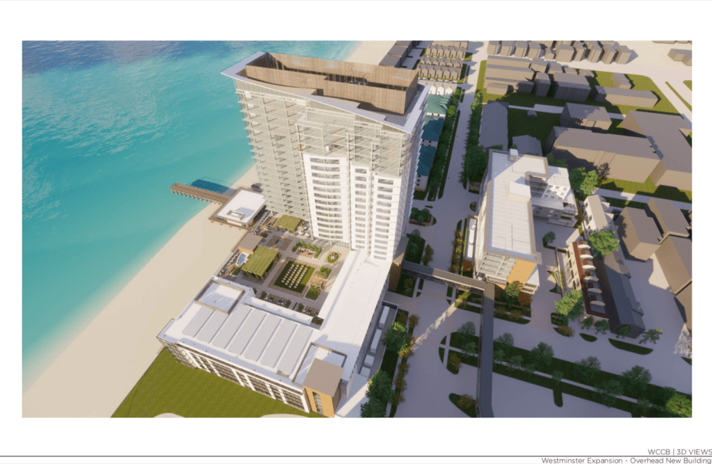
Rendering of proposed redevelopment that needs regulatory approvals.
View February 2020 Baylines Newsletter.
Bayfront Advisory Commission
Commission meets Thursday, Feb. 20, 2020 4500 First Court Road
Bayside Recreation Center
3:30 p.m.
Tentative Agenda:CALL TO ORDER
ELECTION OF OFFICERS 2020
MINUTES OF 1/16/20
CHAIRMAN’S REPORT – Charles Malbon, Vice Chairman
STAFF REPORTS & UPDATES
COMMITTEE REPORTS
Design
Communications
Public Safety, Transit, Parking & Pedestrian Access
BRIEFINGS
Comprehensive Plan update – Mark. E. Shea
OLD BUSINESS
NEW BUSINESS
COMMUNITY REPORTS & UPDATES
ADJOURN
Including more updates like:
Briefly…
The City Council has appointed William Hearst to the Bayfront Advisory Commission, replacing Scott Ayers, who retired …
View Powerpoint presented to City Council Informal Session FEB 4 ’20.
Just 3 of the questions to consider:
Was Parks & Recreation consulted re: the recreational boaters use of LBR&BF boat parking expansion being delayed again?
Was Public Safety & Traffic Engineering consulted re: recreational boaters backing up into the surrounding residential streets and onto Shore Drive in both west & east directions?
Was anyone tasked with studying the loss of revenue from the delay, again, of expanding recreational boat parking especially considering the recent loss of Boatel use?
Note: Questions are simply related to the location at LBR&BF of this proposed plan.
There’s potential expanding LBR&BF recreational boat parking could be delayed even longer as well:
Six (6) months – up to three (3) additional six (6) month terms for a
total of two (2) years
Learn more about Orsted at their website.
Ørsted ranked the most sustainable company in the world

View article at Pilotonline.com:
The City Council will hear more about the lease of the 5-acre site on Tuesday. A public hearing will be scheduled soon, said Vice Mayor Jim Wood.
View article at Pilotonline.com:
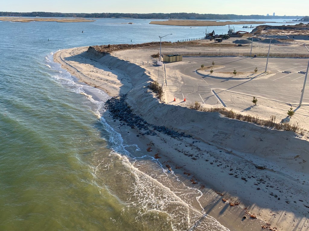
It also faces the costliest damage from today’s conditions, according to the city’s new sea level rise study. That’s true under short-term and long-term sea level rise projections, too.
From a project manager’s email about Phase 1C.2 stormwater work:
The 15-inch and 27-inch gravity sanitary sewer mains that will be relocated from under the Cape Henry Ditch to underneath Cape Henry Drive will remain gravity systems (not force mains). These mains drain down west all the way down to the Public Utilities Pump Station at Lynnhaven Colony Park.
We will be replacing the Sanitary Gravity Mains from Ebb Tide Road to Starfish Road, quite a long stretch, about 1,488 Linear Feet. The plan is to upgrade the 15-inch to 18-inch currently, but maintain the 27-inch size.
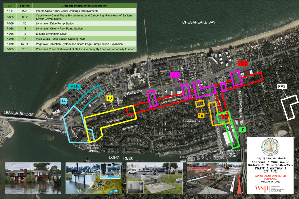
Note: Phase 1C.2 is in red.
Lynnhaven Colony Civic League Meeting will have a presentation by Westminster Canterbury of their proposed expansion. They propose building a 22 story building at the former Lynnhaven fishing pier with additional construction.
All welcome, need not be a member to attend.Sat, Feb 8, 9:00 AM – 10:00 AM
Dockside Seafood & Fishing Center
Address: 2425 Shorehaven Drive
View renderings supplied to City. ( 26 page PDF)
View Westminster Canterbury Modification of Conditions Application. ( 15 page PDF )
If Virginia Beach doesn’t take action to guard the city from more extreme flooding, its bond rating could be affected, officials have said.

After the flood models are completed at the city’s Public Works Stormwater Engineering Center, work begins on designing things like tidal backflow prevention devices. As seen Thursday, Jan. 16, 2020. (Stephen M. Katz)
Article has a terrific amount of info.
Our Comments(Discuss) are always open. You may remember Pilotonline.com Commenting has been turned off.
Finally, if you’re familiar with our work preserving Pleasure House Point, you may find a connection in this article.
The stormwater staff of the Public Works Department work to minimize flooding and protect the quality of Virginia Beach’s waterways by managing stormwater.
Resources include:
The City of Virginia Beach is currently updating its citywide stormwater master plan, which was first completed in the early 1990’s.
Lake Bradford & Lake Chubb Stormwater (CIP 7-053)
Current Update
RK&K was chosen to provide technical engineering services and will analyze the City’s Master Drainage stormwater model for Watershed 31 to identify drainage improvements within the Lake Bradford Drainage Basin. The stormwater model was recently completed and RK&K have begun their analysis. Lake Bradford and Chubb Lake were identified as part of Targeted Area 4 in the Norfolk and Virginia Beach Joint Land Use Study (JLUS) developed between Norfolk, Virginia Beach, the Hampton Roads Planning District Commission (HRPDC), and several U.S. Navy installations including Joint Expedition Base (JEB) Little Creek. Engineering design work has begun for two early drainage improvement projects.
Eastern Shore Drive Drainage Improvements
UNFUNDED DRAINAGE IMPROVEMENT PROJECTS
Section 1F – Neighborhood Storm Drain Improvements North of Shore Drive
Section 1G – Neighborhood Storm Drain Improvements South of Cape Henry Drive
Phase I, Section II Poinciana Pump Station and Outfall (Cape Story By The Sea): This project includes replacing the existing pump station on Sandalwood Road. Collection system improvements will be constructed along Sandalwood Road, Bayberry Street and Poinciana Drive. The current proposed outfall force main alignment is down the center of Maple Street.
Download the entire 306 page 106.6MB PDF report here.
A few highlights.
Executive Summary
In the last five years, the City of Virginia Beach has completed a comprehensive effort to develop strategies to respond to sea level rise and related increases in flooding. The study, known as Sea Level Wise, has produced a wealth of information to understand what challenges the City will face and develop diverse strategies to pro-actively reduce the impacts. This document presents the findings of the Sea Level Wise effort. . . .
Report includes:
A Call To Action
Maintaining Good Credit
The City’s flood risks are also recognized by organizations that rate the financial strength and borrowing ability of municipalities.In 2014, the credit rating agency Moody’s Investors Service Inc. sent a questionnaire to the City. It asked about the City’s sea level rise vulnerabilities, expenses, and plans to address future impacts. Thanks to the newly created Sea Level Wise program, the City was able to speak to proactive flood mitigation efforts underway, stating:
“The City firmly believes that the cost of damage done by ignoring sea level rise will far exceed the cost of mitigation.”
Satisfactory responses to these questions has allowed Virginia Beach to maintain a AAA credit rating. This high credit rating is essential for the affordable financing of City improvement projects through municipal bonds.
Page 8 Introduction.

Page 18 Community Engagement.
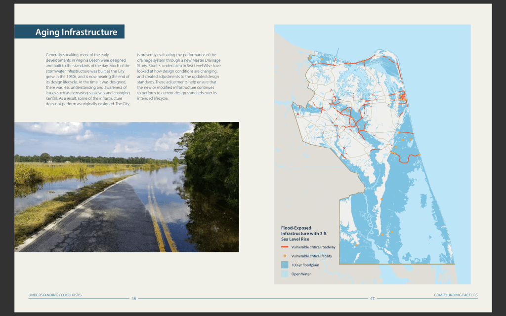
Page 46 Aging Infrastructure.

Page 58 Where are the losses occurring. Note Shore Drive area.

Page 72 City-Wide Objectives.
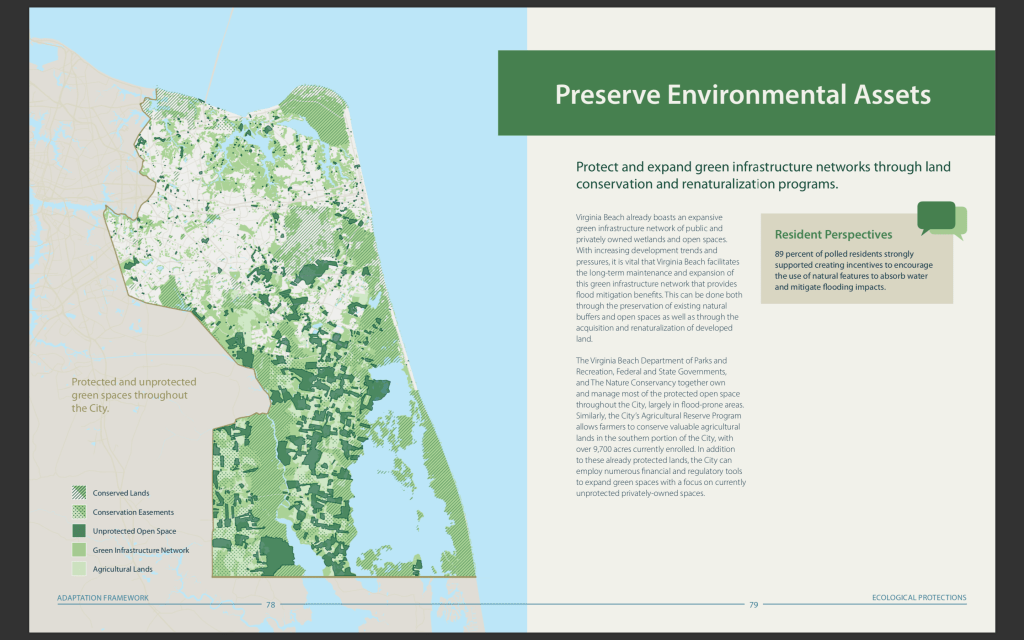
Page 78 Preserve Environmental Assets.

Page 104 Regulate Building and Development.

Page 110 Support Risk Mitigating Interventions. Note: “Priority areas for supporting risk-mitigating interventions at the parcel-level.”

Page 166 Lynnhaven. Note: “Over the last 40 years, this historically
agrarian community has undergone extensive development in both commercial and residential areas. However, the loss of naturalized landscapes has only served to make flooding worse, as development has formed on manufactured land and has surrounded the numerous water ways, rivers, tributaries, and bays that make up this region.”

Page 188 West of Lesner Bridge Neighborhood Alignment.

Page 190 East of Lesner Bridge Neighborhood Alignment.
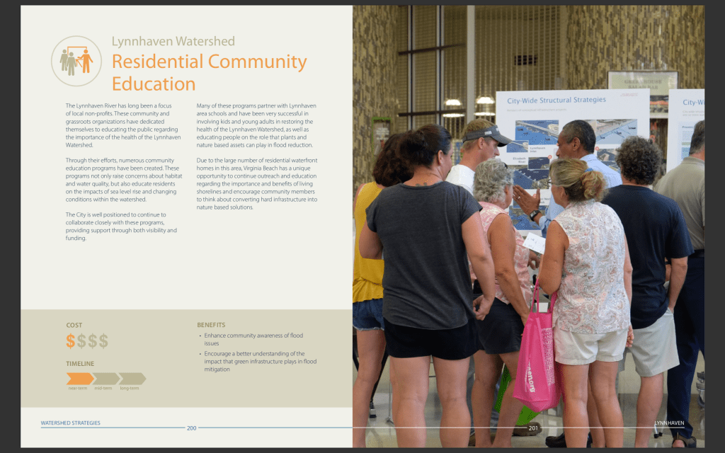
Page 200 Residential Community Education.
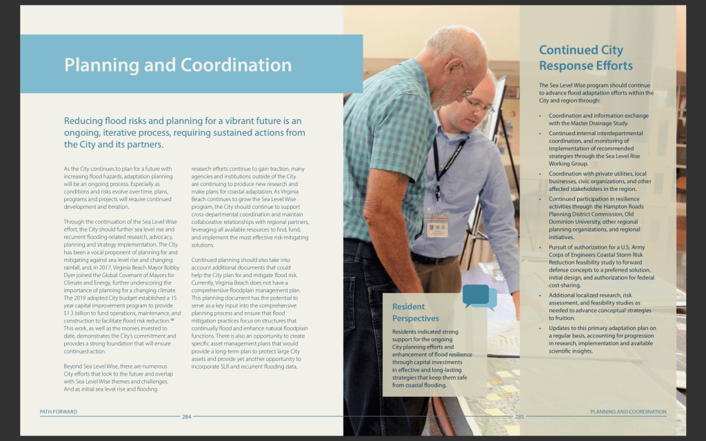
Page 284 Planning and Coordination.
Guess one of the top areas of VB at risk.
View article at Pilotonline.com:
Flooding in Virginia Beach is influenced by a host of factors. More intense rainfall, increased development on vulnerable lands and aging infrastructure have all contributed to more severe floods in recent years.