#LESNERBRIDGE update: “…not waiting for the old bridges to be completely removed before beginning construction of the new bridge.”

Pulled from official website page at VBGov.com:

April 6, 2017 Update​
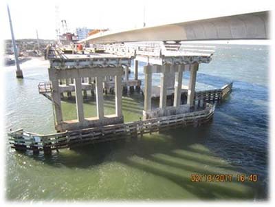
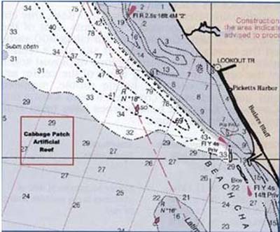
To All:

Since the last project update in December much has changed on the Lesner Bridge crossing Lynnhaven Inlet! On the evening of January 17th, 2017 the eastbound lanes of Shore Drive traffic were switched over to the new westbound Lesner Bridge thus completing Phase 3 of 5 on the project and preparing the way for the demolition of the old Lesner Bridges and the construction of the new eastbound Lesner Bridge. Demolition of both old bridges began on January 25th, 2017 and continues today. Contrary to what some folks believed, NO BLASTING will be used to in the demolition of the old bridges. In fact, the decks of the bridges have been strategically cut to allow each beam of each span to be removed individually. Most of the removed beams with attached deck will be transferred to barges for disposal at Cabbage Patch Reef located off the shoreline of Kiptopeke State Park. Some of the removed degraded beams were chosen by Virginia Tech to be saved and transported to Blacksburg for strength testing – but that is another story. The remaining piles of the bridge are cut off 4-feet below the ground surface if they are on land or are vibrated out if they are located within the water.


Center Steel Spans of the Old Lesner Bridges Removed

Pile Removal from Old Lesner Bridge

Cabbage Patch Reef Located in the Chesapeake Bay

Barge Loaded with Beam and Deck Sections of the Old Lesner Bridge


We are not waiting for the old bridges to be completely removed before beginning construction of the new bridge. All of the foundation piles from bridge abutment A (west side of the Lynnhaven) have been installed and the first of three concrete pours for the footing was completed on 3/28/2017. The four drilled shaft foundations for Pier column #1 were completed today, March 30th and over the weekend crews will move drilling equipment over to the cofferdam already installed for Pier column #2.

Completed Footing Base at Abutment A

In summary, the following work has been completed since the last project update (12/21/2016):​
​​​

    All Shore Drive traffic moved to the new westbound Lesner Bridge;
    Approximately 40% of the old Lesner Bridges have been demolished;
    All wick drains located at both bridge abutments have been installed;
    All of the remaining piles for Abutment A have been driven;
    The footing for Abutment A has been completed;
    The steel reinforcing for the segment pedestal and backwall at Abutment A has been installed;
    All four drilled shafts for Pier Column #1 have been installed;
    Retaining walls for new sidewalk installed along the southeast corner of East Stratford Street and Shore Drive.

​​
AMI, Inc. in Portsmouth, continues to build the superstructure of the new Lesner Bridge. A total of 102 of the 168 segments have been cast for the new eastbound bridge. It is expected that all bridge segments for the eastbound bridge will be cast by August 2017.​

Over the next two weeks, the bridge contractor will:
​​

    Continue Bridge Demolition;
    Install the drilled shaft foundations at Pier #2;
    Complete the construction of Abutment A;
    Continue filling and grading operations at the new bridge abutments;
    Install the new traffic signal pole and foundation on the southeast corner of Shore Drive and East Stratford Street;​
    Begin excavation for the leveling pad of the new MSE wall along the south side of Shore Drive between East Stratford Street and the new bridge;
    Begin installation of the steel falsework between Abutment A and Pier #1 to support the segment assembly gantry crane.​​

That’s it for now. P​lease drive safely!

-Chris

April Baylines from Bayfront Advisory Committee

View April Baylines. (PDF)

This edition includes info like:

Years of planning will culminate April 20 when the Public Art Virginia Beach Foundation and artist Donald Lipski unveil the design for the public art creation that will be erected on the southwest side of the new Lesner Bridge at the Bayfront Advisory Committee meeting.

The meeting, open to the public, will include presentations by Lipski and Foundation Chairman Andy Fine discussing and showing the inspiration behind the artwork. The presentation will take place at the 3:30 p.m. meeting in the Sunset Room of the Virginia Beach Resort Hotel and Conference Center, 2800 Shore Drive.

The rumor about Lesner Bridge budget cuts are true. Your voices were heard. 

(April Fools)

Because of federal budget cuts rippling through to the state, a deal was made early this morning for COVB to keep some of the monies set aside to complete the Lesner Bridge. 


One of the ideas is to study if it’s feasible to keep part of the old Lesner Bridge still standing as a public open space pier. 

(Two engineers we’ve been speaking with feel it should be very doable.) 

Ultimate plan would be for a public, private partnership to finance the maintenance & operation of Lesner Pier as it might be called. 


The rest of the saved funds could go to other various projects like upgrading storm water improvements. 

“How can we make walking and biking better in Virginia Beach?”

Let’s do it again Shore Drive!

(Remember: you MUST sign in to have your voice heard. You do NOT need to share your name publicly. “Off Forum” comments are “not counted”.)
Start short survey here at VBGov.com’s Virtual Townhall:

Residents have expressed interest in improving alternatives for people who wish to navigate the city without an automobile. But walking and biking around some areas of Virginia Beach can be difficult. The city is reaching out to citizens for input on how we can make it better.

“The Governor has signed the legislation dealing with Online Rental Platforms. It will become effective on July 1st of this year.”

Letter to Ad Hoc Committee. (1 page PDF)

New Virginia Online Rental Platform Legislation.(10 page PDF)


C. 1. If a locality adopts a registry ordinance pursuant to this section, such ordinance may include a
554 penalty not to exceed $500 per violation for an operator required to register who offers for short-term
555 rental a property that is not registered with the locality. Such ordinance may provide that unless and
556 until an operator pays the penalty and registers such property, the operator may not continue to offer
557 such property for short-term rental. Upon repeated violations of a registry ordinance as it relates to a
558 specific property, an operator may be prohibited from registering and offering that property for
559 short-term rental.
560 2. Such ordinance may further provide that an operator required to register may be prohibited from
561 offering a specific property for short-term rental in the locality upon multiple violations on more than
562 three occasions of applicable state and local laws, ordinances, and regulations, as they relate to the
563 short-term rental.
564 D. Except as provided in this section, nothing herein shall…

Remember taking the survey? Transit Planning Public Engagement Summary February ‘17.

First off, THANK YOU For participating in survey if you did.

Your feedback DOES make a difference.

View entire PDF at VBGov.com here.

View & download entire Transit Planning Public Engagement Summary (86 page PDF)

There are a ton of great well thought out comments in the entire package.

Some sample feedback including 215 first place votes for Shore Drive Ocean Park Phase IV roadway project.

March Baylines from Bayfront Advisory Committee

View Baylines here.

“Outreach ‘17” signup deadline extended

The deadline for Bayfront neighborhood organizations to place themselves on the invitation list for an upcoming outreach meeting has been extended. The Bayfront Advisory Commission plans to hold a meeting later this spring or early summer to solicit suggestions from civic leagues, condominium officials and neighborhood associations about their most-pressing issues and concerns.

Called “Outreach ’17,” the meeting or meetings will assist the City-Council-appointed Bayfront Advisory Commissionwithsettingprioritiesforthecomingyear. Theextensionwillallowthoseneighborhoodgroups who meet less frequently than monthly to poll their memberships about their most-pressing concerns and to appoint a contact person from the organization.

When scheduled, “Outreach ‘17” will be public.
To place a neighborhood on the invitation list, please send contact information to Scott Ayers, BAC Communications Committee chairman at bayfrontadvisorycommissionvb@gmail.com. Reach him by phone at (757) 671-3343.

Article & photos of old #LESNERBRIDGE 

View at Pilotonline.com. 

Another article & photos here also at Pilotonline.com today.


2nd photo from construction cam capturing blizzard of March 3rd ’17. 

Governor McAuliffe Announces Updates to Virginia Flood Risk Information System

View Press Release:

The new VFRIS was developed by the Virginia Institute of Marine Science’s Center for Coastal Resources Management in partnership with the Virginia Department of Conservation and Recreation, the agency responsible for the state floodplain management program.

“Flooding is the most common natural disaster our we experience in the Commonwealth, and our Hampton Roads and Eastern Shore communities are particularly at risk for severe damages caused by recurrent flooding.” said Governor McAuliffe. “It is my hope that VFRIS becomes a mainstay for homeowners, businesses, and communities going forward. March begins Flood Safety Awareness Month and I encourage all Virginians to access VFRIS to see how a flood might affect their home or business.”

View Virginia Flood Risk Information System (VFRIS) info:

Virginia Flood Risk Information System (VFRIS) is a collaboration between DCR and the Virginia Institute of Marine Science’s Center for Coastal Resources Management. VFRIS helps communities, real estate agents, property buyers and property owners discern an area’s flood risk.

Launch VFRIS here.

Click screen shot to Launch VFRIS

Click screen shot to Launch VFRIS

Boat shop in Ocean Park robbed Super Bowl Sunday night. “King is asking anyone who may have seen anything suspicious in the area between 7 p.m. Sunday night and 2 a.m. Monday morning to call police.”

Check story including video at WTKR.com.

“When all the damage is done, or how they pulled it out of the dash, all the steering and everything we are talking well over $200,000 of motors,” King told News 3’s Todd Corillo Wednesday.

There’s a short Survey at VBGov.com that could help get Shore Drive upgraded in Ocean Park.

Question #9 please choose Shore Drive !

Question #9 please choose Shore Drive !

Help Ocean Park!

Question 9. Please rank the following roadway projects 1-8 in order of priority, with 1 being the highest priority and 8 being lowest. (Project | Unfunded Amount)
Please choose “Shore Drive Corridor Improvements Phase IV as #1 or slide it to top.

Extra bonus points.

Question 8. What else should we consider as we plan the future of public transit in Virginia Beach and the region?
Answer Question #8 by Write in: We want Shore Drive/Oceanfront Trolley Loop

Even more love for Ocean Park & Shore Drive.

Question 10. If you have any additional comments or questions, please write them here:
Write in: PLEASE FINISH SHORE DRIVE PHASE IV NOW

Click to start short survey.

#LESNERBRIDGE 1 lane each direction Wednesday Feb 1 from 9a-3p

From an email from Bayfront Advisory Committee:

BOTH directions of Shore Drive over the Lesner Bridge will be reduced to ONE LANE between 9 a.m. and 3 p.m. Wednesday, Feb.1, as crews repair a leaking 16-inch water main line. Affected lanes for this closure will be the INSIDE lanes both east and west bound, said Christopher J. Wojtowicz, project manager. Repairs will be done on Shore Drive at Vista Circle eastbound and at Page Avenue westbound.

114-136 (1)

“Westbound traffic on the Lesner Bridge will be reduced to one lane at Shore Drive and Page Avenue tomorrow, Tuesday, Jan. 31, between 9 a.m. and 3 p.m….”

From Bayfront Advisory Committee email:

“. . .said Christopher J. Wojtowicz, project manager for the bridge replacement. The outside, right lane, will be closed while repairs are made to a shock-absorber-like “impact attenuator” that had been hit and to fix the concrete collar around one of the drainage inlets in that lane closest to the sidewalk. Plans call for the work to be completed and the lane reopened no later than 3 p.m.”

Screen shot of construction cam at 100pm January 30th 2017.

Screen shot of construction cam at 100pm January 30th 2017.

“I wanted to give back to my community and bring people together through a collaborative project that everyone could enjoy,” she said.

Check out article at Pilotonline.com.

Photo courtesy of Michaella Lynch

Photo courtesy of Michaella Lynch

“Public Works Waste Management collections will resume on Tuesday, Jan. 10 on schedule since there are no Monday collections. Due to road conditions, service may be slower than normal. Residents should leave bins out until crews can get to them.” And more updates . . .

City Working to Get Roads and Services Back ASAP at VBGov.com:

“The first priority is to make passable approximately 900 lane-miles of primary roads and an additional 300 lane-miles of priority streets that access hospitals, fire stations and police stations within 12 hours after snow stops falling,” said Phil Davenport, director of Public Works. “Neighborhood streets are not cleared because parked vehicles and other safety considerations make snow removal from these streets impractical or far too costly for the couple of storms we get each year. The process goes much quicker when citizens refrain from driving and streets are free of traffic.”

Main Winter storm update page at VBGov.com.

Pleasure House Point during Helena on Saturday. Photo Credit: Tim Solanic

Pleasure House Point during Helena on Saturday. Photo Credit: Tim Solanic