
Read about PD-H1 in the City Code.
PD-H1 also references A-12 here.
Read about P-1 in the City Code.

More about zoning request change for Pleasure House Point at VBGov.com/PleasureHousePoint.
Read about PD-H1 in the City Code.
PD-H1 also references A-12 here.
Read about P-1 in the City Code.
More about zoning request change for Pleasure House Point at VBGov.com/PleasureHousePoint.

Stands for those whom we play golf with at private clubs; personal agenda for pet projects with friends and campaign contributors, and too much city business as usual. Stands for Good Ol’Boy System. I guess if we wanted to hear more answers to our questions, we would have a private invitation to play golf with some of our elected and appointed city officials.
SDCC recently posted the 28 questions that were presented to Chairman Fraim of the Beaches and Waterways Advisory Commission (B&WAC) at the city’s official and only public hearing held OCT 13, 2011. Now, almost one year ago. As some of you who attended this public forum for the Neighborhood Dredging (Spoils) Program, these questions were officially presented in writing to the chairman and were to be officially answered by this officially appointed city commission. The city would like citizens to think that our voices are heard on such important matters as this costly program (potentially $100 million) directly impacting citizen safety and our tax dollars. All that I can say is that SDCC has not received any satisfactory answers from either the city or the B&WAC chairman, although their official report was submitted to the city nine months ago.
Why are the city and the B&WAC chairman so quiet? I believe that they can not answer SDCC’s questions related to neighborhood impact, safety, environmental issues, traffic impact, costs, and operational concerns of this program. If they cannot answer my questions satisfactorily, how can they continue to proceed with the Neighborhood Dredging (Spoils) Program? I have forwarded these questions to Councilwoman Wilson (City representative to the B&WAC) a month ago to see if she could pry required answers out of the city, and so far no response. Bottom line- NO ANSWERS. It may not be that important, but it does concern public safety, impact on neighborhoods, impact on traffic through three major school areas, and your present and future tax dollars. WHY no answers? Maybe there are no responsible answers.

He draws from such inspirations as fellow Augustan, the Godfather of Soul himself, Mr. James Brown. In fact a local radio personality said it best “If Elvis Presley and James Brown had a child, it would be no other than Brandon Bower”.
VBGov.com/PleasureHousePoint for all other info like maps, graphs, polls, Stakeholder meeting minutes, discussion, etc.
Coming out OCT 13 for LRNow Fall Festival right ?
BRANDON BOWER is one of the musicians playing for the Celebration.
Stay tuned to find out who else is.
From an email from Chris
There were some questions as to the road improvements on Great Neck. Per the City, they are offsetting the turn lanes to improve visibility. There have been 15 accidents at the intersection in just the last 5 years, so apparently it is pretty dangerous. Many of those reported as drivers in the lefts being unable to see oncoming traffic due to vehicles in the opposing left turn lane.
In FY10 the City applied for and was approved to receive federal Highway Safety Improvement Program (HSIP) funds for the project, so it is being funded by the Feds.
The improvements will be completed by early December
The Bayfront Advisory Committee will meet Thursday, Sept. 20, at the Virginia Beach Resort and Conference Center, Lynnhaven Room, 2800 Shore Drive, from 3:30 to 5:30 p.m.
Click here for more information http://www.vbgov.com/news/Pages/selected.aspx?release=974
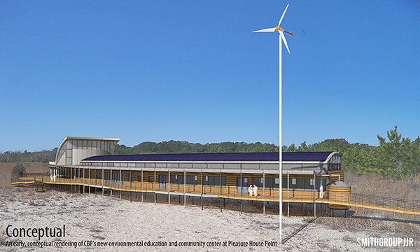
Pleasure House Point
Open House for Information on Chesapeake Bay Foundation Plans
Tuesday, September 18, 2012
6:00 p.m.-7:30 p.m.
Bayside Recreation Center, 4500 First Court Road, Virginia Beach
We invite you to an open house to review plans for an Environmental Education Center at Pleasure House Point.
A partnership with Chesapeake Bay Foundation (CBF), City of Virginia Beach, Trust for Public Land, and many citizens from your community successfully protected Pleasure House Point (PHP). Ninety-two percent of the preserved land is now the PHP Natural Area, managed by the City of Virginia Beach. CBF and its partners will utilize the eastern 10 acres for environmental education programs and an environmental center. At the Open House, CBF staff will be available to answer any questions.
Questions? Contact Christy Everett, CBF, at 622-1964 or ceverett@cbf.org.

SHARE THE ROAD
Motorists have a responsibility to share the road with those who enjoy biking and walking along Virginia’s roadways.
When you pass a bicyclists slow down and allow at least 2 feet between the bike and the vehicle.
Look for hand signals a bicyclist may use to signal a turn. When approaching a crosswalk, stop for pedestrians.
Bicyclists have the same rights and responsibilities as motorists and should ride with traffic.
Bicyclists should obey all Virginia traffic laws, use flashing lights, and wear bright clothing.
Bicyclists should yield to pedestrians.
If you’re out walking, move against traffic and use sidewalks when possible.
Read the entire article at Pilotonline.com.
“I am ecstatic with an environmental educational component existing on PHP run by CBF,” he wrote in an email. ” – they can simply do much, much better.”

LEARN MORE AT THIS FACEBOOK THREAD!
[No need to be a member of Facebook.]
From their neighborhood watch:
A new house under construction at 2764 Ocean Shore Ave. was broken into Saturday or Sunday 9/1 or 9/2. Graffiti was spray-painted on wood and windows inside the house and two tubs were damaged with a sledge hammer. If anyone has any information on this break in, please call the police at 385-5000.
Hello Volunteers!
Dr. Douglas Tallamy, Professor and Chair of Entomology and Wildlife Ecology at the University of Delaware and the author of the book Bringing Nature Home is the featured speaker at the Go Native! plant symposium.
The event will be held on Wednesday, September 12th at First Landing State Park in the Trail Center. Tickets are $20 each and includes parking and refreshments. A portion of the proceeds will go to First Landing State Park.
If you are interested in attending or would like additional information, please contact Renee’ Wampler at 757-425-0724 or email pagcrw@cox.net.
Thank you,
Kim Y. Miller
Volunteer / Events Coordinator
First Landing State Park
Phone: 757-412-2308
Cell: 757-536-0088
Fax: 757-412-2315
Read the entire article and comment at Pilotonline.com.
The person with the best guess will win a gift basket from Taste Unlimited worth $50, he said.
Editors note: People who think the world is their ashtray are a$$hole$ buttheads.
More at VBGov.com News Center.
FBI Special Agents from the Norfolk Field Office will provide detailed and interesting information on threats from child predators.
