REUNITED

REUNITED
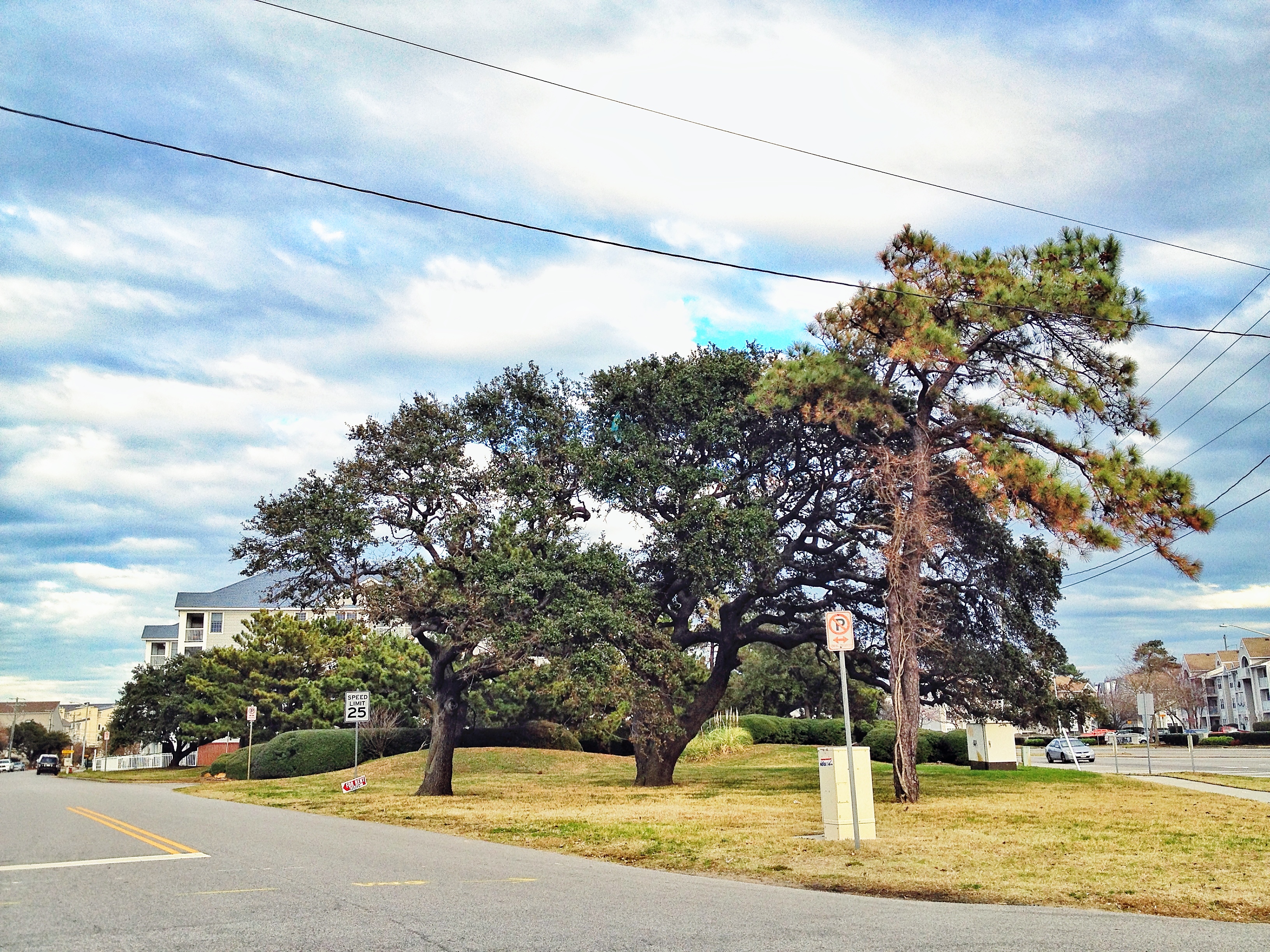
East bound Shore Drive toward N Great Neck Rd currently closed.
Update: appeared cleared about 1155am.
Anyone else with info?
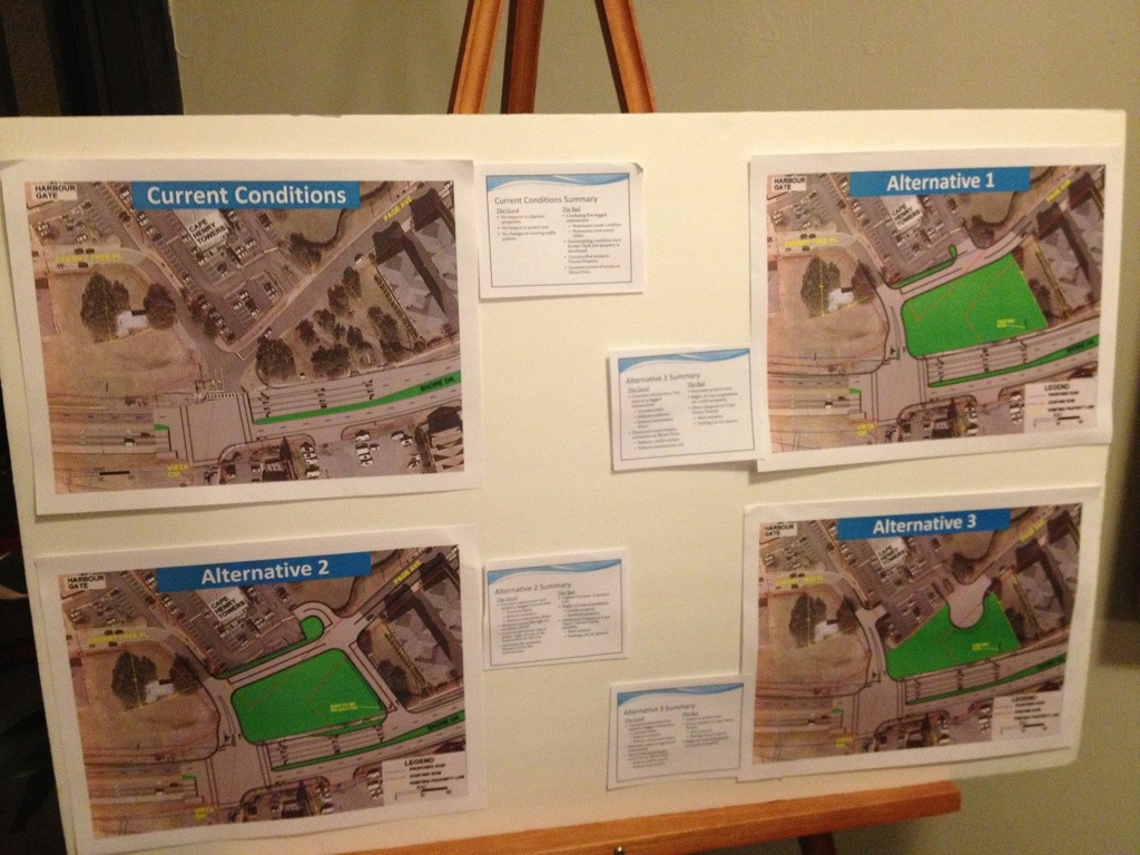
Thanks to Public Works Project Manager Jason B. Wilson for sharing the proposed changes for the intersection of Page Avenue and Shore Drive.
View the CHT Presentation Final (12 page PDF).
This is part of 2.117.000: Shore Drive Corridor Improvements – Phase III.
Learn more about Shore Drive infrastructure work at SDCC.info/HOT.

Alternative 1 for proposed realignment of intersection.
View from Page Avenue looking east down Shore Drive.
An excerpt of a comment from previous post at SDCC.info about this proposal:
I don’t understand the reason for ANY if these three proposals. Even when Duck In was hosting their famous Friday night parties, everyone (even drunk drivers) managed to exit onto Shore Dr without problems.
Bolt cutters were used on the airplane steel cable type locking device. Bike was a Christmas present from 2011. It was stolen between 1-5p.
Why share this? Bolt cutters were used.
From Cape Story neighborhood watch.
Download the 59 page PDF here.
Public Works repaired the beach steps in Ocean Park:
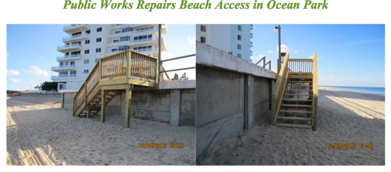
High winds and water in the Chesapeake Bay from Hurricane Sandy took their toll along the bay front. One casualty was the existing wooden step beach at East Stratford Road that was washed away. Public Works dispatched a crew to the area last week where they made the needed repairs and reconstruction. The beach access has re-opened and is available to the public in the Ocean Park community.
Visit www.TPL.org and donate to receive your hard copy. The digital copy is not yet available – except – in the 59 page PDF above, or download this 12 page PDF to read the story. It’s a great article. Full disclosure: yours truly is in it chatting about the SavePHP idea along with your neighbors Karen, Tom, Cindy, Mike, Whit, & Chris.
Arena Town Hall Meeting to Be Held Tuesday Dec. 18th
The newly formed Citizen Advisory Committee for the proposed arena project will hold a public Town Hall meeting on Tuesday, Dec. 18, from 6 to 8 p.m. at the Virginia Beach Convention Center to gather input from citizens. The Convention Center is at 1000 19th St. The meeting will be in Suite 1.
Click here to read more about the meeting. http://www.vbgov.com/news/Pages/selected.aspx?release=1154
City of Virginia Beach Launches Virtual Town Hall
New Software Program Promotes Citizen Engagement
Today, the City of Virginia Beach launched a new Web-based citizen engagement tool called Virtual Town Hall that will help the city gather residents’ opinions about city projects and initiatives, with the goal of incorporating this feedback in the decision-making process.
Click here to read more about the tool and to sign up. http://www.vbgov.com/news/Pages/selected.aspx?release=1166
Hoo ray!
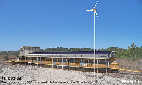
Photo credit: CBF
“We are extremely gratified that the Virginia Beach City Council and the community support our new venture at Pleasure House Point,” said CBF Hampton Roads Director Christy Everett. “The CBF Brock Environmental Center will be a model of sustainable design, demonstrating how it is possible to build responsibly and make a substantial environmental difference without sacrificing comfort or aesthetics.”
The CBF Brock Environmental Center will feature cutting-edge green construction practices to meet the “Living Building Challenge,” a set of stringent, specific environmental standards established by the International Living Future Institute. These standards require the facility to have “net zero” impact on the environment, not only during construction but during its daily operation. It will be the first of its kind in Virginia.
More including video at WAVY.com.
Learn more about the possibility of trees coming down for duplexes within site of CBF’s facility here and here.
Click here for a printable version of the agenda SDCC Agenda DEC 2012
Shore Drive Community Coalition
Monday 17 DEC 2012
SDCC General Meeting, Election & Party
PLEASE NOTE DATE and TIME
SDCC General Meeting – Monday, 17 DEC 6:30 – 9:00 pm
Ocean Park Volunteer Rescue Squad Station (Intersection of Shore Drive and East Stratford Rd.)
Call to order
Meeting topic: VOTING and ELECTION of SDCC Officers for 2013
2013 Slate of officers approved at Nov. Meeting:
President – David Williams (Cape Henry Shores)
Vice President – Rick Mercadante (Ocean Park)
Secretary – Todd Solomon (Cape Story)
Treasurer – Ryan King (Chesapeake Beach)
Member’s and Guest’s SOCIAL CELEBRATION of 2012
Officers’ Reports:
President’s Report David Williams
Vice President’s report Grace Moran
Secretary’s Report Todd Solomon –NOV Minutes
Treasurer’s Report Carol Collins
Update on issues:
Old Business
New Business Celebrate /Pollard’s Chicken, meatballs, veggie tray, cheese tray, and dessert tray
Adjourn
Next SDCC- Monday JAN 28, 2012
Ocean Park Volunteer Rescue Squad Center
Speaker- TBA
Please check http://www.sdcc.info for more information on area news and events
This could be similar to what to expect for the Lesner Bridge replacement work.
Check out FIGGBridge.com.
More links and info at SDCC.info’s HOT page about the Lesner Bridge replacement.
Yeah. Me neither.
At Cape Henry Towers. Plans from a couple months ago. More info to follow I’m sure.
The following is an email from the Deputy City Manager, Dave Hansen, to the Bayfront Advisory Committee (BAC) explaining the LED Traffic signs on Shore Drive and the Intelligent Transportation System (ITS) project. You can also see the 2009 Power Point presentation given by City Staff to City Council regarding this project. Click here to view the 3Mb file. ITS Brief 021810
Members of the BAC,
In November of 2009, DPW Jason Cosby briefed the City Council on the $22M Intelligent Transportation System project in which all but $1.5M was being funded by the Federal Highway Administration. In this comprehensive briefing he covered the major phases of construction and their specific outcomes. I have attached that brief and note that on chart #24 we identified the location of 6 sites where the Dynamic Message Boards were to be installed. Two of those locations were clearly shown on Shore Drive. Following that briefing Mr. Cosby briefed the BAC on 18 February 2010. I have attached that briefing and ask that you relook charts 21-26. Additionally I have attached the minutes of that BAC so that you can see who was in attendance when we advised you what the plan was, why it was and what it was to be like. As Mr. Arnhold made comment regarding City staff in his email below, I note that he was in attendance at the BAC brief on 2-18-10 and that no questions were posed to the staff following the DPW brief. The lag time between the briefings and the start of construction was the product of contracting, funding, technology, public briefings and increasing the requirement from six to eight locations. Hopefully the board recalls this information briefing in February 2010 and we can proceed to respond to the myriad of questions which are being asked. To assist you I provide the following description of the ITS project and specific information on the DMS.
The signs located on Shore Drive are part of The Virginia Beach Dynamic Message Signs and System Detector Project which consists of the installation of 11 motorists advisory Dynamic Message Signs (DMS) at eight locations, overhead sign support structures, equipment cabinets, and communication equipment. The DMS’s have three line displays. This important project was funded by Federal Funds associated with Congestion Mitigation and Air Quality and is intended to provide real time information to the motoring public to keep traffic flowing. The locations have been strategically selected and approved by City Council in order to maximize the dissemination of essential information to motorists. The DMS’s will be installed at eight locations within the City.
The DMS’s will be installed at the following locations:
1. Princess Anne Rd and Elson Green Ave, southbound
2. General Booth Blvd at the KOA Campground, northbound
3. Shore Dr and First Landing State Park, westbound
4. Shore Dr and Bayville Rd, back to back DMS’s
5. Northampton Blvd and Bayside Rd, eastbound
6. Northampton Blvd and Shell Rd, westbound
7. Independence Blvd and Wakefield Dr, back to back DMS’s
8. Shore Dr near 83rd St, back to back DMS’s
What follows is a brief summary of the why, what, how, and where:
1. Purpose:
-The primary purpose of the signs is to convey traffic condition information to the roadway motorists
– Signs are especially useful during hurricane evacuation
– Signs can be used to display public safety campaign information (i.e. Amber Alerts, Click-it-or Ticket)
2. Lighted:
– signs will not be lighted (no illumination lamps to shine on them); they are LED driven-internally illuminated
– the sign will be dark unless there is a message to display
3. Size: 6 feet high by 12 feet long; mounted 17 feet above the ground. (by comparison our portable signs are 6’ by 10’)
4. Location: The location on Shore Drive was specifically selected because of the following properties: -38,000 motorists pass this site every day
-West bound traffic can be alerted to conditions at Northampton Blvd, Chesapeake bay-Bridge Tunnel, and I-264
-East bound traffic can be alerted to downstream conditions on Shore Drive, Fort Story, Great Neck Road
The signs are a part of our ITS (intelligent Transportation System) project with the goal being able to disseminate real-time traffic information expeditiously to the motoring public. They can also be used to broadcast Amber Alerts in support of Public Safety.
Should you require additional information I am happy to respond to your RFIs. Regards, Dave
Dave Hansen
Deputy City Manager
City of Virginia Beach
(757)385-4242
From Cape Story Neighborhood Watch:
My house that is under construction in the 2200 block of Maple Street (near the bike path) was vandalized last night by 3 high school age youths. A neighbor was on an evening walk after 9:00 pm and had seen them walking around. Then he just happened to be walking nearby our house and heard the loud crash of smashing windows and called 911. He actually chased after them calling out help, help to alert the neighbors. They are most definitely local kids as one had his skateboard with him. They were described as follows: 2 of the boys being tall and thin, and the 3rd boy was shorter than the other two. They smashed two lower windows in the living room from inside the house with a board. Four VA Beach police cruisers responded and searched the property and the neighborhood, but did not find these young vandals.
The fact that this looks to be neighborhood kids is especially concerning. I have two teenagers myself, and if I were reading this and had a high school age son, I would be asking myself “Where was my son last night between 8:30 pm and 10:30 pm”.
This is not a personal safety issue, but it is a nasty bit of vandalism for sure. My guess is that if these kids get away with this they will vandalize others. If anybody has any information as to who might have done this, we would greatly appreciate them coming forward.
Please remember to call 911 if you see a crime in action and call 385-5000, option 1, to report crimes after they have occurred or to report any suspicious activity. Also, please call or email the NW Coordinator so crime reports and suspicious activities can be shared with all of our residents.
Hampton Roads Transportation Planning Organization (HRTPO) would like your help in long range planning for our region. Read their information below and Please take 5 minutes to answer their online survey.
The Hampton Roads Transportation Planning Organization (HRTPO) is updating the Long-Range Transportation Plan. Entitled Navigating the Future to 2040, this plan will address future road, transit, passenger rail, freight, bicycle and pedestrian needs for the region. Because these are your needs, and because this plan will directly impact you and shape your quality of life, we want to hear your perspective and opinions on vital transportation issues in the region. In this way, we can mutually shape a vision for Hampton Roads. Help us navigate the region’s future! This short survey should only take about 5 minutes to complete and will be used to help guide transportation in Hampton Roads. We thank you for assisting us with identifying these issues, and enabling us to direct resources to solving these needs.
IN JUNE 2010, Virginia Beach’s City Council banned electronic signs in the city, calling them garish, distracting to drivers and dangerous. Rather than impose stringent restrictions on signs in front of churches and businesses, the council said the bright signs, if not already in place, would not be allowed at all.
That vote was in character with the city, which banned new billboards a quarter-century ago and encouraged landscaping and beautification projects in medians and other public spaces.
City government itself is exempt from the electronic sign ordinance, however. Light-emitting, attention-grabbing signs beckon passersby to Virginia Beach’s convention center and its performing arts center. Outside public schools, libraries and community centers, the signs are colorful reminders of upcoming events.
Now, according to reporting by The Pilot’s Kathy Adams, the city is erecting eight LED signs to warn drivers about traffic problems on Shore Drive, Princess Anne Road, and Independence, General Booth and Northampton boulevards. Not only are city officials defying the spirit of the ordinance, but they failed to talk to neighborhood groups about the signs’ locations, size and hours of use.
Traffic engineers determined the locations. The federal government paid for the $60,500 signs with “congestion-mitigation” money.
So now, instead of the city partnering with private companies that own the 30 billboards in Virginia Beach to allow limited electronic messages and city use for public safety issues — as some on the City Council had proposed in 2010 — the city has eight more signs towering over roadways.
Monday-morning quarterbacking does no good unless it serves as a lesson for the future. In the case of LED signs, the city failed a basic tenet of good government: It didn’t involve affected communities in the planning.
Virginia Beach should have solicited suggestions for designs that don’t run afoul of the aesthetics of the surroundings. It should have asked the public for ideas for traffic alert locations that would actually help drivers with alternative routes.
And because the city violated rules that bind the rest of us, it should have made the case publicly for why its signs are a safety feature, not a hazard.
By Selene D. Guerrero, Correspondent Virginia Pilot
Residents of Lynnhaven Colony filed into Dockside Restaurant on Nov. 17, but instead of appetites they brought questions for the public works officials in attendance. The city panel and more than 50 residents gathered to discuss solutions to the neighborhood’s common flooding during high tide and inclement weather.
“The most important and expensive thing you purchase is your home,” Donna Rennick, civic league vice-president, told Phillip Davenport, public works director, before he took the floor.
“We need to know how we can work with you,” Rennick said. “We need answers.”
Phillip Roehrs, water resources engineer, presented a project that officials believe would alleviate most of the flooding, but further study is needed to make certain it will do the job. Lynnhaven Colony is south of Shore Drive, on land that is between the Chesapeake Bay and Long Creek, which is a tributary of the Lynnhaven River. According to a 2005 study, solving the core problems – feeder ditch improvements, flooding on Shore Drive, relieving flooding in low-lying areas – is estimated to cost $50 million, Roehrs said. Roehrs added that he was not prepared to provide the residents a timeline of when the project would begin or be completed.
“We’re at a point where we are thinking of moving,” said Joyce Dunn, a 30-year resident. “After the 2009 nor’easter, the city proposed the same and nothing has been resolved.”
Dunn’s family has made costly adjustments in their home, such as resurfacing their garage and moving their furnace to the attic. In about a year, when sidewalk construction on Shore Drive begins, the city plans to start Phase I of the project by putting in the components needed for development of a flood-control system.
The final plan would provide the community with two tide gates, five water pump stations (adding to the two already in place) and an underground conveyance system. The current outfalls to the Chesapeake Bay and river would be improved with extra collection systems that would provide a better flow.
“There are minor tweaks in the works,” Roehrs said. “But it will take a number of years to build and a number of years to finance.”
Currently less than $3 million a year is set aside for the project. City officials are working to come up with a way to fully finance the project and move forward.
“Even if we are able to come up with a financing plan where we can have all the money today,” Davenport said, “we can’t do all of the work at one time, it has to be phased.”
Construction around the roads and ditches would make it difficult for residents to get in and out of Lynnhaven Colony, he said.
The city plans to put in place a funding and work schedule, and provide residents with a timeline by December 2013. In the meantime, city representatives suggested that homeowners have their homes elevated and seek federal funding with the Federal Emergency Management Agency through the Severe Repetitive Loss program.
“Set an expectation,” resident Vin Melwani told the panel after the presentation. “I’m a homeowner,” Melwani said. “I just would really appreciate it if you could set a realistic expectation.”
program, contact Erin Sutton, city emergency planner, at 385-1076.
Eastern Shore Drive Leaders,
Let me begin by attesting the Eastern Shore Drive Storm Water Drainage Area Improvement Initiative is one of our top focus areas as we roll into the new year. The staff and City leadership are very sensitive to the hardships created when we have intense and long-lasting weather events such as Sandy, Irene, and the Nor’easter of Nov 09. Following Public Works attendance and briefing last Saturday with the Lynnhaven Colony Civic League and concerns we have received from Cape Henry Shores, Cape Story By the Sea and other concerned citizens in the eastern Shore Drive drainage area, our engineering and operations staff will be undertaking an accelerated analysis of several interim solutions which have been suggested and on the face seem to have merit in providing various degrees of protection from tidal inundation. Below is a summary of the two phases I have asked our engineering staff to pursue. Phase I is a data map with summary descriptions so we identify all infrastructure, elevations and drainage areas east of the Lesner. Completing this on 7 Dec allows us to define the study aspects of Phase II. I have asked Public Works to complete their assessments and recommendations by the first week in April and to publish a written report NLT 12 April. Intent will be to post this report on-line for the civic leagues and citizens to review. Here are summaries of the first two phases:
1. Using City topographic mapping as the base, delineate the drainage sub basins, the drainage systems (open and closed), and the outfalls for the Lynnhaven Colony/Cape Henry/Cape Story by the Sea areas. This will provide a clear graphic that depicts the ground elevations, drainage areas, and drainage system elements – including outfalls. This will be used as a tool for the additional analyses identified in Phase 2 and will be suitable for discussions with the BAC and civic leagues when describing how the systems function and why engineering analyses are necessary to support any proposed interim measures such as backflow preventers. I.e., it’s not as simple as just keeping the tide out, the rainfall runoff has to be able to either be safely stored within the particular drainage area or be able to be discharged with the backflow preventers in place (or a combination thereof). These products will be ready by December 7.
2. Each sub basin will have an analysis done to determine the suitability of backflow preventers on the outfall for the particular subbasin; if a backflow preventer is suitable, the type of backflow preventer; the amount of rainfall runoff the subbasin can handle without structural flooding; the stand-by pumping requirements (if any); and the probable costs. While simply jumping to a “solution” as has been suggested by some, it is absolutely necessary that the City allow the responsible level of engineering to be done to assure that we do not inadvertently worsen the drainage situation for any particular subbasin. We are estimating four months for this effort. Expect to deliver a written analysis with recommendations and preliminary costs and timeline by mid-April.
Phase III will be the review and approval process leading to design and construction. Once we firm up the costs and the competitive process we’ll use to get the work done we can provide a reasonable timeline. I wish to close this email by ensuring our citizens fully understand these interim solutions as with the permanent solutions have definitive limitations. At some level of tidal surge and some accumulation and intensity of precipitation all infrastructure improvements will be overcome and mother nature will prevail. Hopefully implementing interim measures will reduce the risk of moderate storm damage and buy the time for us to consider even grander infrastructure solutions to tackle the bigger more threatening hurricanes and nor’easters we seem to be weathering of late. Happy Thanksgiving and fingers crossed for a quiet winter storm season. Regards, Dave
Dave Hansen
Deputy City Manager
City of Virginia Beach
(757)385-4242

