Civic Engagement Opportunities for Transportation and Education

Transportation: HRTPO Online Survey – Deadline Dec. 31st 

Hampton Roads Transportation Planning Organization (HRTPO) would like your help in long range planning for our region.  Read their information below and Please take 5 minutes to answer their online survey. 

http://hrtpo.org/

The Hampton Roads Transportation Planning Organization (HRTPO) is updating the Long-Range Transportation Plan.  Entitled Navigating the Future to 2040, this plan will address future road, transit, passenger rail, freight, bicycle and pedestrian needs for the region. Because these are your needs, and because this plan will directly impact you and shape your quality of life, we want to hear your perspective and opinions on vital transportation issues in the region.  In this way, we can mutually shape a vision for Hampton Roads.  Help us navigate the region’s future!  This short survey should only take about 5 minutes to complete and will be used to help guide transportation in Hampton Roads.  We thank you for assisting us with identifying these issues, and enabling us to direct resources to solving these needs.

Education: Wednesday Dec. 12 at 6:30pm in the Central Library

How should higher education help us create the society we want?   
 
Be a part of the nationwide public policy discussion about the future and role of higher education, Wed., Dec. 12, 6:30 to 8:50 p.m., at Central Library.
 
Library staff will lead a small group discussion using the National Issues Forum Institute guide, “Shaping our Future: How Should Higher Education Help us Create the Society We Want?
 
The program is free and open to teens and adults. Call 385-0150 to register.

Va Pilot Editorial Regarding LED Traffic Signs on Shore Drive Calls for More Public Involvement

NO WAY TO RAISE EIGHT ROAD SIGNS – THE ISSUE Virginia Beach erects several LED traffic signs. WHERE WE STAND Given the city’s ban on electronic signs, greater public involvement was required.

             IN JUNE 2010, Virginia Beach’s City Council banned electronic signs in the city, calling them garish, distracting to drivers and dangerous. Rather than impose stringent restrictions on signs in front of churches and businesses, the council said the bright signs, if not already in place, would not be allowed at all.

That vote was in character with the city, which banned new billboards a quarter-century ago and encouraged landscaping and beautification projects in medians and other public spaces.

              City government itself is exempt from the electronic sign ordinance, however. Light-emitting, attention-grabbing signs beckon passersby to Virginia Beach’s convention center and its performing arts center. Outside public schools, libraries and community centers, the signs are colorful reminders of upcoming events.

               Now, according to reporting by The Pilot’s Kathy Adams, the city is erecting eight LED signs to warn drivers about traffic problems on Shore Drive, Princess Anne Road, and Independence, General Booth and Northampton boulevards. Not only are city officials defying the spirit of the ordinance, but they failed to talk to neighborhood groups about the signs’ locations, size and hours of use.

               Traffic engineers determined   the locations. The federal government paid for the $60,500 signs with “congestion-mitigation” money.

              So now, instead of the city partnering with private companies that own the 30 billboards in Virginia Beach to allow limited electronic messages and city use for public safety issues — as some on the City Council had proposed in 2010 — the city has eight more signs towering over roadways.

              Monday-morning quarterbacking does no good unless it serves as a lesson for the future. In the case of LED signs, the city failed a basic tenet of good government: It didn’t involve affected communities in the planning.

              Virginia Beach should have solicited suggestions for designs that don’t run afoul of the aesthetics of the surroundings. It should have asked the public for ideas for traffic alert locations that would actually help drivers with alternative routes.

              And because the city violated rules that bind the rest of us, it should have made the case publicly for why its signs are a safety feature, not a hazard.

Lynnhaven Colony Homeowners Seek Answers to Flooding Woes – Va Pilot Article by Selene Guerrero

HOMEOWNERS SEEK ANSWERS TO FLOODING WOES

  By Selene D. Guerrero, Correspondent Virginia Pilot 

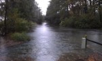
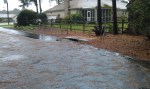
Residents of Lynnhaven Colony filed into Dockside Restaurant on Nov. 17, but instead of appetites they brought questions for the public works officials in attendance.  The city panel and more than 50 residents gathered to discuss solutions to the neighborhood’s common flooding during high tide and inclement weather.

              “The most important and expensive thing you purchase is your home,” Donna Rennick, civic league vice-president, told Phillip Davenport, public works director, before he took the floor.

              “We need to know how we can work with you,” Rennick said. “We need answers.”

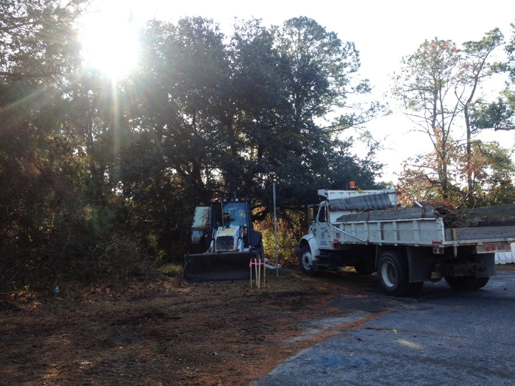
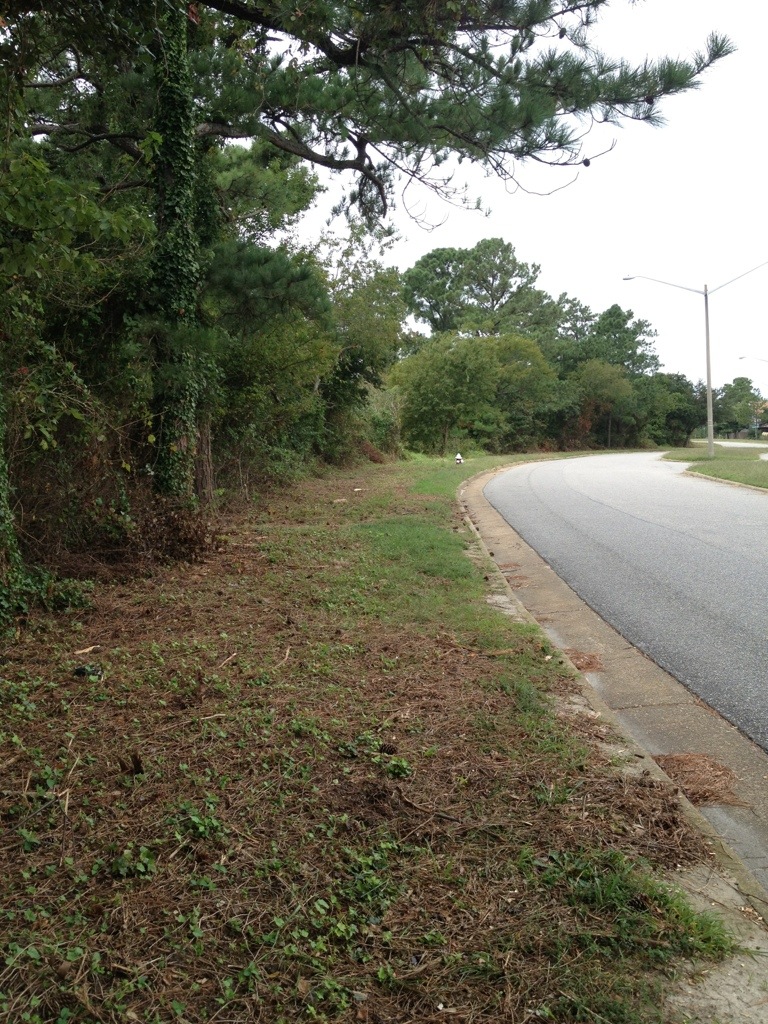
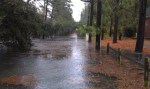
Phillip Roehrs, water resources engineer, presented a project that officials believe would alleviate most of the flooding, but further study is needed to make certain it will do the job.   Lynnhaven Colony is south of Shore Drive, on land that is between the Chesapeake Bay and Long Creek, which is a tributary of the Lynnhaven River.  According to a 2005 study, solving the core problems – feeder ditch improvements, flooding on Shore Drive, relieving flooding in low-lying areas – is estimated to cost $50 million, Roehrs said.   Roehrs added that he was not prepared to provide the residents a timeline of when the project would begin or be completed.

   “We’re at a point where we are thinking of moving,” said Joyce Dunn, a 30-year resident. “After the 2009 nor’easter, the city proposed the same and nothing has been resolved.”

   Dunn’s family has made costly adjustments in their home, such as resurfacing their garage and moving their furnace to the attic.   In about a year, when sidewalk construction on Shore Drive begins, the city plans to start Phase I of the project by putting in the components needed for development of a flood-control system.

   The final plan would provide the community with two tide gates, five water pump stations (adding to the two already in place) and an underground conveyance system.  The current outfalls to the Chesapeake Bay and river would be improved with extra collection systems that would provide a better flow.

   “There are minor tweaks in the works,” Roehrs said. “But it will take a number of years to build and a number of years to finance.”

Currently less than $3 million a year is set aside for the project. City officials are working to come up with a way   to fully finance the project and move forward.

   “Even if we are able to come up with a financing plan where we can have all the money today,” Davenport said, “we can’t do all of the work at one time, it has to be phased.”

Construction around the roads and ditches would make it difficult for residents to get in and out of Lynnhaven Colony, he said.

The city plans to put in place a funding and work schedule, and provide residents with a timeline by December 2013.  In the meantime, city representatives suggested that homeowners have their homes elevated and seek federal funding with the Federal Emergency Management Agency through the Severe Repetitive Loss program.

 “Set an expectation,” resident Vin Melwani told the panel after the presentation.  “I’m a homeowner,” Melwani said. “I just would really appreciate it if you could set a realistic expectation.”

  •            For information about the Federal Emergency Management Agency’s Severe Repetitive Loss

program, contact Erin Sutton, city emergency planner, at 385-1076.

  • For proposed plans and maps of the flood-prone areas off Shore Drive east of the Lesner Bridge, visit http://www.tinyurl.com/ akc9nd6

City Continues Engineering Studies for Immediate Stormwater Solutions East of Lesner Bridge – Results Expected April 2013

The following email was received from Deputy City Manager Dave Hansen in respone to requests that immediate stormwater solutions similar to the one used in Ocean Park be installed in flood prone areas east of the Lesner Bridge in Cape Story, Lynnhaven Colony and Cape Henry neighborhoods.


Eastern Shore Drive Leaders,

Let me begin by attesting the Eastern Shore Drive Storm Water Drainage Area Improvement Initiative is one of our top focus areas as we roll into the new year.  The staff and City leadership are very sensitive to the hardships created when we have intense and long-lasting weather events such as Sandy, Irene, and the Nor’easter of Nov 09.  Following Public Works attendance and briefing last Saturday with the Lynnhaven Colony Civic League and concerns we have received from Cape Henry Shores, Cape Story By the Sea and other concerned citizens in the eastern Shore Drive drainage area, our engineering and operations staff will be undertaking an accelerated analysis of several interim solutions which have been suggested and on the face seem to have merit in providing various degrees of protection from tidal inundation.  Below is a summary of the two phases I have asked our engineering staff to pursue.  Phase I is a data map with summary descriptions so we identify all infrastructure, elevations and drainage areas east of the Lesner.  Completing this on 7 Dec allows us to define the study aspects of Phase II.  I have asked Public Works to complete their assessments and recommendations by the first week in April and to publish a written report NLT 12 April.  Intent will be to post this report on-line for the civic leagues and citizens to review. Here are summaries of the first two phases:

1.    Using City topographic mapping as the base, delineate the drainage sub basins, the drainage systems (open and closed), and the outfalls for the Lynnhaven Colony/Cape Henry/Cape Story by the Sea areas.  This will provide a clear graphic that depicts the ground elevations, drainage areas, and drainage system elements – including outfalls.  This will be used as a tool for the additional analyses identified in Phase 2 and will be suitable for discussions with the BAC and civic leagues when describing how the systems function and why engineering analyses are necessary to support any proposed interim measures such as backflow preventers.  I.e., it’s not as simple as just keeping the tide out, the rainfall runoff has to be able to either be safely stored within the particular drainage area or be able to be discharged with the backflow preventers in place (or a combination thereof).  These products will be ready by December 7.

2.    Each sub basin will have an analysis done to determine the suitability of backflow preventers on the outfall for the particular subbasin; if a backflow preventer is suitable, the type of backflow preventer; the amount of rainfall runoff the subbasin can handle without structural flooding; the stand-by pumping requirements (if any); and the probable costs.  While simply jumping to a “solution” as has been suggested by some,  it is absolutely necessary that the City allow the responsible level of engineering to be done to assure that we do not inadvertently worsen the drainage situation for any particular subbasin.  We are estimating four months for this effort. Expect to deliver a written analysis with recommendations and preliminary costs and timeline by mid-April.

Phase III will be the review and approval process leading to design and construction.  Once we firm up the costs and the competitive process we’ll use to get the work done we can provide a reasonable timeline.  I wish to close this email by ensuring our citizens fully understand these interim solutions as with the permanent solutions have definitive limitations.  At some level of tidal surge and some accumulation and intensity of precipitation all infrastructure improvements will be overcome and mother nature will prevail.  Hopefully implementing interim measures will reduce the risk of moderate storm damage and buy the time for us to consider even grander infrastructure solutions to tackle the bigger more threatening hurricanes and nor’easters we seem to be weathering of late.  Happy Thanksgiving and fingers crossed for a quiet winter storm season. Regards, Dave


Dave Hansen

Deputy City Manager

City of Virginia Beach

(757)385-4242

Reminder – First Landing State Park Volunteer Orientation – Wed. Dec 5th at 5:30pm

Hello Volunteers! 

Volunteer orientation will be presented on Wednesday, December 5th from 5:30 pm – 6:30 pm at the Trail Center. We will give an overview of First Landing State Park and discuss the volunteer program. If it has been five or more years since you have attended a volunteer orientation, please plan to attend. If you are unable to attend, volunteer orientations are offered quarterly so you can try to catch the next one.

Please e-mail or call me if you plan to attend.

Thank you,
Kim Y. Miller
Volunteer / Events Coordinator
First Landing State Park
Phone: 757-412-2308
Cell: 757-536-0088
Fax: 757-412-2315

The contractor will begin to install the wooden guardrail along Marlin Bay Drive Monday, December 12.

From an email from Michael:

The contractor will begin to install the wooden guardrail along Marlin Bay Drive Monday, December 12. They anticipate it will take about 3-4 weeks to complete, however they will have about 40 working days to complete it so if it takes a bit longer they have the availability to do so. Also, the partnership sign that is at the main trailhead will have the panel removed tomorrow for a day or so. The contractor needs to make a few adjustments to make it fit more accurate. If you see the two posts only, please don’t be alarmed. I’m sure you might get a few questions so feel free to pass along the information. If you have any more questions feel free to call or email me.

Michael T. Moore; CNMP
Open Space and Resource Manager
Parks and Natural Areas
Virginia Beach Parks & Recreation

20121130-101929.jpg

“Temporary Bulkhead” at the beloved Lynnhaven Boat Ramp & Beach Facility further explained

From an email from Dave Hansen posted unedited with permission:

Kal & Grace,

FYI – The “Temporary Bulkhead” as shown in the permit application and on the current design plans, is designed with steel sheeting with a tie-back system and a concrete cap. The length is approx 400 LF.

Timber is great for residential bulkheads, but it is not adequate for a commercial/industrial application like this.

Timber would not hold up for the construction duration. The cap would require cleats to tie-off and a timber cap would not provide an adequate anchor for loaded barges, boats, etc., to tie off.

The concrete cap provides more structural stability for the bulkhead design.

This concrete cap bulkhead design is more of a standard section that contractors are used to building.

As an alternate, a more expensive steel cap could be used, but in either scenario (steel or concrete) the cap needs to be more durable than timber.

As promised in my many briefings to your respective organizations we will visit this discussion just past the 50% construction stage to see how we are co-existing with our boating public. Regards, Dave

Dave Hansen
Deputy City Manager
City of Virginia Beach
(757)385-4242

Permit at US ACOE website.
More about dredging, and the replacement for the Lesner Bridge at SDCC HOT page.

SDCC General Meeting Agenda for Monday NOV26 2012

Click here for a printable version of the agends – SDCC Agenda NOV 2012

Shore Drive Community Coalition

Monday 26 NOV 2012

SDCC General Meeting

SDCC General Meeting – Monday, 26 November 7:30 – 9:00 pm

Ocean Park Volunteer Rescue Squad Station (Intersection of Shore Drive and East Stratford Rd.)

Call to order

Meeting topic: Nominations for SDCC Officers for 2013 Election

Vice President’s Report on NOV BAC Meeting

Communications Plan for 2013

Officers’ Reports

President’s Report David Williams

Vice President’s report Grace Moran

Secretary’s Report Todd Solomon –Sept Minutes

Treasurer’s Report Carol Collins

Update on issues: Open questions from the floor

Old Business Shore Drive Issues

Storm Water Flooding of Neighborhoods

New Business

Adjourn

Next SDCC- Monday DEC 17, 2012

PLEASE NOTE DATE CHANGE

Ocean Park Volunteer Rescue Squad Center

Speaker- TBA

Please check http://www.sdcc.info for more information on area news and events

Jetty study at Lesner Bridge, Planning Commission recommends CBF wind turbine proposal at PHP

About Jetty study at Pilotonline:

Once the study is complete, the corps will present its findings to the city. Then both parties will decide whether to move forward with building the structures, said Phil Roehrs, the Virginia Beach coastal engineer.

Roehrs said the city would consider the jetties “only if the study shows they can be built in an environmentally sound way.”

Previously at SDCC.info. We scooped the Pilot. Thanks Andy.

About wind turbines at CBF’s facility on PHP at SavePHP.org:

Hopefully CBF and SmithGroup JJR will far exceed the standard in the wind turbine they use so as to minimize bird conflicts since PHP is a vital stop in the Atlantic Flyway.

Online Petition to Move Electronic Roadway sign and Save Live Oaks

Three electronic ITS traffic/safey warning signs are being installed on Shore Drive. 

1 – West of Marlin Bay Drive in the median

2- West of First Landing State Park Bayside entrance (northside of road)

3- Northend near 89th street

The signs are part of a Federally funded project and were approved by the City’s Public Works department in 2008.  In addition to the signs being big and ugly, the sign installed near the State Park will require several of the City’s official trees, the live oak, to be removed.

Members of the Friends of Live Oaks have started an online petition requesting the sign be relocated to the median to avoid tree removal.  You can sign the petition at the following link

 http://www.thepetitionsite.com/takeaction/702/346/384/


Close up of sign near Park


Trees between sign (located far left just behind the white car) and Park entrance to be removed.

Editorial entitled Negotiate to save Lynnhaven property, Pleasure House Point.

Read entire editorial entitled Negotiate to save Lynnhaven property at Pilotonline.com.

It’s time for the firm, city and foundation leaders to work together for the common good and figure out a way to preserve those four acres.

And:

…whether through negotiations with the developer that involve a land swap, tax breaks or some other method.

One of the groups that worked to preserve PHP. A team of Kemps Landing Magnet School eighth-graders and the sixth-grade class at Cape Henry Collegiate School have a shared vision: to preserve…

Bayfront Advisory Committee Meeting – Thursday Nov. 15th at 3:30pm

Bayfront Advisory Committee to Meet November 15

The Bayfront Advisory Committee will meet Thursday, November 15, at the Virginia Beach Resort and Conference Center, 2800 Shore Drive, from 3:30pm-5:30pm

The agenda for the meeting will include the following:

  • Update on public and private projects in the Bayfront area
  • Update on committee activities in the Bayfront area

 There will be an opportunity for presentations from the public on projects in the Bayfront area. The committee generally concludes its deliberations around 4:30pm. The meeting is then opened to the public for comments.

For additional information or to obtain a copy of the draft agenda, contact Faith Christie in the Planning Department at (757) 385-4621 or fchristi@vbgov.com. For more information regarding the Bayfront Advisory Committee, visit www.VBgov.com/Bayfront.

“Kristin Mazur, project manager for the Norfolk District Lynnhaven Inlet Jetties Navigation Project with the city of Virginia Beach, Va., explains the federal interest determination study process and timetable, Oct. 19, 2012, to add a 1,000-foot jetty in front of the Lesner Bridge.”

Learn more at US Army Corps of Engineers Norfolk District article.

The federal study will determine if jetties or a combination of coastal structures is cost-effective in reducing critical shoaling and annual costs of maintaining the navigation channel, as well as reducing damages incurred on structures in the channel due to continuous wave action.

Multiple car break ins, drunk driving including hitting various objects, driving on bike path, vandalism and more in Cape Henry Shores and Cape Story by The Sea last night.

Neighborhood Watch from CSTBS will be attending the Citizen’s Advisory Committee meeting on Wednesday night at the Second Precinct at 820 Virginia Beach Blvd and intend to bring all this up. Everyone is invited to attend this meeting to air complaints, and to meet with police and other City officials. They really appreciate public comments. The meeting starts at 7:00 p.m.

City to discuss private property and Marlin Bay extension next to PHP at next Council Meeting

Watch a WVEC.com news coverage about private property and Marlin Bay extension slatted for property next to PHP.

Previous press about this at SDCC.info.

“If the lots are built upon and the road extended, “unfortunately it would sour the overall project,” said Christy Everett, regional director of the Chesapeake Bay Foundation.”

More press about 100% of Pleasure House Point not being preserved.

“Pleasure House Point Faces New Development

… plans have quietly moved ahead to build duplexes and extend a road through two areas in the tract, known as Pleasure House Point.”

From Pilotonline.com:

Turns out there’s a loophole in the celebrated purchase and preservation of Pleasure House Point, the largest undeveloped tract left on the Lynnhaven River, loaded with sand dunes, maritime forest and waterfront vistas.

Note the amount of trees and vital habitat that is at risk for destruction. Birds, including those migrating in the Atlantic Flyway, depend on Pleasure House Point and it’s open space to survive.

Partial shot of 1 page of plans shown upside down.

“Please be aware of a dangerous “quick sand” environment on the beach. A resident of Baylake Pines sank to his waist on Tues evening while walking his dog and struggled to get out. He notified the city.”

Pulled from Ocean Park Civic League Facebook page …. from Baylake Pines:

Please be aware of a dangerous “quick sand” environment on the beach. A resident of Baylake Pines sank to his waist on Tues evening while walking his dog and struggled to get out. He notified the city. Until it is rectified, please pass the word. Tell the kids to beware! It was suggested that you don’t walk alone and do walk during daylight hours. Pass the word please–its a pretty day for beach-goers.

Email sent to the city (Emergency Mgmt), Tues., Nov. 6:
This is to alert you of a dangerous situation on the beach at the foot of Seaview Avenue in Chicks Beach. I sank to my waist in the sand while walking my dog this evening on the beach in front of the bulkhead immediately to the west of Seaview Avenue. I was able to pull myself out of the sand after a ten to fifteen
minute struggle. I alerted the City backhoe driver who was at work placing fill material on the beach at the end of Seaview Avenue, and suggested that he contact his supervi…sor to report the situation.

Although I am not an expert on these conditions, I believe that at certain tide levels, the beach in front of the bulkhead can become “quick” due to its low elevation and other features of the geography behind the bulkhead. I believe that this poses a serious hazard to the public.

Please take appropriate measures to warn the public of this dangerous condition.

“We will hold the Grand Illumination of the Historic Cape Henry Lighthouse this year on 30 Nov at 5 p.m. The event will be open to the public this year.”

Please share this Info.

If you have any questions, please let me know. Thanks!

Scott Mohr
Public Affairs Officer
Joint Expeditionary Base Little Creek-Fort Story

Flooding in Cape Story caused by backflow through First Landing outfalls

The photos below show the high tide flooding that occurred Monday Oct. 29th around 10:30am high tide cycle for Long Creek.  The water level above the SW grate on First Landing was about 14 inches.  Estimate for the height of the high tide for this event is close to 7.0 feet based on 2006, 2009 Nor’Ida and 2011 Irene.

At least 8 homes between Calvert and Wake Forest had water come into their homes.  The one at the end of First Landing Lane had at close to 18 inches and will need dry wall and insulation replaced.  All of the flooding for these homes was a direct result of the tidal surge coming backwards through the First Landing outfalls in the Cape Henry canal.

Based on observations during the storm, water from the Cape Henry canal never breeched the roadway crest at the intersection of Admiral and First Landing.  Water entered the ditch along the trail and filled the low lying areas and then flowed west toward Wake Forest.  The maps produced after the 2009 event were very close to what actually happened.

Based on the success of the backflow prevention device in Ocean Park, some type of device needs to be installed in the First Landing outfalls ASAP.  The flooding damage to Cape Story as a result of Sandy could have been prevented.  Based on past experience from 2006, 2009, 2011 and 2012, a backflow device will function satisfactorily for events that have a high tide less than 8.5 feet.  This should be acceptable for most events.  Of course, if a Cat 2 storm hits us directly, we’re all in trouble.  Nothing will save us and we know that.