Category Archives: News
SDCC General Meeting Notice and Agenda – Monday Feb. 25th
Click here for a printable versions of the agenda SDCC FEB 2013 Agenda (1)
Shore Drive Community Coalition
Monday 25 FEB 2013
SDCC General Meeting
SDCC General Meeting – Monday, 25 FEB – 7:30-8:30 pm
Ocean Park Volunteer Rescue Squad Station (Intersection of Shore Drive and East Stratford Rd.)
Call to order
Meeting topic: (1) Neighborhood Security Measures for residents
(2) VA State Personal Self Defense Laws by David Williams
Officers’ Reports:
President’s Report David Williams
Vice President’s report Rick Mercadante
Secretary’s Report Todd Solomon –Jan Minutes
Treasurer’s Report Ryan King
Update on issues:
Old Business
New Business
Adjourn
Next SDCC- Monday March 25, 2013 (Please note Easter is 31 March)
Ocean Park Volunteer Rescue Squad Center
Speaker- TBA
Please check www.sdcc.info for more information on area news and events
Fatal accident reported on Shore Drive near First Landing State Park – 2/14/13
It’s very unfortunate, but after almost 3 years without a fatality on Shore Drive (April 2010), another tragic death has occured.
The following was taken from WTKR’s website:
UPDATE: As of 4:00pm., Shore Drive remains closed to East Bound traffic from Kendall Street to Fort story.
Virginia Beach, Va. – Police tell NewsChannel 3 one person has died and one has been injured in a vehicle crash on Shore Drive near First Landing.
It happened at 1:15 p.m., Thursday, February 14, 2013, in the 2500 block of Shore Drive near First Landing. Police say a vehicle was heading eastbound in the 2500 block of Shore Drive near First Landing Park, when it crashed.
One person was reported deceased; and a second person was injured.
Eastbound traffic on Shore Drive is closed from Kendall Street to Fort Story.
NewsChannel 3 is working to find more details. Watch starting First at Four for updates.

Citizens Invited to Help Participate in Review and Adoption of Community Sustainability Plan
The City of Virginia Beach invites all residents, business owners, community leaders and other stakeholders who have an interest in how the city plans, manages, protects and promotes its current and future sustainability initiatives to participate in the City Council’s review and adoption of “A Community Plan for a Sustainable Future” over the next several weeks.
The City Council will be holding a public comment session on Tuesday, Feb. 12 beginning at 6 p.m. in the City Council Chamber, Building 1, 2401 Courthouse Drive, 2nd Floor.
The City Council will also be holding a public hearing and vote on adoption of the plan on Tuesday, Feb. 26 beginning at 6 p.m. in the City Council Chamber, Building 1, 2401 Courthouse Drive, 2nd Floor.
The draft plan is available for the public to review prior to these meetings at http://www.vbgov.com/government/offices/eso/sustainability-plan/Documents/vb-sustainability-plan-web.pdf. These public input meetings are the final steps in a yearlong public outreach process to seek ideas and direction from citizens to help guide the City in the development of its first comprehensive Community Sustainability Plan.
For additional information, please contact Clay Bernick in the Planning Department/Environment and Sustainability Office at 385-4899 or visit www.VBgov.com/sustainplan.
Bayfront Advisory Committee to Meet Feb. 21
The Bayfront Advisory Committee will meet Thursday, Feb. 21, at the Virginia Beach Resort and Conference Center, 2800 Shore Drive, from 3:30 p.m. to 5:30 p.m.
The agenda for the meeting will include the following:
- Update on public and private projects in the Bayfront area.
- Update on committee activities in the Bayfront area.
There will be an opportunity for presentations from the public on projects in the Bayfront area. The committee generally concludes its deliberations around 4:30 p.m. The meeting is then opened to the public for comments.
Also, the Bayfront Advisory Design Subcommittee will meet on Feb. 21 from 2 to 3:15 p.m. at the Resort and Conference Center. The subcommittee will continue its deliberations regarding recommendations for commercial design standards along the Shore Drive corridor.
For additional information or to obtain a copy of the draft agenda, contact Faith Christie in the Planning Department at (757) 385-4621 or fchristi@vbgov.com. For more information regarding the Bayfront Advisory Committee, visit www.VBgov.com/Bayfront.
Coolest neighborhood on Shore Drive? Ocean Park of course! Advertising proves it.
Full disclosure – I live in Ocean Park … but ya can’t argue with VB’s choice of which neighborhood to market.
And this was in a magazine called AARP or something like that:
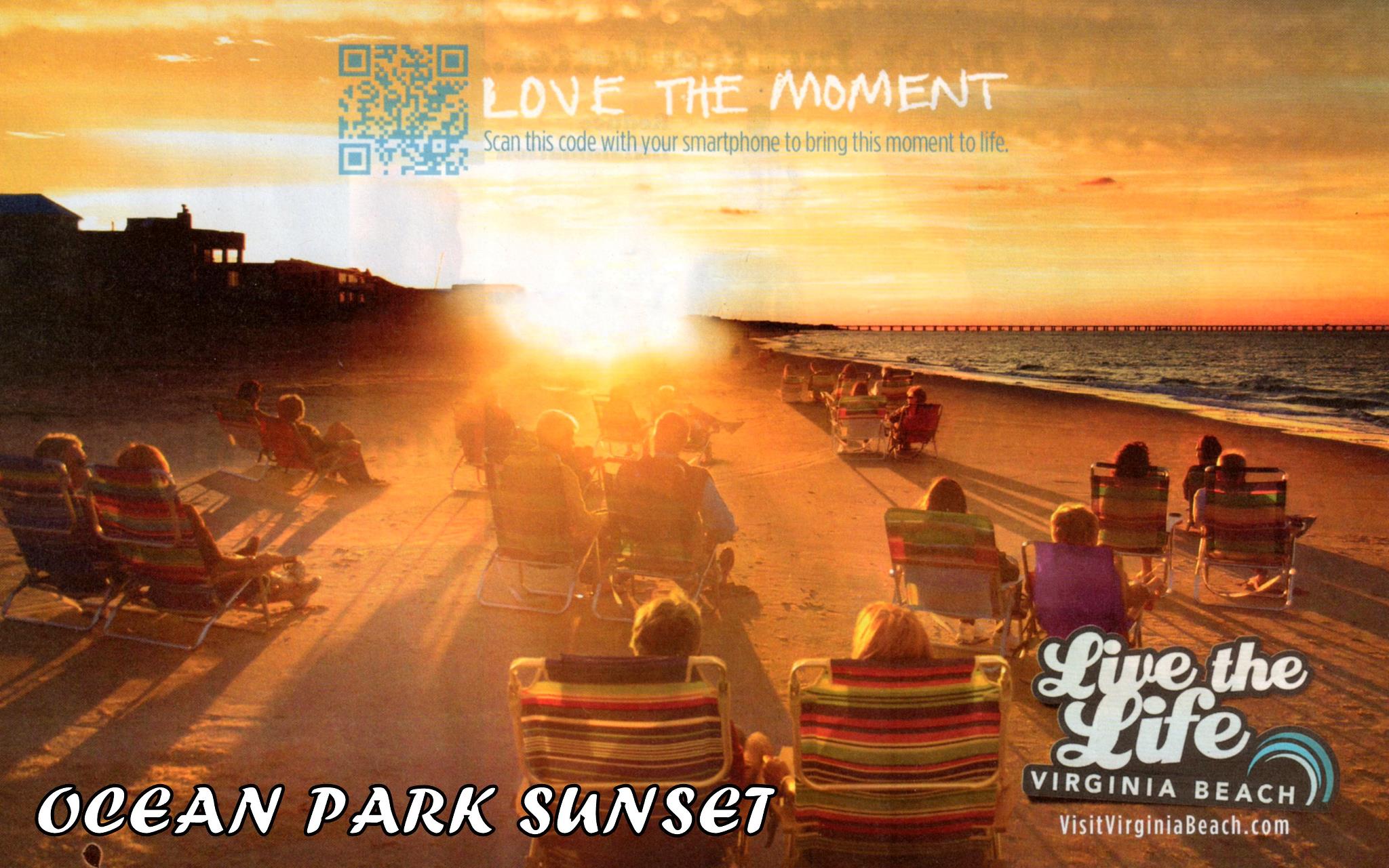
Ocean Park baby!
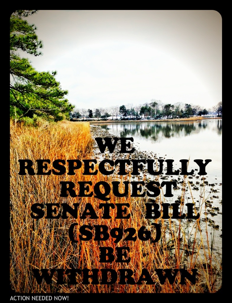
Chesapeake Bay Foundation Action Alert – Withdraw SB926 Now
The following Action Alert has been sent out by the CBF. Click here for an easy way to take action
The Chesapeake Bay and her precious wetlands need your help TODAY.
Senate Bill 926, a measure that weakens the authority of local wetlands boards, will be considered at tomorrow’s Senate Agriculture, Conservation, and Natural Resources. Your state senator, Sen. Jeff McWaters, has introduced this bill. Please ask Senator McWaters to withdraw this bill, which will have unintended harmful consequences.
CBF and many other conservation organizations oppose this bill, as it undermines Virginia’s effective, four-decades-old tidal wetlands program that relies upon local citizen wetland boards, with oversight by the Virginia Marine Resources Commission (VMRC), to protect our valuable tidal wetlands.Time is of the essence. Please contact Sen. McWaters today, and tell him SB 926 is a step backward and to please withdraw it immediately!
Wording for Wetlands Board Code Modification in the City’s Legislative Agenda
Here is some more background information regarding SB926. The attached document was pulled from this year’s City Legislative Agenda and was used to start the ball rolling on SB926.
City Staff Information Regarding SB926
The following updated wording of SB926 was provided by Mr. Dave Hansen, Deputy City Manager, earlier today
10. Governmental activity in wetlands owned, leased or within an easement or right to use held by the Commonwealth or a subdivision thereof or a local government approved neighborhood navigation dredging project within a Special Services District adopted by the local governing body in accordance with Va. Code Section 15.2-2400, et seq.
170 4. For governmental activity not falling within the exceptions set forth in § 3 (10) above,
the board shall not condition approval on compensatory mitigation for adverse impacts if compensatory mitigation is required for the same activity by the Commission pursuant to Title 28.2 of the Code of Virginia, the Department of Environmental Quality pursuant to Title 62.1 of the Code of Virginia or § 401 of the Clean Water Act, or the United States Corps of Army Engineers pursuant to § 404 of the Clean Water Act and § 10 of the Rivers and Harbors Appropriations Act of 1889
Mr. Hansen also provided the following justification for making the legislative request that created SB926
SB926 is a modification of the existing law regarding government activities in wetlands. The City Council has asked that the language be modified to expand the definition of government projects to include bon-a-fide easements and the Navigation SSD Dredging Projects. These additions modify the 1992 law of Va. Code Section 28.2-1302. The specifics are:
- 1. In Section 3, Paragraph 10, the addition of “or within an easement or right of use held by the Commonwealth or a subdivision thereof.” The absence of reference to a legally binding easement has significantly disrupted the ability of government entities to implement timely and cost effective projects when substantiated, documented, and City Attorney validated legal instruments allowing the public use of property are in existence. The “right of use” reference addresses the potential existence of a documented conveyed right other than title, easement or lease. This instance occurred in the construction of the Constitution Drive Extension across Thalia Creek in Virginia Beach which delayed construction for over 12 months while properties were dedicated and accepted by the Council to establish the relationship of fee simple ownership.
- 2. Also in Section 3, Paragraph 10 was the inclusion of additional specifying language, “or a local government approved neighborhood navigation dredging project within a Special Services District adopted by the local governing body in accordance with VA.Code Section 15.2-2400.” This language is added to specifically allow SSD Navigation Projects to be considered government projects as they are engineered, constructed, funded and administered by local government staff and therefore, also exempt from Local Wetlands Board review. This in no way is intended to amend or circumvent the State and Federal permitting process. All navigation SSD projects will have permit applications submitted through the Joint Permit Application Process managed by VMRC for the purpose of obtaining State permits from both DEQ and VMRC as well as federal permits from the Corps of Engineers. This specific exemption from Local Wetlands Board review solidifies the need for all three segments of the neighborhood SSD projects (City spur, neighborhood SSD channel, and individual connections) as being the complete project for the purpose of design, permitting and contracting. By making these projects a government activity all mitigation becomes eligible for use in a government mitigation bank which the City of Virginia Beach is establishing as a result of the Pleasure House Point Purchase and its partnership with the Chesapeake Bay Foundation. It is essential this specific language be included in Senator McWaters’ bill so that Lynnhaven River Now can create a Trust for the oversight of mitigation funds related to impacts in the Lynnhaven.
So as you see, this is a definitional clarification for what constitutes a government project that is exempt for local wetland board review. The City Council sponsors feel that a permit application submitted by the City Manager’s Office to perform a City Council directed Navigation SSD Project that has been formulated by the City staff charged with providing the regulatory staff research and recommendations for the Local Wetlands Board creates a conflict of interest. The staff that prepares the application should not be the staff support charged with reviewing and recommending approval of that application. Currently the definition of “governmental activity” for the Local Wetland Boards, due to legislation for the Virginia Marine Resources Commission (VMRC), is limited to lands the government either owns or holds an easement or right-of-way over. The language must be modified as it is antiquated and not consistent with the SSD legislation, which was created decades after VMRCs legislation. This in no way circumvents the state and federal permit review and approval process which this City adheres to on all government projects.
The neighborhood SSD program created by the City Council of Virginia Beach, following state enabling legislation available to all coastal communities in Virginia, is a tremendous opportunity for waterfront residents to regain navigable access to city channels. The SSD program is an essential program for many neighborhoods who could not otherwise dredge because the city is able to bundle the regulatory process, tax residents over a period of 16 years, thus building in a means to finance the effort making it cost effective. Additionally, the “mud tax” which the City’s wetland board collects from private residential projects does not take into account that exposed sediment (“non-vegetated wetland” – or “mudflat” exposed at low tide) is “natural” versus a consequence of sedimentation from surrounding development. The “mud tax” adds $112.50/cy ($12.50 per square foot x 9 square feet per cubic yard) to the cost of a project currently estimated to cost $30/cy (surveying, engineering, permitting and dredging) to remove the mud. It is this outrageous mud tax that has caused these project to be unaffordable. In a matter of speaking this tax could be viewed as a prohibition to the property rights of waterfront home owners.
The Local Wetland Board does not have jurisdiction over subaqueous river bottoms. These Projects will help to restore the environmental quality of the Lynnhaven River by improving the volume of water flow which will improve the tidal cleansing of the river. All of which will improve the health of fish and shell fish in the river which is of major environmental benefit to the city and its citizens. I could understand the concern that the Local Wetland Board would have regarding tidal wetlands located around the point where dredge spoils are removed from the river but this will be covered in the state and federal permitting. Notwithstanding their normal concerns, all of the Projects are located within the river proper and not in the tidal wetlands. It would appear that the only other concern that the Local Wetland Board could possibly have is where non-vegetative wetlands and subaqueous river bottom overlap. Subaqueous river bottom and non-vegetative tidal wetlands are generally one in the same and determining where one starts and stops is of no environmental consequences. Finally, the public is not further served in any way by requiring the waterfront property owner and the public to spend additional time and money to file and process redundant permits with their City Council appointed Local Wetland Board. Additionally, the fees that the Wet Lands Board could impose on the property owners were arbitrarily established several years ago by the Local Wetland Board without empirical environmental or economic basis. It is beyond reason to require the property owner to submit to additional public hearings only for the property owners to be required to pay additional fees. To simply duplicate the review of the state and federal agencies that have jurisdiction over such project with an unnecessary local bureaucratic layer is not appropriate.
URGENT NOW: “PLEASE WITHDRAW SENATE BILL SB926” PLEASE CONTACT SENATOR MCWATERS NOW
Please call and/or email Senator McWaters:
Respectfully ask Senator McWaters to withdraw Senate Bill SB 926.
EMAIL Senator McWaters & His Aid
PHONE Richmond Office: (804) 698-7508
Senator McWaters Contact Info
WHY?
Dear Gentleman,
I respectfully request that Senate Bill (SB926) be withdrawn.
Removing local Wetlands Board review of local City projects is unacceptable.
Citizen engagement at the local level must be maintained in order to keep trust in government.
The current review process for “28.2-1302 of the Code of Virginia, relating to the jurisdiction of local wetlands boards” results in State owned wetlands projects being reviewed by State commissions (VMRC) and locally owned wetlands projects being reviewed by local Wetlands Boards.
This is the correct method and must be protected.
Moving review boards out of the local area places an unfair burden on citizens and their rights for public comment.
Additionally, local Wetlands Boards are more familiar with the particulars of local projects and are best suited to review these applications.
Sincerely,
Todd Solomon
Shore Drive Community Coalition-Secretary
Maintaining the Status Quo for Shore Drive, check out http://www.sdcc.info
ALSO:
It could undermine Virginia’s no net loss goals for preservation of wetlands acreage and function.
It could undermine government openness and transparency by imposing additional barriers to public participation in the local public hearing of projects that would impact state-protected wetlands.
PLEASE CONTACT SENATOR MCWATERS NOW
Senator Jeffrey L. McWaters
Republican-District 8
Capitol Office
Senate of Virginia
P.O. Box 396
Richmond, VA 23218
Email: district08@senate.virginia.gov
Phone: (804) 698-7508
Fax: (804) 698-7651
Room No: 310
Legislative Assistant: Cheryl Simmons, Christen T. Smith
District Office
1207 Laskin Road
Virginia Beach, VA 23451
Phone: (757) 965-3700
Legislative Assistant: Cheryl Simmons, Christen T. Smith
1207 Laskin Road
Virginia Beach, VA 23451
Phone: (757) 965-3700
As of the time of this post, this Senate Bill SB926 could be heard Thursday.
UPDATE: read the bill. Start here.
Contractor to Perform Surveys to Support Storm Water Study – Feb 4th to May 31st
To support a Storm Water study of areas east of the Lesner Bridge, the City has hired Kimley-Horn and NTX to perform field surveys in Cape Story, Cape Henry Shores and Lynnhaven Colony.
Contractors may ask residents to allow a survey markers to be held at an home or garage entrance while the elevation survey is taken.
Please see the attached City of Viriginia Beach letter for more details. Click here Storm_Water_Survey_Letter
Jan28 Agenda for SDCC meeting. All welcome to come and participate.
Click here for a printable version of the agenda – SDCC Jan 2013 Agenda
Shore Drive Community Coalition
Monday 28 JAN 2013
SDCC General Meeting
SDCC General Meeting – Monday, 28 JAN – 7:30-8:30 pm
Ocean Park Volunteer Rescue Squad Station (Intersection of Shore Drive and East Stratford Rd.)
Call to order
Meeting topic:
(1) Introduction of SDCC Officers for 2013
(2) Virginia Beach Phase III- Storm Water Mitigation Program Lesner Bridge East to Great Neck Rd By Todd Solomon
Officers’ Reports:
President’s Report David Williams
Vice President’s report Rick Mercadante
Secretary’s Report Todd Solomon –DEC Minutes
Treasurer’s Report Ryan King
Update on issues:
Proposed State Legislation being supported by City of Virginia Beach
- Bill to allow hydraulic pumping of sand from Chesapeake Bay onto Bayfront beaches. Beaches and Waterways Commission has been tasked to discuss possible funding streams (i.e. Special Tax Districts similar to Sandbridge)
- Bill (SB 926) to allow by passing of Wetlands Board review of Neighborhood Dredging Projects. Who from the City requested this and why? Why would the citizens remove a valuable part of the review process?
Old Business
New Business
Adjourn
Next SDCC- Monday FEB 25, 2013
Ocean Park Volunteer Rescue Squad Center
Speaker- TBA
Please check http://www.sdcc.info for more information on area news and events
“Adoption of wetlands zoning; governmental activity in wetlands. Removes from Virginia’s standard wetlands zoning ordinance the condition that wetlands be owned or leased by the Commonwealth if a governmental activity occurring there is to be authorized.”
Work on CBF site at PHP
Check out SavePHP.org to learn more about work on Pleasure House Point.
City Page 2012 accomplishments
One was preserving PHP!
Pleasure House Point: Bought the last large undeveloped tract on the Elizabeth River – 118 pristine acres.
/blockquote>Oops.
Irregardless of a typo, we’re ecstatic preserving PHP was a highlight too!
Noticed more files available at replacement for Lesner Bridge CIP Project Page
Added a list of what’s available at our SDCC.info/Hot page. Scroll down to find info about bridge.
Direct link to CIP Project Page for Lesner Bridge.
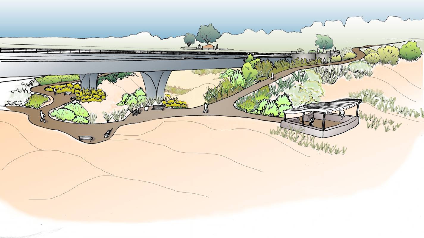
Landscaping Concept Under Bridge
Construction Impacts – Lesner Bridge Replacement Project
Sneak peak of power point presentation pulled from the Official City Project Page.
Construction – Begin July 2013; Complete July 2016
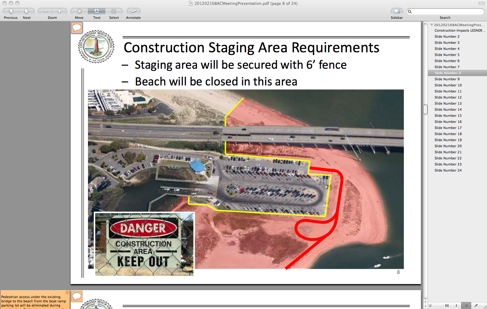
One image from presentation
Download presentation from VBGov.com. [24 page PDF]
Note: If you are viewing presentation on a Mac in Preview – you can watch in full screen slideshow mode.
You can also view each slide & read notes for each by clicking on small cartoon bubble icon in upper left corner of each slide.
More info about sand replenishment including study by VIMS
Forwarded from previous OPCL President:
Hope at receiving this you had a festive holiday season and are ready to do great things for our City in 2013. Attached you will find a draft of the legislation Chris Stolle is carrying for the City to set the ground work for a collaborative process of creating a sand replenishment program for the Chesapeake Bay Beaches. Following completion of the Council funded study by VIMS (can be found at http://www.vbgov.com/government/departments/public-works/coastal/Documents/cxb-shoal-report-12-11.pdf )[246 Page PDF]. The study focused on Chesapeake Beach but we are confident the sizeable deposits of suitable material exist offshore of all our Chesapeake Bay Beaches. Please share with your Commission/Board and if you would like Phil and I are more than happy to attend your next meeting to discuss our program initiative. As this has the unanimous support of the City Council we would like to receive both the Beaches and Waterways Advisory Commission and the Bayfront Advisory Committee endorsements. The Norfolk City Manager’s office is endorsing the legislation as well. Also request that once your organizations are behind the initiative that you take the opportunity to let our General Assembly Delegation know of your support. Please call if you have questions. VR Dave
Dave Hansen
Deputy City Manager
City of Virginia Beach
(757)385-4242
Download the VIMS study entitled A Geotechnical Evaluation of Chesapeake Beach for Beach Quality Sand. [246 Page PDF]
VIMS is the Virginia Institute of Marine Science.
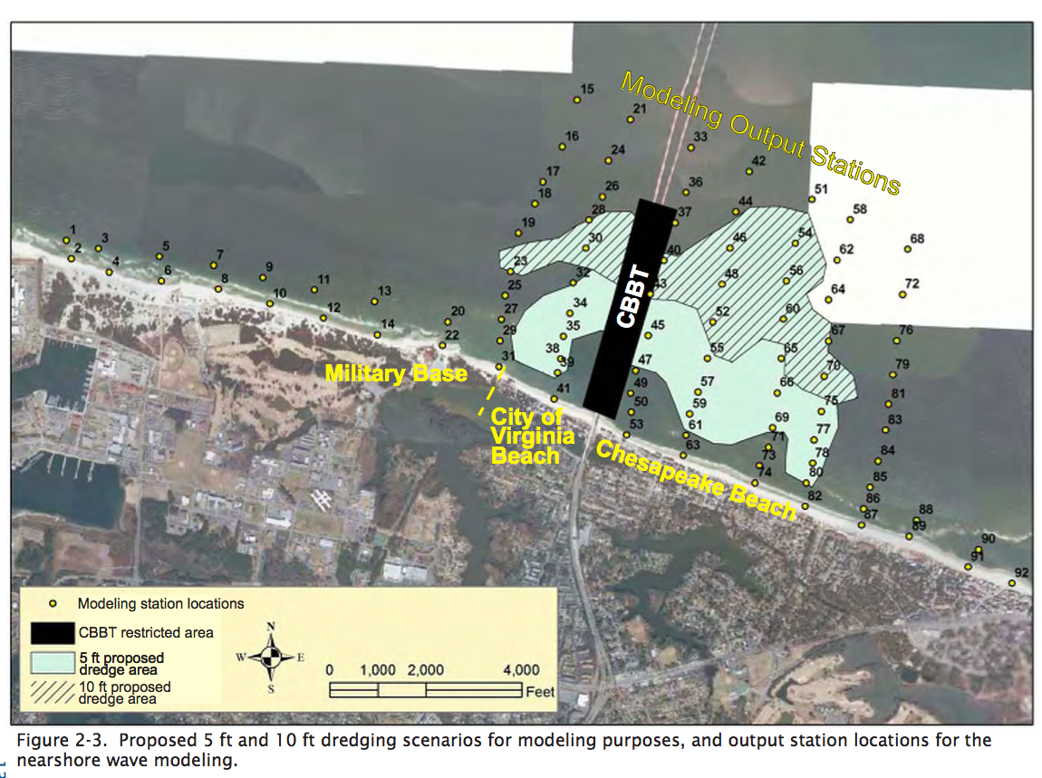
One image from VIMS study
Have you heard Plaza Azteca & shopping center at Great Neck Road…
…is getting bulldozed for a pharmacy?
Virginia Beach Citizens’ Police Academy info
From Cape Story neighborhood watch:
Virginia Beach Citizens’ Police Academy
Monday, January 07, 2013 · 10:00 am
The Virginia Beach Citizens’ Police Academy provides an excellent opportunity for citizens, ages 21 and up, or 18 and in college, who work and/or live in the City of Virginia Beach, to become familiar with the day-to-day operations of the police department. This will enable participants to gain a better understanding of the procedures, guidelines, responsibilities, demands, personnel, equipment, policies, and laws that guide the department’s decisions. Citizens will hear the accounts and experiences of a wide variety of police personnel and will also engage in hands-on activities. This class is not intended to make citizens into police officers but to allow citizens to learn more about police operations. Citizens will become informed as to the actual role of the police and, in return, the police will benefit from the wealth of knowledge the citizens can give about their community. A police ride-along opportunity will be offered during the session for observation of the officer’s daily duties.
Sponsored by the Citizens Police Academy Alumni Association, the 35th session will run from February 5, 2013 through May 14, 2013, with classes held every Tuesday night from 6:30 p.m. – 9:30 p.m. The classes will be held at the Law Enforcement Training Academy located at 411 Integrity Way in Virginia Beach. Applications are now being accepted and are available at any Virginia Beach Police Precinct, the Crime Prevention Unit Building #15 at the Municipal Center, or you can print a copy from this address: http://www.vbgov.com/government/departments/police/opsdiv/Documents/PD045.pdf.
Completed applications for this session must be received by the Crime Prevention Office by Friday, January 18, 2013. Please do not drop off completed applications at a police precinct. Seating is limited.
Topics covered in the academy include:
Recruitment, Selection, & Training
A Day in the Life of a Patrol Officer
Firearms Safety & Range Operations
Deadly Force Encounters
Forensics
Basic Criminal Law
Animal Control
History of Law Enforcement
Office of the Commonwealth’s Attorney
Crime Prevention Programs
Crisis Intervention Team
School Resource Officer Program
Criminal Investigations
PhotoSafe Red Light Enforcement Program
Volunteer Opportunities
Jail Tour
K9, SWAT, Bomb Squad, & Helicopter Unit
Media Relations
Law Enforcement Technology
Special Investigations (narcotics, vice, & gangs)
For further information, contact MPO Jeff Eaton at 385-1066, bjeaton@vbgov.com
